Tow Hill
| Tow Hill | |
|---|---|
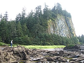 Tow Hill on Graham Island | |
| Highest point | |
| Elevation | 125 m (410 ft) |
| Prominence | 118 m (387 ft) |
| Listing | List of volcanoes in Canada |
| Coordinates | 54°04′27.1″N 131°47′56.1″W / 54.074194°N 131.798917°W |
| Geography | |
| Location | Graham Island, British Columbia, Canada |
| District | Queen Charlotte Land District |
| Topo map | NTS 103J4 |
| Geology | |
| Age of rock | 2 million years |
| Mountain type | Volcanic plug |

Tow Hill is a large isolated volcanic plug located 21 km (13 mi) east of Masset on the north end of the of northeast Graham Island in Haida Gwaii, British Columbia, Canada, east of McIntyre Bay and near the mouth of the Hiellen River,[1] which is the site of Hiellen, a now-abandoned Haida village and of the , on the site of that village. Formerly Tow Hill Provincial Park, it is now part of Naikoon Provincial Park, which covers most of the northeastern flatland of Graham Island.
Tow Hill is associated by the editors Canadian Mountain Encyclopedia with the Queen Charlotte Mountains which in turn form part of the Insular Mountains,[2] but it is not physically part of the range, and is separated from mountainous parts of Graham Island by expanses of forested flatland-marsh and is properly designated as being on the , one of the lowland areas of Haida Gwaii not in the Queen Charlotte Mountains.[3]
Tow Hill consists of faceted columnar-jointed basalt columns that solidified about two million years ago during the Pleistocene period.
"This feature is an eroded volcanic plug - the most distinctive navigational landmark on the entire North Beach. Tow is derived from a Haida word that rhymes with "cow", and means place of food. Many legends about its origin and the significance of the blowhole at the base of the hill......"[4]

Looking Northeast from Tow Hill at North Beach

Looking down from Tow Hill
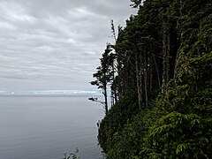
Looking North from Tow Hill; Alaska on the horizon

Looking South from Tow Hill


See also[]
- Volcanism in Canada
- List of volcanoes in Canada
References[]
- ^ "Tow Hill". BC Geographical Names.
- ^ "Tow Hill". Bivouac.com.
- ^ S. Holland, Landforms of British Columbia, Bulletin 48, BC Prov Govt, 1976 and 1964
- ^ Dalzell, Kathleen E; Queen Charlotte Islands - Book 2: of places and names; Prince Rupert: Cove Press, 1973
Coordinates: 54°05′00″N 131°48′00″W / 54.08333°N 131.80000°W
This article about a location in British Columbia, Canada is a stub. You can help Wikipedia by . |
- Volcanic plugs of British Columbia
- Mountains of British Columbia under 1000 metres
- Graham Island
- Pleistocene volcanoes
- British Columbia geography stubs