Townsend, Delaware
Townsend, Delaware | |
|---|---|
 House on Main Street | |
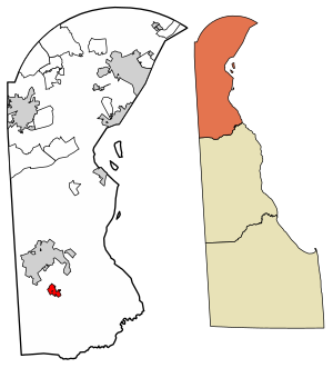 Location of Townsend in New Castle County, Delaware. | |
 Townsend Location within the state of Delaware | |
| Coordinates: 39°23′42″N 75°41′30″W / 39.39500°N 75.69167°WCoordinates: 39°23′42″N 75°41′30″W / 39.39500°N 75.69167°W | |
| Country | |
| State | |
| County | |
| Incorporated | 1885 |
| Government | |
| • Mayor | Tom McDonald |
| Area | |
| • Total | 1.04 sq mi (2.69 km2) |
| • Land | 1.04 sq mi (2.68 km2) |
| • Water | 0.00 sq mi (0.00 km2) |
| Elevation | 69 ft (21 m) |
| Population (2020) | |
| • Total | 2,717 |
| • Density | 2,622.59/sq mi (1,012.36/km2) |
| Time zone | UTC−5 (Eastern (EST)) |
| • Summer (DST) | UTC−4 (EDT) |
| ZIP code | 19734 |
| Area code(s) | 302 |
| FIPS code | 10-72510 |
| GNIS feature ID | 214755[2] |
| Website | http://townsend.delaware.gov |


Townsend is a town in New Castle County, Delaware, United States. The population was 2,049 at the 2010 census, an increase of 492.2% from 2000.[3] The center of population of Delaware is located in Townsend.[4]
Geography[]
Townsend is located at 39°23′42″N 75°41′30″W / 39.39500°N 75.69167°W (39.3951115, –75.6915973).[5]
According to the United States Census Bureau, the town has a total area of 0.6 square miles (1.6 km2), all of it land.
Demographics[]
| Historical population | |||
|---|---|---|---|
| Census | Pop. | %± | |
| 1880 | 199 | — | |
| 1890 | 387 | 94.5% | |
| 1900 | 399 | 3.1% | |
| 1910 | 494 | 23.8% | |
| 1920 | 453 | −8.3% | |
| 1930 | 421 | −7.1% | |
| 1940 | 544 | 29.2% | |
| 1950 | 441 | −18.9% | |
| 1960 | 434 | −1.6% | |
| 1970 | 505 | 16.4% | |
| 1980 | 386 | −23.6% | |
| 1990 | 322 | −16.6% | |
| 2000 | 346 | 7.5% | |
| 2010 | 2,049 | 492.2% | |
| 2020 | 2,717 | 32.6% | |
At the 2000 census there were 346 people, 132 households, and 95 families living in the town. The population density was 582.3 people per square mile (226.4/km2). There were 151 housing units at an average density of 254.1 per square mile (98.8/km2). The racial makeup of the town was 84.10% White, 11.56% African American, 0.87% Native American, 0.87% Asian, 2.60% from other races. Hispanic or Latino of any race were 2.60%.[7]
Of the 132 households 36.4% had children under the age of 18 living with them, 59.1% were married couples living together, 9.8% had a female householder with no husband present, and 28.0% were non-families. 20.5% of households were one person and 7.6% were one person aged 65 or older. The average household size was 2.62 and the average family size was 3.06.
The age distribution was 26.9% under the age of 18, 7.8% from 18 to 24, 32.1% from 25 to 44, 20.5% from 45 to 64, and 12.7% 65 or older. The median age was 36 years. For every 100 females, there were 92.2 males. For every 100 females age 18 and over, there were 88.8 males.
The median household income was $47,500 and the median family income was $48,875. Males had a median income of $27,250 versus $28,409 for females. The per capita income for the town was $17,671. About 2.1% of families and 1.7% of the population were below the poverty line, including none of those under age 18 and 8.7% of those age 65 or over.
History[]
On April 3, 1885 the town incorporated. Its primary business was selling agricultural produce via the Delaware Railroad. The railroad has since lost prominence over freight hauling, but the town still remains primarily agricultural with plenty of rural area and local produce. The town has since created a "Comprehensive Development Plan", as required by state law February 2003, for land preservation.[8]
The Townsend Historic District, which includes 216 buildings, was listed on the National Register of Historic Places in 1986.
Mayors of the town[]
Note: List of Mayors is incomplete. Please add cited sources to complete this list.
0000? - 2007 Charles Murry (Town Records)
- 2007(?)-2009 - Dave Raughley[9]
- 2010–2011: John Hanlin
- 2012: Steve High
- 2013: Joel Esler
- 2014-2015: Jermaine Hatton
- 2016 - 2019: Rudy Sutton
- 2019–present: Tom McDonald
Infrastructure[]
Transportation[]
Delaware Route 71 runs northwest-southeast through the eastern part of Townsend and heads northwest to Middletown and southeast to an intersection with U.S. Route 13. Main Street serves as the main east-west road through Townsend.[10] DART First State provides bus service to Townsend along Route 302, which heads north to Middletown and Newark and south to Smyrna and Dover.[11] Townsend is located at the junction between the Delmarva Central Railroad's Delmarva Subdivision and the Maryland and Delaware Railroad's Northern Line.[12]
Utilities[]
Delmarva Power, a subsidiary of Exelon, provides electricity to Townsend.[13] Chesapeake Utilities provides natural gas to the town.[14] , a subsidiary of , provides water to Townsend.[15] Trash and recycling collection in Townsend is provided by Waste Industries.[16]
Education[]
It is within the Appoquinimink School District.[17] Odessa High School has a Townsend postal address.
MOT Charter School is an area charter school.[18]
Notable people[]
- David P. Buckson (1920–2017), Governor of Delaware, was born in Townsend[19]
- Dominique McLean, aka SonicFox, professional esports player and recipient of "Gamer of the Year" Award at The Game Awards 2018
- Happy Townsend (1879–1963), a Major League Baseball pitcher from 1901 to 1906 for the Philadelphia Phillies, Washington Senators, and Cleveland Naps
References[]
- ^ "2020 U.S. Gazetteer Files". United States Census Bureau. Retrieved October 31, 2021.
- ^ "Townsend". Geographic Names Information System. United States Geological Survey.
- ^ "The Delaware Census State Data Center". Stateplanning.delaware.gov. Archived from the original on 2016-12-31. Retrieved 2014-05-28.
- ^ "2010 Census Interactive Population Search- DE, Townsend town". US Census Bureau. Archived from the original on 2014-05-28. Retrieved 28 May 2014.
- ^ "US Gazetteer files: 2010, 2000, and 1990". United States Census Bureau. 2011-02-12. Retrieved 2011-04-23.
- ^ "Census of Population and Housing". Census.gov. Retrieved June 4, 2016.
- ^ "U.S. Census website". United States Census Bureau. Retrieved 2008-01-31.
- ^ "2010 Update to the 2003 Town of Townsend Comprehensive Plan" (PDF). The University of Delaware’s Institute for Public Administration (IPA). Retrieved 2014-01-09.
- ^ "Town Council Minutes". Town of Townsend. Retrieved 2014-01-09.
- ^ Delaware Department of Transportation (2008). Delaware Official Transportation Map (PDF) (Map). Dover: Delaware Department of Transportation.
- ^ "Routes and Schedules". DART First State. Retrieved August 16, 2013.
- ^ "Delmarva Central Railroad". Carload Express. Retrieved March 27, 2017.
- ^ "Service Territory". Delmarva Power. Archived from the original on May 25, 2014. Retrieved August 15, 2017.
- ^ "Delmarva Service Territory". Chesapeake Utilities. Retrieved August 14, 2017.
- ^ Geographic Information (Map). New Castle County, Delaware. Retrieved March 5, 2018.
- ^ "Trash and Recycling Pick Up Information". Townsend, Delaware. Retrieved June 30, 2018.
- ^ "2020 CENSUS - SCHOOL DISTRICT REFERENCE MAP: New Castle County, DE" (PDF). U.S. Census Bureau. Retrieved 2021-06-18.
- ^ "PHOTOS: Back to school in M.O.T. area". . 2016-09-01. Retrieved 2021-07-05.
Most schools in the Middletown-Odessa-Townsend area[...] while M.O.T. Charter School students [...]
- ^ 'Dover Downs founder, politician Buckson dies at 96,' Delaware State News, Andrew West, January 18, 2017

- Towns in New Castle County, Delaware
- Towns in Delaware