Tracy, Montana
Tracy, Montana | |
|---|---|
 Tracy | |
| Coordinates: 47°24′47″N 111°9′19″W / 47.41306°N 111.15528°WCoordinates: 47°24′47″N 111°9′19″W / 47.41306°N 111.15528°W | |
| Country | United States |
| State | Montana |
| County | Cascade |
| Area | |
| • Total | 0.37 sq mi (0.96 km2) |
| • Land | 0.37 sq mi (0.96 km2) |
| • Water | 0.0 sq mi (0.0 km2) |
| Elevation | 3,425 ft (1,044 m) |
| Time zone | UTC-7 (Mountain (MST)) |
| • Summer (DST) | UTC-6 (MDT) |
| ZIP Code | 59472 (Sand Coulee) |
| Area code(s) | 406 |
| FIPS code | 30-74650 |
| GNIS feature ID | 2804700[2] |
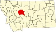
Tracy is an unincorporated community and census-designated place (CDP) in Cascade County, Montana, United States. It is in the east-central part of the county, in the valley of Sand Coulee Creek, a north-flowing tributary of the Missouri River. Tracy is bordered to the west by the community of Sand Coulee, and it is 12 miles (19 km) southeast of Great Falls.
Tracy was first listed as a CDP prior to the 2020 census.[2]
References[]
- ^ "2020 U.S. Gazetteer Files – Montana". United States Census Bureau. Retrieved June 9, 2021.
- ^ a b c "Tracy Census Designated Place". Geographic Names Information System. United States Geological Survey.
Categories:
- Census-designated places in Cascade County, Montana
- Census-designated places in Montana
- Montana geography stubs


