Trans-Ili Alatau
| Ile Alatau | |
|---|---|
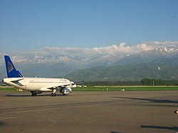 Ile Alatau as seen from Almaty International Airport | |
| Highest point | |
| Peak | Talgar Peak |
| Elevation | 4,973 m (16,316 ft) |
| Dimensions | |
| Length | 350 km (220 mi) E-W |
| Naming | |
| Native name | Ile Alatawy |
| Geography | |
| Countries | Kazakhstan and Kyrgyzstan |
| Range coordinates | 43°03′N 77°15′E / 43.05°N 77.25°ECoordinates: 43°03′N 77°15′E / 43.05°N 77.25°E |

Ile Alatau (Kazakh: Ile Alatawy, Іле Алаtауы), also spelt as Trans-Ili Alatau, etc., is a part of the Northern Tian Shan mountain system (ancient Mount Imeon) in Kazakhstan and Kyrgyzstan. It is the northernmost mountain range of Tian Shan stretching for about 350 km (220 mi) with a maximal elevation of 4,973 m (16,316 ft) (Talgar Peak). The term "Alatau" refers to a kind of mountain. The range is bounded from the north by the Ili Depression of the Ili River, hence the name.
The former capital of Kazakhstan, Almaty, is located at the foot of the range.
Peak Robeson[]
A mountain summit in the western Tian Shan and Ile Ala-Tau mountains is named after the late African-American entertainer and activist, Paul Robeson who advocated the U.S.-Soviet friendship.[1]
Footnotes[]
- ^ Paul Robeson: "The Great Forerunner -Editors of Freedomways", Freedomways Press, page 99
External links[]
- Ile and Kungey Alatau (in Russian)
| Authority control |
|---|
This Kazakhstan location article is a stub. You can help Wikipedia by . |
- Mountain ranges of Kazakhstan
- Mountain ranges of Kyrgyzstan
- Mountain ranges of the Tian Shan
- Kazakhstan geography stubs