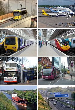
Transport in Manchester
 | |
| Overview | |
|---|---|
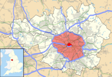
| Locale | Greater Manchester |
| Transit type | Buses, car, cycling, airport, commuter rail, tram, tram-train, high speed rail (proposed) |
| Number of lines | Bus routes: 600+ Tram: 8 Rail: 16 |
| Number of stations | Bus stops: 12,000 Tram stops: 99 Train stations: 101 |
| Daily ridership | 824,657 (2014)[1] |
| Operation | |
| Operator(s) | Transport for Greater Manchester (TfGM) |
The transport infrastructure of Greater Manchester is built up of numerous transport modes and forms an integral part of the structure of Greater Manchester and North West England – the most populated region outside of South East England which had approximately 301 million annual passenger journeys using either buses, planes, trains or trams in 2014.[2] Its position as a national city of commerce, education and cultural importance means the city has one of the largest and most thorough transport infrastructures which is heavily relied upon by its 2.8 million inhabitants in the Greater Manchester conurbation and further afield in the North West region. Public transport comes under the jurisdiction of Transport for Greater Manchester.
Greater Manchester has a higher percentage of the motorway network than any other county.[3] According to the Guinness Book of World Records, it has the most traffic lanes side by side (17), spread across several parallel carriageways – the M61 at Linnyshaw Moss, Greater Manchester,[4] close to the M60 interchange. The M60 is one of only two motorways in the UK designated as an 'Orbital Motorway', (the other being the M25 around London).
Greater Manchester still has an extensive citywide rail network compared with other British cities with over 200 tram and train stations - much of which dates from the Industrial Revolution. Two mainline termini (Piccadilly and Victoria) and four through mainline railway stations in the central area (Deansgate, Oxford Road, Salford Central and Salford Crescent) form the Manchester station group. Ultimately, Manchester sits at a rail bottleneck, and it is hoped investment in the proposed Northern Hub from 2013 to 2019 by Network Rail will alleviate this.
Manchester Airport is the third busiest airport in the United Kingdom after Heathrow and Gatwick. The city also has an extensive network of canal systems which converge into Manchester. The Manchester Ship Canal, built in 1894, was the largest ship canal in the world on opening and is incomparable to any other canal in the United Kingdom, which are mostly built for narrowboats and barges.
It was the first city in the United Kingdom to re-introduce trams to the streets with the 1992 opening of Manchester Metrolink, which is currently undergoing significant extension and is now the largest network in the UK, having surpassed the Tyne & Wear Metro.[5] As of August 2020 it has 99 stops, with the line to the Trafford Centre having opened in March 2020. No underground system exists in Manchester, however this was proposed on numerous occasions before the Metrolink tram system was built.
Additionally, to combat growing vehicular traffic and pollution, the city of Manchester actively encourages cycling and in recent years has introduced dedicated cycle lanes segregated from bus traffic on main thoroughfares into the city centre as well as a cycle sharing scheme delivered in collaboration with Mobike which was rolled out in 2017.
Ticketing[]

A variety of travelcards are available for passengers in Greater Manchester which are available under the System One banner. System One travelcards provide a daily, weekly, monthly or yearly pass and have varying options, offering combined multi-mode travel passes for bus, tram and train,
As of 2015, there is an ongoing move towards smartcard ticketing, similar to the Oyster Card in London. The scheme, called get me there to much local criticism. Metrolink will be the first to transition to smart ticketing in 2015 with bus services following in 2016 and train services in 2017.[6]
Air – Manchester Airport[]

Manchester Airport, formerly Manchester (Ringway) Airport, is the busiest airport outside London by a considerable margin with over double the passengers of its nearest non-London rival, Edinburgh Airport. With over 200 destinations, the Airport serves the most destinations of any airport in the United Kingdom and is viewed as the international flight hub for the whole of Northern England, North Wales and parts of the Midlands.[7] In 2008 the airport handled 22.4 million passengers but was badly affected by the Global Financial Crisis. The Airport gradually recovered and had become the fastest growing major airport in the United Kingdom by 2014 with 20.7 million passengers.
North American scheduled destinations served directly include New York City (JFK and Newark), Atlanta, Boston, Chicago, Houston, Las Vegas, Los Angeles, Miami, Orlando, Philadelphia, Washington D.C., Calgary, Toronto, Vancouver and Barbados.
Middle Eastern and Asian destinations include Abu Dhabi, Beijing, Doha, Dubai, Hong Kong, Islamabad, Karachi, Lahore and Singapore. There are also firm plans for non-stop services to Bangkok. Many European and domestic destinations are served. Manchester to London is one of the highest density airline routes within the UK and is one of the busiest domestic sectors in Europe, but is now experiencing serious competition from the improved railway link.
It is served by a dedicated railway station and a dedicated Metrolink line.
Road[]

The city of Manchester is the least car dependent city in the United Kingdom with 243 cars for every 1000 people but remains one of the most congested cities in Europe due to the dense nature of the Greater Manchester conurbation.[8] Research in 2008 suggested that Manchester is the fourth most congested city in Europe.[9] Another study in 2014 ranked Manchester as the most congested city in the United Kingdom outside London.[10]
In May 2017, Transport for Greater Manchester said that it was considering bringing in a revenue neutral £7.50 daily charge for drivers of polluting vehicles as part of plans for Clean Air Zones.[11] However Andy Burnham, Mayor of Greater Manchester, said that he would not introduce such a charge, although legal responsibility lies with councils rather than the Mayor.[12] In September 2018, the leaders of the local councils in Greater Manchester met to discuss charging the most polluting vehicles in a bid to improve the poor air quality in Manchester, which is responsible for around 1,000 premature deaths a year. Around 20% of private cars in the region, mostly pre-2015 diesels, and 70% of buses would be hit by the charge. The council leaders have a statutory responsibility to present plans reducing the amount of harmful nitrogen oxide in the air to legal limits to the Department of Environment, Food and Rural Affairs by December 31 2018 and must implement a Clean Air Zone unless a suitable alternative compliance strategy can be identified.[13] To meet the statutory requirements other cities such as Birmingham and Leeds have already decided to introduce Clean Air Zones while London is expanding its existing zones operating hours to 24 hours per day.
Greater Manchester and Greater London are the only two UK conurbations with a separately numbered orbital motorway (though it is possible to circumnavigate Birmingham via several differently numbered motorways). The Manchester ring road is called the M60. Unlike London's M25, the M60 actually runs within the Greater Manchester conurbation providing good inter-suburban links, rather than around the outside of the conurbation. The M60 has 27 junctions, numbered clockwise from junction 1 at Stockport in the south-east.
The M60 between junction 16 (Pendlebury/Kearsley) and junction 17 (Prestwich/Whitefield) is the second busiest section of road in the UK, after the M25 at junctions 13 & 14 (Heathrow). In 2010, it was decided that ramp metering would be used at numerous junctions on the M60 in an attempt to cut queues.[14]
The city also has an inner ring road. Part of this is the A57/A57(M) (known as The Mancunian Way), which runs south of the city centre, linking the western M602 (which spurs from the M60) to the eastern M60 and M67.
The other main motorways serving Manchester are the M56 (to the airport, Chester and the M6 southbound to Birmingham), the M61 (to Bolton, Preston and the M6 northbound to Lancaster), the M62 (west to Liverpool and east to Leeds and Kingston upon Hull), the M66 (to Bury) and the M67, which was originally planned as a route to Sheffield but was never completed. All of these motorways connect with the M60.
Rail[]

Piccadilly, Manchester's main terminus and busiest station


Victoria, Manchester's secondary station serving rail routes throughout Northern England


Oxford Road, an elevated station for passing rail services to Wales, Scotland and the Midlands


Deansgate, the smallest of the group with limited passing rail services

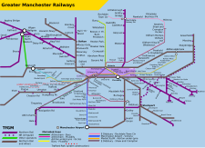
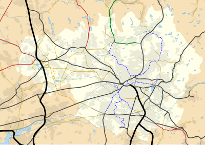
Map of rail and tram services in Greater Manchester

Manchester holds a pivotal position in railway history as a birthplace of passenger rail travel on the Liverpool and Manchester Railway, which opened in 1830. Railway links to London were established by 1842. By the turn of the 20th century, the city centre was encircled by large termini stations, which included:
- Manchester London Road (now Manchester Piccadilly)
- Manchester Victoria
- Manchester Central
- Manchester Exchange
- Manchester Mayfield
Cutbacks followed the Beeching Report in the 1960s, with Manchester Central, Manchester Exchange and Manchester Mayfield closing to passengers. All rail services in the city centre were then mainly concentrated on Manchester Piccadilly and Manchester Victoria as well as the smaller Oxford Road and Deansgate stations. Manchester Piccadilly was the busiest railway station in England outside London in terms of passengers in 2005–2006.[15]

Greater Manchester still has an extensive citywide railway network with two mainline termini (Piccadilly and Victoria) and four through mainline railway stations in the central area (Deansgate, Oxford Road, Salford Central and Salford Crescent). Rail use by passengers in Greater Manchester nearly doubled in the ten years from 2001 to 2011 and is predicted to rise by a further 54% from 2011 to 2020.[16] Its central location means the city acts as a key bypass for rail to cities such as Liverpool, Birmingham, Sheffield, Leeds, Newcastle, Glasgow and Edinburgh.[17] Avanti West Coast, CrossCountry, East Midlands Railway, Northern, TransPennine Express and Transport for Wales all operate trains through Manchester. Manchester sits at a rail bottleneck, and it is hoped investment in the Northern Hub scheme by Network Rail will alleviate this.[18]
There are several smaller stations around the city centre, including Oxford Road and Deansgate (formerly Knott Mill), and Salford Central across the Irwell in the City of Salford.
Piccadilly and Victoria are now linked by the city's Metrolink tram system and the Ordsall Chord, a short rail link that opened in 2017. The urban and suburban areas are covered by a sizeable network of railway lines, including to Ashton-under-Lyne, Bolton, Stockport and Wigan. Full timetables are from National Rail Enquiries. The commuter rail network within Greater Manchester (which numbers 101 stations) is the third most extensive (after Glasgow) outside Greater London and the South East.[19]
Future[]
In recent years, upgrades have been made to existing rail infrastructure in and around Manchester. Piccadilly was renovated prior to the Commonwealth Games in 2002 and has been rated as one of the best large stations in the country. From 1998 to 2008, the West Coast Main Line linking Manchester to Glasgow, Birmingham and London was upgraded reducing journey times but fell short of the targeted 155 mph top speed.
The Manchester hub report was published in 2010 by Network Rail, examining possibilities of how the rail network in Manchester could be improved amid large passenger growth to and from Manchester. Network Rail proposed a £560 million scheme which would alleviate rail bottlenecks across northern England in 2011. Full funding for the project, now called the Northern Hub was confirmed in July 2012, as part of the Government's High Level Output Specification (HLOS) for the rail industry for 2014–2019.[20]
Two new through platforms are planned as part of the Northern Hub project however in 2017 the construction was not confirmed.[21] At present there are twelve terminating platforms but just two through platforms. Congestion is common at peak times and trains often incur delays for following trains down the line at Oxford Road. The new proposals will provide up to 700 more trains per day with space for 44 million more people to travel by train each year.
Victoria station has undergone a series of upgrades. The station was rated as the worst in the UK following a 2009 study and plans for a new roof have been in place since 1996. Work commenced in April 2013. Installation of the new £17 million ETFE roof began on 5 May 2014 and work on the station was completed in August 2015.[22][23] Part of the new roof collapsed, injuring some people in October 2016[24]
Tram – Metrolink[]

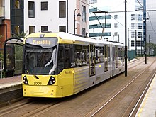

Manchester has an urban light rail system called Metrolink. Operated by a Keolis / Amey consortium, Metrolink links the city centre to Altrincham, Ashton-under-Lyne, Bury, East Didsbury, Eccles, Manchester Airport, Rochdale and Trafford Centre. It is a high-frequency service, with trams running every 6–12 minutes. It carried 30 million passengers in 2014.[26]
Trams first appeared on the streets of Manchester in 1877 and by 1901 were taken over and electrified by Manchester Corporation Tramways. The system grew to the third largest in the UK but was abandoned in 1949. Proposals for a light rail system in the city grew from a 1970s proposal by SELNEC to build three rapid transit lines. This idea was superseded by the Picc-Vic project but light-rail was resurrected again in the 1980s; it was these proposals which led to the creation of the Metrolink, the first routes of which were opened in 1992.
Plans to extend Metrolink were reinstated after an election-time u-turn by the Labour Government which had rejected the plans months earlier, despite years of support. The Greater Manchester Passenger Transport Executive led the fight to ensure that the extensions be built, with significant support from local councils and communities and Manchester City Council.[27] In July 2006, the government announced a major extension to the Metrolink system, which is intended to form the first phase of the so-called 'big bang' expansion. If the eventual desired system is completed, passenger numbers are predicted to more than double to an estimated 50 million per year.
Since the initial approval of the system from the public, local and national government, and environmental groups, Metrolink has become something of a victim of its own popularity.[28] Many routes are extremely busy, especially at peak times, and prices have risen at far above the rate of inflation. The network has also gained a reputation for being somewhat unreliable.[29] In 2011, Stagecoach Group who operated the Metrolink under contract to Transport for Greater Manchester, sold the contract to the RATP Group.[30]
Bus[]
This section needs additional citations for verification. (June 2017) |

Greater Manchester has an extensive bus network managed by Transport for Greater Manchester,[31] including a night bus service which is one of the most extensive outside London.[32] The bus network had an annual ridership of 225 million passengers in 2014 [26]
Buses are operated by companies including Stagecoach Manchester (incorporating the lower-cost Magic Bus), Go North West, Diamond North West, First Greater Manchester and Arriva North West.
The major routes, with high passenger volumes, include Oxford Road/Wilmslow Road, one of the busiest bus routes in Europe, bringing large numbers of students and commuters from the South Manchester suburbs of Didsbury, Fallowfield, Rusholme and Withington and to the university buildings and city centre. Tickets for some services on this route are cheaper than on most other commercial routes and special week tickets can be bought only for services on this corridor. Tickets on other routes that are not as commercially attractive, with smaller passenger volumes, and which are less well provided for, have significantly higher prices for single, daily and weekly tickets. Further major bus corridors include Rochdale Road between Manchester and Middleton, Oldham Road between Manchester and Failsworth, Hyde Road between Manchester and Gorton, Princess Road towards Wythenshawe and the A6 corridor in Salford.
The majority of bus services in South Manchester are provided by Stagecoach Manchester including the 192 service which connects Manchester and Stockport, which is reputed to be the busiest bus route in the country. Stagecoach also provides services from Manchester city centre to the airport. This includes the 43 service, the only 24-hour bus service in Greater Manchester, which also serves the Oxford Road/Wilmslow Road corridor.
Go North West is the main operator in the North of Manchester with routes extending to Warrington, Worsley & Bury It also operates Free Bus services that link important points in the city centre such as Piccadilly, Victoria and Oxford Road stations with Chinatown, Deansgate, Salford Central, and Albert Square. These services are very successful and therefore often busy. There are two routes, numbered 1 and 2. They run every 5–10 minutes and complement the Metrolink and National Rail services. Those arriving at Manchester Piccadilly bus station and needing to take a train from Piccadilly, less than half a mile (500 metres) away, can choose either the Metrolink, the free bus, or walk.
First Greater Manchester previously operated a number of 'overground' services, high frequency colour-coded services connecting Manchester with many large towns around the conurbation including Bolton, Bury, Oldham and Rochdale. The colour-coded branding has largely been dropped since the start of the 2010s and the colours are only used to advertise specific routes. First operated the 'Night Bus' on many of the most busy routes but these services, namely the 8 service from Bolton-Manchester, but this has been dropped and the last services on most routes is on or around 12am. At their height, First Greater Manchester operated on high frequency route between Bury-Manchester, the 135 service, which operates every six to ten minutes is the competing bus route with Metrolink's Bury Line. This service was operated using only articulated buses, but this has ceased in recent years and the buses moved on to other services such as the 471 on its route from Bolton-Rochdale via Bury, they have since been withdrawn entirely.
Manchester's principal bus station used mainly for services on the south side of the city is at Piccadilly Gardens, which is served primarily by Stagecoach Manchester and also by Metrolink. Shudehill Interchange caters for routes mainly on the north side of the city, which is within walking distance of Victoria and is mainly used by Go North West. Megabus use Shudehill for their National Coach services. Long-distance coaches, operated mainly by National Express, serve the Manchester Chorlton Street coach station at Chorlton Street.
Greater Manchester bus stops were replaced over a five-year period. The older bus stop flags were based on a nationally adopted design featuring a single decker bus and were used over the entire country with the exception of London. Following bus deregulation there was no compulsion to use the national symbol and several passenger transport executives like West Yorkshire Metro's Metro and Merseyside adopted a new bus stop flag design featuring their capital M logo. GMPTE inherited their own M shaped logo and also began to use it on the glass back of bus shelters from the late 1990s. They have subsequently introduced this to a new design for bus stop flags – firstly used in 2002 on high priority routes – and now being erected across the entire GMPTE area.
In 2011, with a change of name and remit of the transport authority, these were replaced by a modified "M" design.
In 2021, during the COVID-19 pandemic, several hundred bus drivers in Manchester working for Go North West went on strike for two months.
Waterborne[]

One legacy of the industrial revolution is an extensive network of canals: the Manchester, Bolton & Bury Canal, Rochdale Canal, Bridgewater Canal, Ashton Canal, and the Leigh Branch of the Leeds & Liverpool Canal. Most of these canals were constructed for transporting commodities such as coal and iron at a time when vehicular transport was not present. Most of these canals are now used for recreation.
The Manchester Ship Canal is the only purpose built-ship canal in the United Kingdom, and upon opening in 1894 was the largest ship navigation canal in the world allowing for ships with a length of up to 600 feet to navigate its 36-mile route. The deteriorating state of the Irwell Mersey Navigation and the excessive dues charged by the Port of Liverpool fuelled influential Mancunian businessmen such as Daniel Adamson to find a solution, and consequently the idea of a ship canal was formed. The ship canal never became the success its patrons had wished, and traffic peaked in the 1960s. The canal fell into a state of disrepair, but since the 1990s there has been renewed efforts to use the canal more as a transport route. Freight is once again being carried on the canal.[33] The ship canal is also used for leisure,[34] and a scheme to use canal and River Irwell as a waterway to transport commuters has also been envisaged.[35] A trip from MediaCityUK at Salford Quays to Spinningfields in Manchester city centre it is hoped would take 15 to 20 minutes.[36] Manchester Water Taxis ran boats from the Trafford Centre and Old Trafford to the city centre, taking around an hour from the Trafford centre to the city centre and 20 minutes from Old Trafford to the city centre.[37] These came to an end in June 2018, with the company citing a lack of proper landings for customers putting people off [38]
Proposed[]
Underground metro[]
An underground system does not exist in Manchester but there was a proposal to create an underground system in the 1970s. The Picc-Vic tunnel was proposed to link Piccadilly and Victoria stations with a number of stations between both. The proposal was shelved due to cost and was deemed impractical with Manchester's network of tunnels and building basements from the Victorian era creating construction difficulties. The Guardian exchange which doubles up as a nuclear bunker also has a series of interconnected tunnels running under Manchester which total over six miles in length and 60 metres (180 feet) in depth in certain areas.[39]
Excavation work under the Manchester Arndale for this project began in the 1970s, but was soon abandoned due to costs and rumours of 'subterranean obstacles'. Other abandoned tunnels hidden for decades have recently been discovered including a 460-metre canal tunnel from the River Irwell to the canal system [40][41][42]
Manchester Public Transportation Statistics[]
The average amount of time people spend commuting with public transit in Manchester, for example to and from work, on a weekday is 89 min. 31% of public transit riders, ride for more than 2 hours every day. The average amount of time people wait at a stop or station for public transit is 18 min, while 28.% of riders wait for over 20 minutes on average every day. The average distance people usually ride in a single trip with public transit is 7.2 km, while 12% travel for over 12 km in a single direction.[43]
See also[]
- Cycling in Manchester
- Category:Transport in Greater Manchester
- Category:History of transport in Greater Manchester
References[]
- ^ "Facts & Figures". Transport for Greater Manchester (TfGM). Archived from the original on 4 July 2015. Retrieved 26 November 2014.
- ^ "Transport for Greater Manchester Facts & Figures". tfgm.com. Transport for Greater Manchester 2015. Archived from the original on 4 July 2015. Retrieved 10 October 2015.
- ^ The Metropolitan County of Greater Manchester has the most extensive motorway network in the United Kingdom. Archived 9 October 2006 at the Wayback Machine Oldham College -About Manchester URL accessed 28 June 2007
- ^ British Roads Database www.cbrd.co.uk URL accessed 28 June 2007
- ^ "Future extensions". Transport for Greater Manchester. Retrieved 19 May 2013.
By 2014 the expansion programme will mean Greater Manchester will have the largest tram network in the UK.
- ^ Manchester bus passengers benefit from multi-operator smart ticketing Euro Transport Magazine 18 November 2015
- ^ Campbell, Scott (10 April 2014). "China route highlights Manchester's 'northern hub' aim". The Telegraph. Retrieved 11 April 2014.
- ^ "Fareham named as Britain's most car dependent town". The Telegraph. 24 July 2014. Retrieved 28 July 2014.
- ^ "Europe's Most Congested Cities". Forbes. 21 April 2008. Retrieved 6 September 2008.
- ^ "Greater Manchester one of the most congested road networks in Europe". Manchester Evening News. 5 March 2014. Retrieved 28 July 2014.
- ^ "Greater Manchester congestion charge considered". 9 May 2017 – via www.bbc.co.uk.
- ^ "Greater Manchester congestion charge: Mayor Andy Burnham rejects plan". 11 May 2017 – via www.bbc.co.uk.
- ^ Williams, Jennifer (7 October 2018). "Drivers could be charged to go into Manchester city centre". Manchester Evening News.
- ^ "Bright idea to cut M60 queues". menmedia.co.uk. 25 August 2010. Retrieved 23 October 2010.
- ^ "Passenger Numbers 2005–06". Retrieved 1 October 2007.
- ^ "The Missing Link: Rail line between Manchester Piccadilly and Victoria stations to boost jobs and business". Manchester Evening News. 5 April 2011.
- ^ "Manchester Hub Study". Steer Davies Greave. August 2007. Archived from the original on 4 December 2010.
- ^ "Manchester transport schemes vital to regional economy". Institution of Civil Engineers. 3 February 2012. Retrieved 16 March 2012.[permanent dead link]
- ^ [1]
- ^ "Northern Hub rail plans put to government". BBC News. 26 September 2011. Retrieved 15 March 2012.
- ^ Cox, Charlotte (8 February 2017). "'Crass stupidity' delays plan for new Piccadilly platforms". Manchester Evening News.
- ^ "Manchester Victoria station's restoration works start". BBC News. 9 April 2013. Retrieved 9 April 2013.
- ^ "Manchester Victoria upgrades to be finished this month". www.railtechnologymagazine.com.
- ^ "Two hurt in Manchester Victoria Station roof collapse". 18 October 2016 – via www.bbc.co.uk.
- ^ "Light rail and tram statistics (LRT)". GOV.UK.
- ^ Jump up to: a b "Transport for Greater Manchester Facts & Figures". tfgm.com. Transport for Greater Manchester. Archived from the original on 4 July 2015. Retrieved 10 October 2015.
- ^ "Get our Metrolink back on track Archived 15 April 2007 at the Wayback Machine", Manchester City Council, 25 November 2005; Retrieved 14 May 2006.
- ^ "Metrolink: are you being taken for a ride?". BBC. June 2003. Retrieved 11 December 2011.
- ^ "Metrolink scores 6/10 (and that's according to the bosses)". Manchester Confidential. 22 February 2010. Archived from the original on 5 April 2012. Retrieved 11 December 2011.
- ^ RATP buys Manchester Metrolink operator Railway Gazette International 2 August 2011
- ^ Maps of bus routes and a public transport journey planner for the Greater Manchester are on the TFGM website.
- ^ "Archived copy". Archived from the original on 16 November 2008. Retrieved 23 May 2009.CS1 maint: archived copy as title (link)
- ^ "Manchester Ship Canal – Introduction". Peel Ports Group. Retrieved 16 March 2012.
- ^ "Manchester Ship Canal Cruises". Mersey Ferries. Archived from the original on 18 March 2012. Retrieved 12 March 2012.
- ^ "Go to work in a waxi: Plans for water taxis on River Irwell". Manchester Evening News. 9 December 2010.
- ^ "Water taxis could get green light this month". Manchester Confidential. 23 September 2011. Archived from the original on 1 October 2011.
- ^ Slater, Chris (8 November 2016). "Watch: The route taken by Manchester's new water taxis". Manchester Evening News. Retrieved 28 August 2020.
- ^ Heward, Emily (22 June 2018). "Manchester's water taxi service runs aground after two years". Manchester Evening News.
- ^ Schofield, Jonathan (7 August 2012). "The Good, The Standard, The Ugly: Dial House, Salford". Manchester Confidential. Archived from the original on 19 October 2012. Retrieved 26 October 2012.
- ^ "Manchester Salford Junction Canal – Subterranea Britannica". www.subbrit.org.uk.
- ^ "Manchester and Salford Junction Canal". Pennine Waterways. Retrieved 26 October 2012.
- ^ Wainwright, Martin (14 March 2012). "Manchester's tube train that never was". Retrieved 26 October 2012.
- ^ "Manchester Public Transportation Statistics". Global Public Transit Index by Moovit. Retrieved 19 June 2017.
 Material was copied from this source, which is available under a Creative Commons Attribution 4.0 International License.
External links[]
| show Railway stations in Greater Manchester |
|---|
| show Closed railway stations in Greater Manchester |
|---|
| show Transport in Greater Manchester |
|---|

- Transport in Manchester