Travis Triangle
Travis Triangle is a narrow green space in the Murray Hill/Flushing neighborhoods of Queens, New York City. It is formed by the separation of Murray Street and Murray Lane, both of which were named after the Murray family, which owned land on the site of these streets from the late colonial period through the early 19th century. In 1932, New York City's Board of Aldermen passed a resolution to name this site Travis Triangle in honor of local American Civil War veteran Ira Underhill Travis (1839-1921),[1] who fought under the name Ira Wilson, in the 11th New York Volunteer Infantry Regiment also known as Colonel Elmer E. Ellsworth’s Zouaves.[2]
In the incident at Marshall House Inn during the Union Army's occupation of Alexandria, Virginia, his commander was killed after removing a Confederate flag. Travis kept a piece of the flag as a souvenir for his family[3] In July 1861, Travis received a bullet wound in his shoulder in the First Battle of Manassas. The bullet remained lodged in his shoulder for the rest of his life. Travis was buried at Flushing Cemetery.[4]
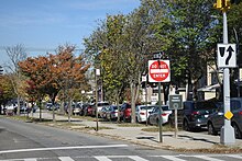
With the arrival of the subway to Flushing in 1928, the neighborhood expanded to the north and east and parks were built to accommodate the new residents. Parcels that were too small to develop, such as this site, were designated as green spaces maintained by the city's Parks Department.
The park contains plots for 24 trees and a bench on its northern side. Continuing north, Murray Lane gradually narrows, taking on the appearance of a countryside lane, having changed little as the surrounding neighborhood transformed over a century from farmland towards residential.
References[]
- ^ Board of Aldermen Resolution 175 of April 19, 1932
- ^ Giaimo, Cara (March 29, 2016). "The Civil War Fighters Who Tempted Fate With North African Fashion". Atlas Obscura. Retrieved 2016-03-29.
- ^ Shane, Ken (August 2, 2012). "Significant piece of Civil War history found in island basement: Story of Confederate flag featured on PBS program". Jamestown Press. Archived from the original on October 4, 2018.
- ^ Nicolson, Jill "Ira Underhill Travis, Sr." Find a Grave April 18, 2013 https://www.findagrave.com/cgi-bin/fg.cgi?page=gr&GRid=108717483
External links[]
Coordinates: 40°46′01″N 73°48′47″W / 40.766853°N 73.813088°W

- Parks in Queens, New York
- Flushing, Queens
- People of New York (state) in the American Civil War
- Squares in Queens, New York