Trent Bridge (bridge)
Trent Bridge | |
|---|---|
 View of Trent Bridge from the bank of the River Trent, West Bridgford | |
| Coordinates | 52°56′18.4″N 1°08′10.9″W / 52.938444°N 1.136361°WCoordinates: 52°56′18.4″N 1°08′10.9″W / 52.938444°N 1.136361°W |
| Carries | Road traffic ( A60 , single carriageway) |
| Crosses | River Trent |
| Locale | Nottingham, Nottinghamshire, England |
| Heritage status | Grade II listed |
| Characteristics | |
| Material | Iron and stone |
| Width | 40 feet (12 m) |
| Longest span | 100 feet (30 m) |
| History | |
| Designer | Marriott Ogle Tarbotton |
| Constructed by | Andrew Handyside and Company |
| Construction start | 1868 |
| Construction end | 1871 |
| Location | |
 | |

Trent Bridge is an iron and stone road bridge across the River Trent in Nottingham, England. It is the principal river crossing for entrance to the city from the south, although the upstream Clifton Bridge is both larger and busier.
History[]
Medieval bridge[]
The first bridge is thought to have been constructed on the site in 920. A second bridge which was started in 1156 had more than 20 stone arches and a chapel dedicated to St. James[1] at one end. It was maintained by a religious organisation. On 21 February 1551 the responsibility for repair passed to Nottingham Corporation, through a Royal Charter which created the Bridge Estate.
It was known as Hethbeth bridge, Heath-beth bridge, or Heck-beck bridge.[2]
This bridge was damaged by floods several times, and the northern half was washed away in 1683. The repaired bridge had fifteen arches across the river and flood areas, giving openings covering 347 ft in a total length of 538 ft.[3] Although it was repaired, the foundations had become unsafe and a project to replace it was started in the 1860s.
Modern bridge[]
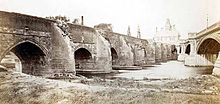
The bridge was designed by Marriott Ogle Tarbotton.[4] Construction started in 1868 and was completed in 1871 by Derbyshire iron maker, Andrew Handyside. The general contractor was Benton and Woodiwiss of Derby. It was completed for a cost of £30,000 (equivalent to £2,813,922 as of 2019).[5] There were three main cast iron arch spans each 100 feet (30 m) braced by wrought iron girders. The width between the parapets was 40 feet (12 m). It is a Grade II listed building.[6] The carving on the bridge was executed by Mawer and Ingle of Leeds.[7]
The new Trent Bridge formed part of a series of works along the banks of the river to improve flood defences by the construction of stepped, stone embankments.
Between 1924 and 1926 the bridge was widened to 80 ft by the Cleveland Bridge & Engineering Company.[3]
Bridge Estate[]

The Bridge Estate was created by a Royal Charter of King Edward VI on 21 February 1551 with as Trustee. The objective was to provide funds to maintain and repair the Bridge.
In 1882 the funds exceed the requirement of the objective, and three new objectives were agreed:
- Provide for the efficient maintenance and repair of Trent Bridge and the approaches to it.
- To set up a contingency fund for the possible construction of such new bridge or bridges over the River Trent as may be found necessary or desirable.
- The residue of such income is to be applied as the Trustee thinks best for the improvement of the City of Nottingham and the public benefit of its inhabitants.
In 1945 the Bridge Estate was registered as Charity 220716 with the Charity Commissioners.
Flood marks[]
| showFloods levels at Trent Bridge[8] |
|---|
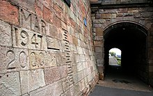

On the northern abutment of the bridge, the high water marks reached by floods since 1852 have been carved into the stonework. This practice was started during the period when the Hethbeth bridge still existed, and those earlier marks were transferred onto the new bridge. To enable a comparison to be made with the peak levels, a graduated series of heights in feet above sea level has also been added.[8][9][10]
The highest flood mark is for the October 1875 flood, but the larger 1795 Candlemas flood, has been attributed with a height at the bridge of 24.55 metres (80.5 ft). Normal water level which is controlled by Holmes Sluices some 4 kilometres (2.5 mi) downstream, is 20.7 metres (68 ft).[8][9][11]
Fame and popular culture[]
The bridge is one of Nottingham's most famous landmarks and sits at the heart of Nottingham's sporting district. The bridge lends its name to the nearby Nottinghamshire County Cricket Club Trent Bridge stadium, one of England's biggest and most famous cricket grounds. Nottingham Forest FC's City Ground stadium and Notts County FC's Meadow Lane stadium are nearby. The bridge has also been used in as the backdrop for the regional BBC East Midlands Today and ITV Central News.[citation needed]
The Riverbank public house overlooks the bridge in its former tollhouse.[citation needed]
In December 2002, the Nottingham Princess river cruise boat crashed into the central column of the bridge when it lost control in strong currents.[11]
See also[]
References[]
- ^ Bridges, law and power in medieval England, 700-1400. Alan Cooper
- ^ History and antiquities of Nottingham. James Orange
- ^ Jump up to: a b Labrum, E. A. (1993). Civil engineering heritage, eastern and central England. Thomas Telford. ISBN 978-0727719706.
- ^ Nottingham: an illustrated history By J. V. Beckett, Ken Brand
- ^ UK Retail Price Index inflation figures are based on data from Clark, Gregory (2017). "The Annual RPI and Average Earnings for Britain, 1209 to Present (New Series)". MeasuringWorth. Retrieved 2 February 2020.
- ^ Historic England. "TRENT BRIDGE (1045636)". National Heritage List for England. Retrieved 15 June 2015.
- ^ Bedfordshire Mercury Bedfordshire, England Saturday 29 July 1871 p6 col5: "Opening of a new bridge"
- ^ Jump up to: a b c "Nottingham Left Bank Flood Alleviation Scheme Flood Risk Assessment" (PDF). broxtowe.gov.uk. 2001. Retrieved 10 May 2013.
- ^ Jump up to: a b Stone, Richard (2005). River Trent. Phillimore. p. 120. ISBN 1860773567.
- ^ Macdonald, Neil (2012). "Reassessing flood frequency for the River Trent through the inclusion of historical flood information since AD1320" (PDF). cost-floodfreq.eu. Retrieved 10 May 2013.[permanent dead link]
- ^ Jump up to: a b "Report on the investigation of Nottingham Princess striking Trent Bridge Nottingham" (PDF). maib.gov.uk. 2003. Retrieved 1 June 2013.
| Wikimedia Commons has media related to Trent Bridge, Nottingham. |
| show Places of interest in Nottingham |
|---|

- Bridges in Nottingham
- Bridges across the River Trent
- Grade II listed buildings in Nottinghamshire
- Bridges completed in 1871
- Former toll bridges in England
- Grade II listed bridges
- West Bridgford