Trentham, New Zealand
Trentham | |
|---|---|
 View looking northeast from Silverstream, with Trentham Racecourse in the centre and Trentham Army Camp at right | |
 | |
| Coordinates: 41°08′S 175°02′E / 41.13°S 175.04°ECoordinates: 41°08′S 175°02′E / 41.13°S 175.04°E | |
| Country | New Zealand |
| Island | North Island |
| Region | Wellington |
| City | Upper Hutt |
| Area | |
| • Total | 11.36 km2 (4.39 sq mi) |
| Population (June 2021)[2] | |
| • Total | 8,910 |
| • Density | 780/km2 (2,000/sq mi) |

Trentham (/ˈtrɛnθəm/) is the most populous suburb of Upper Hutt, a city in the Wellington region of New Zealand. The suburb is located in a widening of the Hutt Valley, five kilometres to the southwest of the Upper Hutt city centre.
The suburb includes the Trentham Racecourse, the base of the Wellington Racing Club, the site of Hutt International Boys' School, and the Trentham Railway Station.[3]
The Trentham Military Camp was used extensively for training soldiers in preparation for World War I and World War II.[4][5] It is still a base for the New Zealand Defence Force.
A General Motors-Holden assembly plant operated in Trentham between 1967 and 1990.[6]
History[]
The area was settled in the 1840s.[3]
The name "Trentham" was initially given by Richard Barton, the first European Settler in the area, in honour of his former employer, the Duke of Sutherland. One of the Duke of Sutherland's subsidiary titles was Viscount Trentham, of Trentham in the County of Stafford.
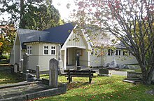
The Barton family memory lives on in the area, with Barton Road, Barton Avenue and an area of native trees called Barton's Bush, which is within the reserve now known as Trentham Memorial Park. Richard Barton was interred in the grounds of St John's Church, and there are also memorials to him in the form of brass plaques within the Church building.[7]
Demographics[]
Trentham, comprising the statistical areas of Poets Block, Brentwood (Upper Hutt City), Trentham North and Trentham South, covers 11.36 km2 (4.39 sq mi).[1] It had an estimated population of 8,910 as of June 2021, with a population density of 784 people per km2.
| Year | Pop. | ±% p.a. |
|---|---|---|
| 2006 | 8,265 | — |
| 2013 | 8,529 | +0.45% |
| 2018 | 9,606 | +2.41% |
| Source: [8] | ||
Trentham had a population of 9,606 at the 2018 New Zealand census, an increase of 1,077 people (12.6%) since the 2013 census, and an increase of 1,341 people (16.2%) since the 2006 census. There were 3,330 households. There were 5,040 males and 4,560 females, giving a sex ratio of 1.11 males per female, with 1,674 people (17.4%) aged under 15 years, 2,010 (20.9%) aged 15 to 29, 4,308 (44.8%) aged 30 to 64, and 1,614 (16.8%) aged 65 or older.
Ethnicities were 72.7% European/Pākehā, 21.1% Māori, 7.2% Pacific peoples, 10.7% Asian, and 3.3% other ethnicities (totals add to more than 100% since people could identify with multiple ethnicities).
The proportion of people born overseas was 21.2%, compared with 27.1% nationally.
Although some people objected to giving their religion, 44.3% had no religion, 39.3% were Christian, 2.6% were Hindu, 0.7% were Muslim, 1.1% were Buddhist and 5.1% had other religions.
Of those at least 15 years old, 1,317 (16.6%) people had a bachelor or higher degree, and 1,563 (19.7%) people had no formal qualifications. The employment status of those at least 15 was that 3,618 (45.6%) people were employed full-time, 888 (11.2%) were part-time, and 363 (4.6%) were unemployed.[8]
| Name | Population | Households | Median age | Median income |
|---|---|---|---|---|
| Poets Block | 2,472 | 891 | 36 years | $34,700[9] |
| Brentwood (Upper Hutt City) | 2,241 | 780 | 35 years | $31,400[10] |
| Trentham North | 3,084 | 1,218 | 39 years | $28,800[11] |
| Trentham South | 1,809 | 441 | 41.4 years | $16,700[12] |
| New Zealand | 37.4 years | $31,800 |
Education[]
Trentham School is a co-educational state primary school for Year 1 to 6 students,[13][14] with a roll of 410 as of November 2021.[15]
Brentwood School, a co-educational state primary school for year 1 to 6 students, opened in 1955 to deal with the overflow from Trentham School.[16] The school was closed in 2004 and merged with Trentham School.[17]
Fergusson Intermediate is a co-educational state intermediate school for Year 7 to 8 students,[18][19] with a roll of 384.[20]
Upper Hutt College is a co-educational state primary school for Year 9 to 15 students,[21] with a roll of 960.[22] It was founded in 1962.[23]
Hutt International Boys' School is a state-integrated Christian secondary school for Year 7 to 13 students,[24] with a roll of 646.[25] It was founded in 1991.[26]
References[]
- ^ a b "ArcGIS Web Application". statsnz.maps.arcgis.com. Retrieved 3 June 2021.
- ^ "Population estimate tables - NZ.Stat". Statistics New Zealand. Retrieved 22 October 2021.
- ^ a b Pinehaven Progressive Association - History
- ^ Photo of Trentham Camp 1914-1918
- ^ Photo of Trentham Camp 1939
- ^ Colin Williams (18 November 2015). "Upper Hutt's former car assembly plant sold to Weta film group". Upper Hutt Leader/Stuff.co.nz.
- ^ "Our First Hundred Years... - A History of St John's Anglican Church, published in 1961 on behalf of the Parish of Trentham". St John's Anglican Church History. Archived from the original on 22 January 2016. Retrieved 4 March 2016.
- ^ a b "Statistical area 1 dataset for 2018 Census". Statistics New Zealand. March 2020. Poets Block (241600), Brentwood (Upper Hutt City) (241700), Trentham North (242000) and Trentham South (242200).
- ^ 2018 Census place summary: Poets Block
- ^ 2018 Census place summary: Brentwood (Upper Hutt City)
- ^ 2018 Census place summary: Trentham North
- ^ 2018 Census place summary: Trentham South
- ^ "Trentham School Official School Website". trentham.school.nz.
- ^ "Trentham School Ministry of Education School Profile". educationcounts.govt.nz. Ministry of Education.
- ^ "Trentham School Education Review Office Report". ero.govt.nz. Education Review Office.
- ^ https://uhcl.recollect.co.nz/nodes/view/26003
- ^ https://www.beehive.govt.nz/release/final-decision-upper-hutt-review
- ^ "Fergusson Intermediate Official School Website". fergusson.school.nz.
- ^ "Fergusson Intermediate Ministry of Education School Profile". educationcounts.govt.nz. Ministry of Education.
- ^ "Fergusson Intermediate Education Review Office Report". ero.govt.nz. Education Review Office.
- ^ "Upper Hutt College Education Review Office Report". ero.govt.nz. Education Review Office.
- ^ "Upper Hutt College Ministry of Education School Profile". educationcounts.govt.nz. Ministry of Education.
- ^ "Upper Hutt College Official School Website". upperhutt.school.nz.
- ^ "Hutt International Boys' School Education Review Office Report". ero.govt.nz. Education Review Office.
- ^ "Hutt International Boys' School Ministry of Education School Profile". educationcounts.govt.nz. Ministry of Education.
- ^ "Hutt International Boys' School Official School Website". hibs.school.nz.
- Suburbs of Upper Hutt
- Populated places on Te Awa Kairangi / Hutt River