Triglav Bistrica
| Triglav Bistrica | |
|---|---|
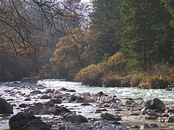
 Mist on the Triglav Bistrica | |
| Location | |
| Country | Slovenia |
| Physical characteristics | |
| Source | |
| • location | Below the north face of Mount Triglav, Julian Alps |
| • coordinates | 46°24′42″N 13°50′47″E / 46.41167°N 13.84639°E |
| Mouth | |
• location | Sava Dolinka, near Mojstrana |
• coordinates | 46°27′45″N 13°56′40″E / 46.46250°N 13.94444°ECoordinates: 46°27′45″N 13°56′40″E / 46.46250°N 13.94444°E |
| Length | 10 km (6.2 mi) |
| Basin features | |
| Progression | Sava→ Danube→ Black Sea |
The Triglav Bistrica (Slovene: Triglavska Bistrica, also simply known as the Bistrica)[1] is a stream that flows through the glacial Vrata Valley southwest of Mojstrana, Slovenia. Its source is below the north face of Mount Triglav in the blind Bukovlje Valley, and it flows past the Aljaž Lodge.[2] In addition to several intermittent tributaries with a flashy character, it also has three constant tributaries, all of them flowing from valleys below the east slope of Mount Škrlatica: Dry Creek (Suhi potok), Red Creek (Rdeči potok), and Peričnik Creek. The Triglav Bistrica empties into the Sava Dolinka at Mojstrana. It falls 400 meters (1,300 ft) during its approximately 10-kilometer (6.2 mi) course.
References[]
- ^ Mauro Hrvatin; Matija Zorn (2018). "Recentne spremembe rečnih pretokov in pretočnih režimov v Julijskih alpah". In Zorn, Matija; Mikša, Peter; Lačen Benedičič, Irena; Ogrin, Matej; Kunstelj, Ana Marija (eds.). Triglav 240. Ljubljana: ZRC SAZU. p. 124.
- ^ Carey, Justi; Clark, Roy (2019). The Slovene Mountain Trail: Slovenska planinska pot. Kendal, UK: Cicerone. p. 122.
External links[]
 Media related to Triglav Bistrica at Wikimedia Commons
- The Triglav Bistrica at Geopedia
Categories:
- Tributaries of the Sava
- Rivers of Upper Carniola
- Rivers of the Julian Alps
- Sava

