Trois-Monts
show This article may be expanded with text translated from the corresponding article in French. (December 2008) Click [show] for important translation instructions. |
Trois-Monts | |
|---|---|
Part of Montillières-sur-Orne | |
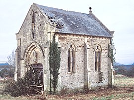 The chapel in Trois-Monts | |
show Location of Trois-Monts | |
 Trois-Monts | |
| Coordinates: 49°02′52″N 0°28′44″W / 49.0478°N 0.4789°WCoordinates: 49°02′52″N 0°28′44″W / 49.0478°N 0.4789°W | |
| Country | France |
| Region | Normandy |
| Department | Calvados |
| Arrondissement | Caen |
| Canton | Thury-Harcourt |
| Commune | Montillières-sur-Orne |
| Area 1 | 7.04 km2 (2.72 sq mi) |
| Population (2016)[1] | 427 |
| • Density | 61/km2 (160/sq mi) |
| Time zone | UTC+01:00 (CET) |
| • Summer (DST) | UTC+02:00 (CEST) |
| Postal code | 14210 |
| Elevation | 12–159 m (39–522 ft) (avg. 100 m or 330 ft) |
| 1 French Land Register data, which excludes lakes, ponds, glaciers > 1 km2 (0.386 sq mi or 247 acres) and river estuaries. | |


Trois-Monts (pronounced [tʁwɑ mɔ̃]; French for 'three-mountains') is a former commune in the Calvados department in the Normandy region in northwestern France. On 1 January 2019, it was merged into the new commune Montillières-sur-Orne.[2]
Population[]
| Year | Pop. | ±% |
|---|---|---|
| 1962 | 193 | — |
| 1968 | 180 | −6.7% |
| 1975 | 199 | +10.6% |
| 1982 | 278 | +39.7% |
| 1990 | 314 | +12.9% |
| 1999 | 338 | +7.6% |
| 2008 | 369 | +9.2% |
See also[]
- Communes of the Calvados department
References[]
- ^ Téléchargement du fichier d'ensemble des populations légales en 2016, INSEE
- ^ Arrêté préfectoral 28 September 2018, p. 91 (in French)
| Wikimedia Commons has media related to Trois-Monts. |
This Calvados geographical article is a stub. You can help Wikipedia by . |
Categories:
- Former communes of Calvados (department)
- Populated places disestablished in 2019
- Calvados (department) geography stubs