Tronfjell
| Tronfjell | |
|---|---|
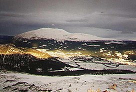 Tronfjell with Alvdal in front. | |
| Highest point | |
| Elevation | 1,666 m (5,466 ft) |
| Prominence | 1,007 m |
| Coordinates | 62°10′29.07″N 10°41′37.67″E / 62.1747417°N 10.6937972°ECoordinates: 62°10′29.07″N 10°41′37.67″E / 62.1747417°N 10.6937972°E |
| Geography | |
| Location | Alvdal, Innlandet, Norway |
| Climbing | |
| Easiest route | Road |

Tron (sometimes spelled Tronden, Tronfjell or Trondfjell)[1] is a prominent mountain close to Alvdal in Innlandet county, Norway. It lies on the border to Tynset. There is a toll road to the summit open in the summer built while installing a broadcasting antenna in the 1960s, being Norway's second highest road.
The Indian philosopher lived on the mountain for large periods of his life.
Etymology[]
The name Tron is the finite form of trond m (Norse þróndr) 'hog' (it is common in Norway to compare the shape of a mountain with an animal).[2]
See also[]
References[]
| Wikimedia Commons has media related to Tronfjellet. |
- ^ Statens Stedsnavnregister, Statens Kartverk. "SSR: Tron/Tronden". Kartverket.no. Statens Kartverk.
- ^ Ryen, Jon Olav (2015). Stedsnavn i Nord-Østerdal (1 ed.). Norway: Kolofon. pp. 436–437. ISBN 9788230012871.
Categories:
- Alvdal
- Mountains of Innlandet