Tsarigradsko shose
 | |||
| Former name(s) | Vladimir Ilyich Lenin Blvd | ||
|---|---|---|---|
| Length | 11.4 km (7.1 mi) | ||
| Width | 37 m | ||
| Location | Sofia | ||
| Coordinates | 42°39′43″N 23°22′39″E / 42.66194°N 23.37750°E | ||
| West end | Orlov most | ||
| Major junctions | Yavorov, Aviation Sq, Sofia Airport / Mladost, Gorublyane / Druzhba | ||
| East end | Sofia ring road | ||

Tsarigradsko shose (Bulgarian: Цариградско шосе, lit. 'Tsarigrad (Istanbul) (Road)') is the largest boulevard in the capital of Bulgaria, Sofia. The boulevard provides grade-separated dual carriageway in almost its entire length of 11.4 km, running from the north-west to the south-east. It begins in the city center, at Orlov Most (Eagle's Bridge), before which it is called Tsar Osvoboditel Boulevard. In its east end, at the Sofia Ring Road, the boulevard becomes part of the Trakia motorway (A1). The maximum allowed speed on Tsarigradsko shose is 80 km/h between Orlov Most and neighbourhood.
To the south the boulevard borders with Sofia's largest park, the Borisova Gradina, which hosts the National Stadium Vasil Levski and Bulgarian Army Stadium. A number of departments of the Bulgarian Academy of Sciences are situated along the road in the area of the , as well as the Ministry of Foreign Affairs, the Polygraphic plant, Arena Armeec, and several hotels including the emblematic . In the outskirts of the city there are a lot of hypermarkets and office buildings constructed along the boulevard. Reconstruction and resurfacing are ongoing since 2013 to improve safety and comfort.
On April 25, 2012, Tsarigradsko shose Metro Station started operation with large underground park-and-ride. Nearby the metro station, the highrise of Capital Fort was completed in 2015.
The boulevard bears the old Bulgarian name of the city of Istanbul (medieval Constantinople), Tsarigrad, as it leads southeastwards out of the city, towards Plovdiv and Istanbul.
Gallery[]
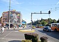
The beginning of Tsarigradsko shose at Orlov most

Tsarigradsko shose near Orlov Most

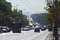
The eastern part of Tsarigradsko shose

Tsarigradsko shose near Mladost district

The ex-Printing factory

Office buildings

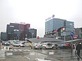
Vivacom Centre and The Mall
Looking at Orlov most

Capital Fort Building at the entrance to Sofia


| Wikimedia Commons has media related to Tzarigradsko shose. |
This Bulgarian road or road transport-related article is a stub. You can help Wikipedia by . |
- Streets in Sofia
- Bulgaria geography stubs
- Europe road stubs