Tuaran District
Tuaran District
Daerah Tuaran | |
|---|---|
District | |
 Tuaran District Office | |
 | |
| Coordinates: 6°11′00″N 116°14′00″E / 6.18333°N 116.23333°ECoordinates: 6°11′00″N 116°14′00″E / 6.18333°N 116.23333°E | |
| Country | |
| State | |
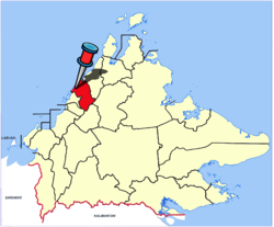
| Division | West Coast |
| Capital | Tuaran |
| Government | |
| • District Officer | Sadan Hussain |
| • MP | Wilfred Madius Tangau (UPKO) |
| • MLA |
|
| Area | |
| • Total | 1,165 km2 (450 sq mi) |
| Population (2010) | |
| • Total | 102,411 |
| Website | ww2 ww2 |

The Tuaran District (Malay: Daerah Tuaran) is an administrative district in the Malaysian state of Sabah, part of the West Coast Division which includes the districts of Kota Belud, Kota Kinabalu, Papar, Penampang, Putatan, Ranau and Tuaran. The capital of the district is in Tuaran Town.
Etymology[]
The origin of the name of "Tuaran" is somewhat uncertain as a settlement had existed since before the arrival of the British. One of the earliest recorded evidence of the use of Tuaran is through the letter of Stamford Raffles. After he became the governor of Java in 1813, he requested the British secretary in India to give him permission to enter the northern Borneo area after being invited by the Sultanate of Brunei.[1] The Sultan of Brunei request help from Raffles as the waters around Jawaran (Tuaran) and Jampasoo (Tempasuk) have been infected with piracy. The letter stated:
The present Sultan of Borneo Proper (Brunei) is understood to be well disposed not given the encouragement of piratical enterprise, notwithstanding the shelter is accorded to pirates in almost every river in his domain, a number of petty states having arisen beyond the reach of his authority and control. The most prominent of these states are the states of Jawaran (Tuaran) and Jampasoo (Tempasuk) to the northward of Borneo Proper……… It has been reported that Jawaran send about 50 prows (perahu) belonging to this states is estimated about 150 with from one to two hundred guns. The large prows armed with 10 feet long probably 12 and 18 paunders. Their crews consisting 80-200 men. The lanoons are the most considerable, formidable of these eastern pirates. There is little doubts that we the (East India Company) should be justified in the immediate destruction of these prows.[1]
Administrative District[]
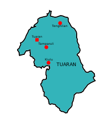

Tuaran District including;
| Tuaran District | |||||
|---|---|---|---|---|---|
| Area | Mukim | ||||
| Sulaman | Mukim Berungis
Mukim Tambalang Mukim Serusop Mukim Indai Mukim Mengkabong | ||||
| Kiulu | Mukim Ulu
Mukim Tengah Mukim Lembah Mukim Pantai Mukim Nabalu Mukim Pekan | ||||
| Tamparuli | Mukim Tamparuli
Mukim Tenghilan Mukim Topokon Mukim Tuaran Bandar Mukim Gayaratau/Rungus | ||||
Demographics[]
According to the last census in 2010, the population of the district is estimated to be around 102,411,[2] mainly Dusun and Bajau people as well a significant number of Chinese and Malay. As in other districts of Sabah, there are a significant number of illegal immigrants from the nearby southern Philippines, mainly from the Sulu Archipelago and Mindanao, many of whom are not included in the population statistics.
Tourism[]
Tourist attractions in Tuaran include the Mengkabong and Penimbawan water villages, which are villages of stilt houses built over the seashore by the Bajau people, and the Ling San Pagoda (Traditional Chinese: 龍山塔), a nine-storey Buddhist pagoda situated just outside the town centre. The main tourist resorts in Tuaran are the Mimpian Jadi Resort and Shangri-La's Rasa Ria Resort. In addition to food and lodging, these resorts offer various other activities such as golfing and water sports.
Gallery[]

An-Nur Mosque.

St. Andrew Anglican Church.
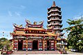
Ling San Pagoda.

Tuaran canopy walk.
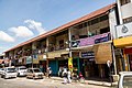
Tuaran shoplots.


See also[]
- Districts of Malaysia
References[]
- ^ a b "Sejarah / Asal Usul Daerah Tuaran" (in Malay). Tuaran District Council. Archived from the original on 10 November 2017. Retrieved 10 November 2017.
- ^ "Population by ethnic group, Local Authority area and state, Malaysia" (PDF). Department of Statistics, Malaysia. 2010. Archived from the original (PDF) on 27 February 2012. Retrieved 5 November 2017.
Further reading[]
- Treacher, W. H (1891). "British Borneo: sketches of Brunai, Sarawak, Labuan, and North Borneo". University of California Libraries. Singapore, Govt. print. dept. p. 190.
- Rutter, Owen (1922). "British North Borneo - An Account of its History, Resources and Native Tribes". Cornell University Libraries. Constable & Company Ltd, London. p. 157.
- Tregonning, K. G. (1965). A History Of Modern Sabah (North Borneo 1881–1963). University of Malaya Press.
External links[]
![]() Media related to Tuaran District at Wikimedia Commons
Media related to Tuaran District at Wikimedia Commons
- (in Malay) Tuaran District Council
- (in Malay) Tuaran District Office
State of Sabah | |||||||||||||
|---|---|---|---|---|---|---|---|---|---|---|---|---|---|
Capital: Kota Kinabalu | |||||||||||||
| |||||||||||||
| Society |
| ||||||||||||
| Administrative divisions |
| ||||||||||||
| |||||||||||||
This Sabah location article is a stub. You can help Wikipedia by . |
- Districts of Sabah
- Sabah geography stubs