Tucupit Point
| Tucupit Point | |
|---|---|
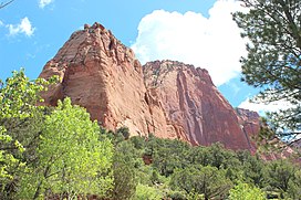 Tucupit Point from , May 2015 | |
| Highest point | |
| Elevation | 7,698 ft (2,346 m) NAVD 88 |
| Prominence | 138 ft |
| Coordinates | 37°27′46.8″N 113°10′25.8″W / 37.463000°N 113.173833°WCoordinates: 37°27′46.8″N 113°10′25.8″W / 37.463000°N 113.173833°W |
| Naming | |
| Native name | Wildcat Point Error {{native name checker}}: parameter value is malformed (help) |
| Geography | |
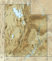 Tucupit Point Location of "Tucupit Point" in Zion National Park, Utah | |
| Location | Washington County, Utah, U.S. |

Tucupit Point is a prominent sandstone pinnacle in the Kolob Canyons area of Zion National Park in Washington County, Utah, United States.
Description[]
The formation lays off of ,[1] and rises with a prominence of 138 feet.[2] The pinnacle - visible from U.S. Route 40[clarification needed] to the west - has been the subject of numerous photographs. American artist Thomas Moran viewed the pinnacle in 1873 while travelling south from Salt Lake City, with the artist later rendering a famous watercolor of the feature.[3] The pinnacle was then named "Colburn's Butte" after Justin Colburn, a correspondent for the New York Times travelling with Moran; it would later be renamed Tucupit Point, "Tucupit" being the Paiute word for wildcat.[4]
See also[]
- List of mountains in Utah
- Paria Point
- Beatty Point
References[]
- ^ "North Fork of Taylor Creek Hiking Guide (Joe's Guide to Zion National Park)". www.citrusmilo.com. Retrieved 2020-01-28.
- ^ "Tucupit Point". peakery.com. Retrieved 2020-01-28.
- ^ "Colburn's Butte, South Utah". www.metmuseum.org. Retrieved 2020-01-28.
{{cite web}}: CS1 maint: url-status (link) - ^ Kaiser (2019-07-20). Zion: The Complete Guide: Zion National Park. James Kaiser. ISBN 978-1-940754-38-3.
External links[]
![]() Media related to Tucupit Point at Wikimedia Commons
Media related to Tucupit Point at Wikimedia Commons
This article about a location in Utah is a stub. You can help Wikipedia by . |
- Landforms of Washington County, Utah
- Landmarks in Utah
- Rock formations of Utah
- Zion National Park
- Utah geography stubs