Tutira
Tutira | |
|---|---|
Settlement | |
 | |
| Coordinates: 39°12′14″S 176°52′55″E / 39.204°S 176.882°ECoordinates: 39°12′14″S 176°52′55″E / 39.204°S 176.882°E | |
| Country | New Zealand |
| Region | Hawke's Bay Region |
| Territorial authority | Hastings District |
| Ward | Mohaka |
| Postcode(s) | 4181 |

Tutira (Māori: Tūtira) is a village to the north of Napier and is part of the Hawke's Bay Region in New Zealand's North Island. It is located on State Highway 2 between Wairoa and Napier.[2]
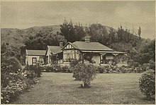
Much of the area was surveyed by Herbert Guthrie-Smith, who farmed 60,000 acres (240 km²) surrounding Lake Tūtira.[3] Guthrie-Smith, a naturalist, published the popular Tutira: the story of a New Zealand sheep station in 1921.[4] Today, a camp is run at the site of his homestead.[5]
Demographics[]
| Year | Pop. | ±% p.a. |
|---|---|---|
| 2006 | 1,743 | — |
| 2013 | 1,752 | +0.07% |
| 2018 | 1,839 | +0.97% |
| Source: [1] | ||
The statistical area of Puketitiri-Tutira, which at 2,433 square kilometres is much larger than this village and also includes Waipatiki Beach, Tangoio and Te Haroto, had a population of 1,839 at the 2018 New Zealand census, an increase of 87 people (5.0%) since the 2013 census, and an increase of 96 people (5.5%) since the 2006 census. There were 708 households. There were 969 males and 870 females, giving a sex ratio of 1.11 males per female. The median age was 40.2 years (compared with 37.4 years nationally), with 387 people (21.0%) aged under 15 years, 309 (16.8%) aged 15 to 29, 936 (50.9%) aged 30 to 64, and 201 (10.9%) aged 65 or older.
Ethnicities were 84.2% European/Pākehā, 22.3% Māori, 2.3% Pacific peoples, 1.6% Asian, and 2.4% other ethnicities (totals add to more than 100% since people could identify with multiple ethnicities).
The proportion of people born overseas was 9.8%, compared with 27.1% nationally.
Although some people objected to giving their religion, 57.7% had no religion, 30.8% were Christian, 0.2% were Muslim, 0.2% were Buddhist and 4.7% had other religions.
Of those at least 15 years old, 186 (12.8%) people had a bachelor or higher degree, and 261 (18.0%) people had no formal qualifications. The median income was $34,200, compared with $31,800 nationally. The employment status of those at least 15 was that 843 (58.1%) people were employed full-time, 261 (18.0%) were part-time, and 36 (2.5%) were unemployed.[1]
Education[]
Tutira School is a co-educational state primary school,[6][7] with a roll of 25 as of November 2021.[8][9]
References[]
- ^ a b c "Statistical area 1 dataset for 2018 Census". Statistics New Zealand. March 2020. Puketitiri-Tutira (208000). 2018 Census place summary: Puketitiri-Tutira
- ^ Hariss, Gavin. "Tutira, Hawke's Bay". topomap.co.nz. NZ Topo Map.
- ^ Cooper, Ronda. "Guthrie-Smith, William Herbert, Dictionary of New Zealand Biography, first published in 1996". teara.govt.nz. Te Ara - the Encyclopedia of New Zealand. Retrieved 21 February 2019.
- ^ Platts, Una. "Dobie, Beatrix (Mrs Vernon) 1887–c.1945". nzetc.victoria.ac.nz. Retrieved 4 September 2017.
- ^ McLintoc, A. H. (1966). "GUTHRIE-SMITH, William Herbert, from An Encyclopaedia of New Zealand, Te Ara - the Encyclopedia of New Zealand". www.teara.govt.nz. Retrieved 11 October 2017.
- ^ "Official School Website". tutira.school.nz.
- ^ "Ministry of Education School Profile". educationcounts.govt.nz. Ministry of Education.
- ^ "New Zealand Schools Directory". New Zealand Ministry of Education. Retrieved 22 December 2021.
- ^ "Education Review Office Report". ero.govt.nz. Education Review Office.
- Populated places in the Hawke's Bay Region
- Hastings District