Uacaba
Uacaba
Uacaba Jeeresaa Wakkaaba | |
|---|---|
Village | |
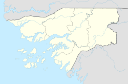 Uacaba Location in Guinea-Bissau | |
| Coordinates: 12°13′N 14°27′W / 12.217°N 14.450°WCoordinates: 12°13′N 14°27′W / 12.217°N 14.450°W | |
| Country | |
| Region | Gabú Region |
| Sector | Sonaco |
| Time zone | UTC+0 (GMT) |

Uacaba is a village in the Gabú Region of central-eastern Guinea-Bissau.
Location[]
It lies between to the west, and Canjia to the east.[1][2]
References[]
- ^ Google Maps (Map). Google.
{{cite map}}:|access-date=requires|url=(help) - ^ Bing Maps (Map). Microsoft and Harris Corporation Earthstar Geographics LLC.
{{cite map}}:|access-date=requires|url=(help)
External links[]
This Guinea-Bissau location article is a stub. You can help Wikipedia by . |
Categories:
- Populated places in Guinea-Bissau
- Gabu Region
- Guinea-Bissau geography stubs