Ubuyama, Kumamoto
Ubuyama
産山村 | |
|---|---|
Village | |
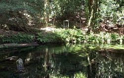 Ikeyama fountainhead | |
 Flag  Chapter | |
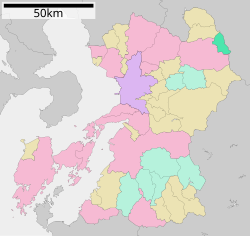 Location of Ubuyama in Kumamoto Prefecture | |
 Ubuyama Location in Japan | |
| Coordinates: 33°0′N 131°12′E / 33.000°N 131.200°ECoordinates: 33°0′N 131°12′E / 33.000°N 131.200°E | |
| Country | Japan |
| Region | Kyushu |
| Prefecture | Kumamoto Prefecture |
| District | Aso |
| Area | |
| • Total | 60.72 km2 (23.44 sq mi) |
| Population (March 31, 2017) | |
| • Total | 1,542 |
| • Density | 25/km2 (66/sq mi) |
| Time zone | UTC+09:00 (JST) |
| Website | www |

Ubuyama (産山村, Ubuyama-mura) is a village located in Aso District, Kumamoto Prefecture, Japan. It is located on the northeast rim of the Aso caldera.
As of January 2021, the village has an estimated population of 1,438[1] and a population density of 24 persons per km². The total area is 60.72 km².
Local attractions include Ubuyama Farm, Ikeyama fountainhead, Higotai Flower Park, Ubuyama Farm Village, hot springs, Ubuyama Campgrounds and several restaurants. Known for its clean water and delicious food, Ubuyama's economy is mainly based on agriculture and tourism. Most restaurants and tourist attractions close early.
Education[]
Ubuyama is home to an elementary school, junior high and a preschool. There is no high school. In 2009 the number of students attending junior high school was 55. Ubuyama employs one native English instructor (Assistant Language Teacher) through the JET Program to aid in teaching English.
References[]
- ^ "Official website of Ubuyama Village" (in Japanese). Japan: Ubuyama Village. Retrieved 2021-01-28.
External links[]
 Media related to Ubuyama, Kumamoto at Wikimedia Commons
- Ubuyama official website (in Japanese)
This Kumamoto Prefecture location article is a stub. You can help Wikipedia by . |
- Villages in Kumamoto Prefecture
- Kumamoto Prefecture geography stubs