Udenhout
Udenhout | |
|---|---|
 Flag  Coat of arms | |
| Coordinates: 51°36′30″N 5°8′30″E / 51.60833°N 5.14167°E | |
| Country | Netherlands |
| Province | North Brabant |
| Municipality | Tilburg |
| Population (2005) | 8,766 |
| Major roads | |


Udenhout is a village and a former municipality in the Dutch province of North Brabant. It is located northeast of Tilburg, north of Berkel-Enschot and south of the National Parc Loonse en Drunense Duinen.
The municipality of Udenhout (including the village of Biezenmortel) was independent until 1997, when it became part of the municipality of Tilburg. Biezenmortel became part of the municipality of Haaren. Udenhout preferred to join the municipality of Loon op Zand, but was nevertheless assigned to Tilburg. The municipality consisted at the time of abolition in 1996 9,028 inhabitants and was 26.87 km².
During Carnaval Udenhout is called: "d'n Haozepot".
Gallery[]
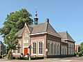
Udenhout, former town hall
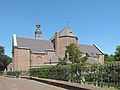
Udenhout, Saint Lambert's Church (Sint Lambertuskerk)


External links[]
J. Kuyper, Gemeente Atlas van Nederland, 1865-1870, "Udenhout". Map of the former municipality, around 1868.
Coordinates: 51°37′N 5°09′E / 51.617°N 5.150°E
This North Brabant location article is a stub. You can help Wikipedia by . |
- Municipalities of the Netherlands disestablished in 1997
- Populated places in North Brabant
- Former municipalities of North Brabant
- Tilburg
- North Brabant geography stubs