Undivided Assam
This article needs additional citations for verification. (July 2013) |
| State of Assam | |||||||||||
|---|---|---|---|---|---|---|---|---|---|---|---|
| State of India | |||||||||||
| 1947-1963 | |||||||||||
 Flag
 Coat of arms
| |||||||||||
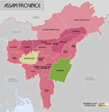 Assam in 1936 before division | |||||||||||
| Capital | Shillong | ||||||||||
| Area | |||||||||||
• | 121,908[2][3] km2 (47,069 sq mi) | ||||||||||
• | 202,270[1] km2 (78,100 sq mi) | ||||||||||
| History | |||||||||||
• Established | 1947 | ||||||||||
• Disestablished | 1963 | ||||||||||
| |||||||||||
Undivided Assam refers to the then undivided greater state of Assam in India soon after the Indian Independence in 1947 until 1963. In addition to the present-day Assam, it included the current states of Arunachal Pradesh, Meghalaya, Nagaland and Mizoram. The capital of this state was Shillong, currently the capital of Meghalaya. [4]
Prior to the Partition of India, Sylhet was a part of Assam.
Undivided Assam had a total area of 234,568 km2 (90,567 sq mi) which is slightly smaller than the nation of Ghana. The present day population of Undivided Assam will be 50 million which is slightly less than the population of South Korea.
Present day[]
After the partition, Undivided Assam was carved into following states:
| Date | State/UT | Country | Note |
|---|---|---|---|
| 15 Aug 1947 | Assam | Became states of Republic of India | |
| 1 Dec 1963 | Nagaland | ||
| 2 Apr 1970 | Meghalaya | ||
| 21 Jan 1972 | Mizoram | ||
| 21 Jan 1972 | Arunachal Pradesh |
References[]
- ^ Province area after Simla Convention and accession of South Tibet excluding dependent states.
- ^ Province area. Total area including dependent states (Manipur - 8456 sq mi and Khasi Hills - 6157 sq mi) is 61,682 sq mi (159755 км2)
- ^ The Imperial Gazetteer of India 1908, p. 14.
- ^ "Assam Gazzeter: Geology". Government of Assam. p. 33.
Categories:
- States and territories established in 1947
- States and territories disestablished in 1963
- Assam geography stubs
- 1947 establishments in India
- 1963 disestablishments in India
- 1940s in Assam
- 1950s in Assam
- 1960s in Assam
- Northeast India