Unorganized Yukon
Unorganized Yukon | |
|---|---|
Unorganized area | |
 | |
| Coordinates: 63°38′N 135°46′W / 63.633°N 135.767°WCoordinates: 63°38′N 135°46′W / 63.633°N 135.767°W | |
| Country | Canada |
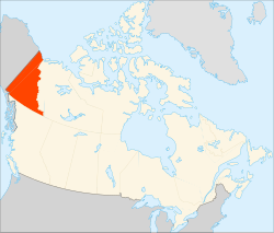
| Territory | Yukon |
| Area | |
| • Total | 465,513.32 km2 (179,735.70 sq mi) |
| Population (2011)[2] | |
| • Total | 1,495 |
| • Density | 0.0/km2 (0/sq mi) |
| • Change 2006-11 | |
| Time zone | UTC−07:00 (MST) |

Unorganized Yukon, or Yukon, Unorganized, is the unorganized area covering the majority of Yukon, Canada.[3] It represents 98% of Yukon's 474,712.64 km2 (183,287.57 sq mi) land mass, and is recognized as a census subdivision by Statistics Canada.[1]
Demographics[]
In the 2011 Census, Statistics Canada originally reported that Unorganized Yukon had a population of 1,688 living in 748 of its 1,088 total dwellings, a 31.3% change from its 2006 population of 1,286.[1] Statistics Canada subsequently amended the 2011 census results to a population of 1,495 living in 675 of its 1,012 total dwellings, a 16.3% change from 2006.[2] With a land area of 465,513.32 km2 (179,735.70 sq mi), it had a population density of 0.0032115/km2 (0.0083178/sq mi) in 2011.[1][2]
See also[]
- List of communities in Yukon
- Unorganized Borough, Alaska, a similar area in the neighbouring US state of Alaska
References[]
- ^ a b c d "Population and dwelling counts, for Canada, provinces and territories, and census subdivisions (municipalities), 2011 and 2006 censuses (Yukon)". Statistics Canada. 2012-02-08. Retrieved 2012-11-12.
- ^ a b c "Corrections and updates". Statistics Canada. 2012-10-24. Retrieved 2012-11-12.
- ^ "Census Profile - Map: Yukon, Unorganized". Statistics Canada. 2012-09-19. Retrieved 2012-11-12.
Places adjacent to Unorganized Yukon | |
|---|---|
| Municipalities | |
|---|---|
| Unorganized areas | |
| Communities (unincorporated) | |
| Ghost towns | |
| Parks | |
| Regions | |
| |
This article about a Yukon location is a stub. You can help Wikipedia by . |
- Geography of Yukon
- Yukon geography stubs