Unterbrunn
Unterbrunn | |
|---|---|
Ortsteil of Gauting | |
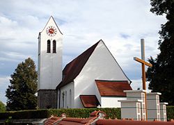 Church of Saint Lawrence | |
show Location of Unterbrunn | |
 Unterbrunn | |
| Coordinates: 48°03′59.28″N 11°19′25.69″E / 48.0664667°N 11.3238028°ECoordinates: 48°03′59.28″N 11°19′25.69″E / 48.0664667°N 11.3238028°E | |
| Country | Germany |
| State | Bavaria |
| District | Starnberg |
| Town | Gauting |
| Time zone | UTC+01:00 (CET) |
| • Summer (DST) | UTC+02:00 (CEST) |
| Website | http://www.unterbrunn.de |


The village of Unterbrunn is an Ortsteil (quarter) of the municipality Gauting, in Bavaria, Germany. It lies close to and east of the Oberpfaffenhofen Airfield (with IATA code: OBF).
Unterbrunn has an interesting RC parish church with organ pipes housed above the ceiling. It also boasts a private museum, basically eclectic but with many interesting historic farm implements.
History[]
This section is empty. You can help by . (July 2010) |
References[]
External links[]
| Authority control |
|
|---|
This Starnberg district location article is a stub. You can help Wikipedia by . |
Categories:
- Villages in Bavaria
- Upper Bavaria geography stubs