Upa (river)
| Upa | |
|---|---|
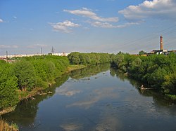 Upa river in Tula | |
| Native name | Упа (Russian) |
| Location | |
| Country | Russia |
| Physical characteristics | |
| Mouth | Oka |
• coordinates | 54°02′07″N 36°20′03″E / 54.03528°N 36.33417°ECoordinates: 54°02′07″N 36°20′03″E / 54.03528°N 36.33417°E |
| Length | 345 km (214 mi) |
| Basin size | 9,510 km2 (3,670 sq mi) |
| Basin features | |
| Progression | Oka→ Volga→ Caspian Sea |
| Tributaries | |
| • right | Plava |

The Upa (Russian: Упа́, Russian pronunciation: [ʊˈpa]) is a river in Tula Oblast, Russia, and one of the main tributaries of the Oka.
The river is 345 kilometres (214 mi) long, and has a drainage basin of 9,510 square kilometres (3,670 sq mi).[1] The city of Tula is situated on its banks. The name of the river is of Baltic origin.[2]
References[]
- ^ «Река УПА», Russian State Water Registry
- ^ E.M. Pospelov, Geograficheskie nazvaniya mira (Moscow: Russkie slovari, 1998), p. 423: "cf. Lithuanian ùpė, upìs, upỹs, Latvian upe 'river, stream.'"
This Tula Oblast location article is a stub. You can help Wikipedia by . |
This article related to a river in Russia is a stub. You can help Wikipedia by . |
Categories:
- Tributaries of the Oka
- Rivers of Tula Oblast
- Central Russia geography stubs
- Russia river stubs