Upton, Cambridgeshire


Upton is a village and civil parish in Peterborough, Cambridgeshire, England.[1] For electoral purposes it forms part of Glinton and Wittering ward in North West Cambridgeshire constituency.[2] The population of the parish is included in the civil parish of Sutton.
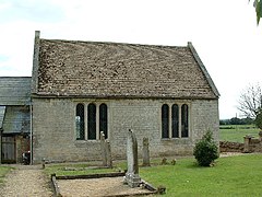
The Parish Church of St John the Baptist is a 12th-century Norman church with a north aisle rebuilt in 17th century. It was a chapel-of-ease and was built as a daughter church to St Kyneburgha's at Castor. The church is a Grade I listed building.[3] It is set in the fields to the east of the village, 100 yards from the Roman King Street.
References[]
- ^ Ordnance Survey: Landranger map sheet 142 Peterborough (Market Deeping & Chatteris) (Map). Ordnance Survey. 2012. ISBN 9780319229248.
- ^ "Ordnance Survey Election Maps". www.ordnancesurvey.co.uk. Ordnance Survey. Retrieved 3 April 2016.
- ^ Historic England. "Details from listed building database (1127440)". National Heritage List for England. Retrieved 20 April 2016.
External links[]
![]() Media related to Upton, Peterborough at Wikimedia Commons
Media related to Upton, Peterborough at Wikimedia Commons
This Cambridgeshire location article is a stub. You can help Wikipedia by . |
Categories:
- Villages in Cambridgeshire
- Geography of Peterborough
- Civil parishes in Cambridgeshire
- Cambridgeshire geography stubs