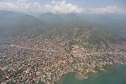
Uvira
Uvira | |
|---|---|
 | |
 Uvira | |
| Coordinates: 3°22′12″S 29°08′24″E / 3.37000°S 29.14000°E | |
| Country | |
| Province | South Kivu Province |
| Area | |
| • Urban | 74 km2 (29 sq mi) |
| Elevation | 746 m (2,448 ft) |
| Population (2020 estimate)[1] | |
| • Urban | 590,000 |
| • Urban density | 8,000/km2 (21,000/sq mi) |

Uvira is a city in the South Kivu Province of the Democratic Republic of Congo. Uvira is a Roman Catholic diocese, a suffragan of the archdiocese of Bukavu.
Geography[]
It is located at the extreme north end of Lake Tanganyika. Kalundu is a lake port at the southern end of the town, which provides links by boat to Kalemie in Katanga Province, Kigoma in Tanzania, Pulungu in Zambia and Bujumbura (the largest city and former capital of Burundi).
The town is linked by road to Bukavu (the capital of the South Kivu province), and Bujumbura. The town is 120 km from Bukavu and 60 km from the territory of Fizi.
Uvira is also linked by road to:
- Bujumbura, the former capital of Burundi (25 km)
- The territory of Fizi (60 km)
- Rwanda via Kamanyola border (80 km)
- Bukavu, the capital of the South Kivu province (120 km)
- Kalemie in Katanga Province (385 km)
Uvira Mental Health Center will serve primarily residents in territory of Uvira, territory of Fizi and Territory of Walungu (kamanyola), although individuals living outside the region may also receive care.
History[]
Uvira was the former capital of South Kivu Subregion, which was part of the Kivu region during the Mobutu era. Following the creation of South Kivu as a province, the capital transferred to Bukavu.
In 2017, the CNPSC rebel group launched an attack on the city, which was repelled by the national army and MONUSCO forces.
See also[]
Further reading[]
- Chubaka, Bishikwabo (1987). "Aux origines de la ville d'Uvira selon les exporateurs et les pionniers de la colonisation belge au Zaire (1840-1914)". Civilisations. 37 (1): 83–126. JSTOR 41968746.
External links[]
- "Retracing Che Guevara's Congo Footsteps". BBC News. 25 November 2004.
- Map "Uvira, Sud-Kivu, Congo-Kinshasa" (PDF). Reférential Geographique Commun, République Démocratique du Congo. 21 December 2012.[permanent dead link]
References[]
| Cities and communes |
| ||
|---|---|---|---|
| Territories | |||
| Populated places | |||
| Other | |||
Coordinates: 3°24′S 29°09′E / 3.400°S 29.150°E
This Democratic Republic of the Congo location article is a stub. You can help Wikipedia by . |
- Uvira
- Populated places in South Kivu
- Lake Tanganyika
- Democratic Republic of the Congo geography stubs