Vásárosnamény
This article needs additional citations for verification. (April 2014) |
Vásárosnamény | |
|---|---|
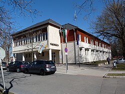 City hall of Vásárosnamény | |
 Flag  Coat of arms | |
 Vásárosnamény | |
| Coordinates: 48°7′36″N 22°19′6″E / 48.12667°N 22.31833°ECoordinates: 48°7′36″N 22°19′6″E / 48.12667°N 22.31833°E | |
| Country | |
| County | Szabolcs-Szatmár-Bereg |
| Area | |
| • Total | 65.66 km2 (25.35 sq mi) |
| Population (2001) | |
| • Total | 9,325 |
| • Density | 142/km2 (370/sq mi) |
| Time zone | UTC+1 (CET) |
| • Summer (DST) | UTC+2 (CEST) |
| Postal code | 4800, 4802–4804 |
| Area code(s) | 45 |


Location of Szabolcs-Szatmar-Bereg county in Hungary
Vásárosnamény is a small town in Szabolcs-Szatmár-Bereg county, in the Northern Great Plain region of eastern Hungary. It also includes Vitka since 1969, and in 1939 Gergelyi and Ugornya formed by uniting Gergelyiugornya.
It is located at around 48°7′35″N 22°19′5″E / 48.12639°N 22.31806°E.
Postal History[]
Prior to the breakup of Hungary at the end of World War I, the town was in Bereg county. The Post office was established in 1836. The postmaster began using a straight line postmark in 1839. In 1848, the post office began using the standard Hungarian double circle postmark.[1]


References[]
- ^ Handbook of the Pre-stamp Postmarks of Austria by Edwin Mueller, 1960
| show Authority control |
|---|
This Szabolcs-Szatmár-Bereg location article is a stub. You can help Wikipedia by . |
Categories:
- Populated places in Szabolcs-Szatmár-Bereg County
- Szabolcs-Szatmár-Bereg geography stubs