Vaila
| Old Norse name | Valey |
|---|---|
| Location | |
 Vaila Vaila shown within Scotland | |
| OS grid reference | HU213462 |
| Coordinates | 60°12′N 1°35′W / 60.20°N 1.58°W |
| Physical geography | |
| Island group | Shetland |
| Area | 327 hectares (1.26 sq mi) |
| Area rank | 82 [1] |
| Highest elevation | 95 metres (312 ft) |
| Administration | |
| Sovereign state | United Kingdom |
| Country | Scotland |
| Council area | Shetland Islands |
| Demographics | |
| Population | 2[2] |
| Population rank | 86= [1] |
| Population density | 0.6 people/km2[2][3] |
| References | [4][5] |

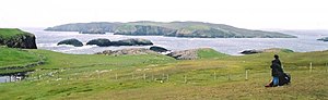
Vaila (Old Norse: "Valey") is an island in Shetland, Scotland, lying south of the Westland peninsula of the Shetland Mainland. It has an area of 327 hectares (810 acres), and is 95 metres (312 ft) at its highest point.[3]
Vaila is home to an organic sheep farm and is also known for its mountain hares.
History[]
The island has been inhabited for thousands of years, and Neolithic and Bronze Age remains have been found here.[3]
Older remains on the island include tower, which was restored in the 1890s.[6]
In 1490, the Ciske family's estates were divided and Vaila and Foula became the property of Alv Knutsson. However, the Ciskes were Norwegian, and as Scotland had annexed Shetland a few decades before, there were confusing and conflicting claims of ownership.[3]
In the 17th century Martin Martin recorded an unusual folk tale:
The inhabitants of the isle Vaila say that no cat will live in it, and if any cat be brought to it, they will rather venture to sea, than stay in the isle. They say that a cat was seen upon the isle about fifty years ago; but how it came there was unknown. They observed about the same time, how the proprietor was in great torment, and as they supposed by witchcraft, of which they say he then died. There is no account that any cat has been seen in the isle ever since that gentleman’s death except when they were carried to it, for making the above-mentioned experiment.[7]
In 1837, Arthur Anderson (the co-founder of P&O), chose the island as the base for his . This helped end landlords' dominance of the Shetland fishing industry.[8] The journalist John Sands lived on Vaila for a while during the late nineteenth century.[9]
, was built in the 1890s, by Herbert Anderton, a Yorkshire mill owner.[8] It is considered to be one of the finest mansions in all of Shetland. It incorporates an older laird's house, built by James Mitchell in 1696.[3][6] Stone and Labour were brought in from England, and ornamentation from even further away: for example, it is thought that the stone griffins may come from Germany.
The Andertons owned the island until 1993.[3]
Geography and geology[]
The geology consists of fine dark grey sandstone of the type found in nearby Walls, which was formed 400 million years ago, and subjected to glacial processes. There is some Sandsting granite in the south east by Gaada Stacks.[3]
There are five burns, and four ponds on the island, meaning that it is fairly well watered.
The south end is higher and dominated by Ward Hill (a common name in the Northern Isles.), which is divided into West Ward (81 metres (266 feet)), Mid Ward and East Ward (95 metres (312 feet)).[3]
There are several caves in the south and west, and natural arches on the east and west coasts.
To the north west is Wester Sound, and Easter Sound to the East. Vaila Sound is to the north, and contains one of the many Shetland islands called Linga.
See also[]
References[]
- ^ a b Area and population ranks: there are c. 300 islands over 20 ha in extent and 93 permanently inhabited islands were listed in the 2011 census.
- ^ a b National Records of Scotland (15 August 2013). "Appendix 2: Population and households on Scotland's Inhabited Islands" (PDF). Statistical Bulletin: 2011 Census: First Results on Population and Household Estimates for Scotland Release 1C (Part Two) (PDF) (Report). SG/2013/126. Retrieved 14 August 2020.
- ^ a b c d e f g h Haswell-Smith, Hamish. (2004) The Scottish Islands. Edinburgh. Canongate.
- ^ Ordnance Survey. OS Maps Online (Map). 1:25,000. Leisure.
- ^ Anderson, Joseph (Ed.) (1893) Orkneyinga Saga. Translated by Jón A. Hjaltalin & Gilbert Goudie. Edinburgh. James Thin and Mercat Press (1990 reprint). ISBN 0-901824-25-9
- ^ a b "Overview of Vaila". Archived from the original on 2019-04-22. Retrieved 2021-10-27.
- ^ Martin, Martin (1703) "A Description of The Western Islands of Scotland Archived March 13, 2007, at the Wayback Machine Appin Historical Society. Retrieved 3 March 2007.
- ^ a b Keay, J. & Keay, J. (1994) Collins Encyclopaedia of Scotland. London. HarperCollins.
- ^ Fleming, Andrew (2005) St Kilda and the Wider World: Tales of an iconic island. Macclesfield. Windgather Press. Page 159.
Shetland | ||
|---|---|---|
| Inhabited islands |
| |
| Other islands | ||
| Towns and villages | ||
| Mainland Parishes | ||
| Insular Parishes | ||
| Maritime features | ||
Extreme points
|
| |
| Topics |
| |
|  | ||||||||||||||||
|
| |||||||||||||||||
| |||||||||||||||||
| |||||||||||||||||
| |||||||||||||||||
| |||||||||||||||||
| |||||||||||||||||
| |||||||||||||||||
- Islands of Shetland
- Natural arches of Scotland
- Underwater diving sites in Scotland