Vaillac
Vaillac | |
|---|---|
Part of Cœur-de-Causse | |
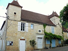 The town hall in Vaillac | |
show Location of Vaillac | |
 Vaillac | |
| Coordinates: 44°40′32″N 1°31′50″E / 44.6756°N 1.5306°ECoordinates: 44°40′32″N 1°31′50″E / 44.6756°N 1.5306°E | |
| Country | France |
| Region | Occitanie |
| Department | Lot |
| Arrondissement | Gourdon |
| Canton | Causse et Bouriane |
| Commune | Cœur-de-Causse |
| Area 1 | 13.68 km2 (5.28 sq mi) |
| Population (2017)[1] | 102 |
| • Density | 7.5/km2 (19/sq mi) |
| Time zone | UTC+01:00 (CET) |
| • Summer (DST) | UTC+02:00 (CEST) |
| Postal code | 46240 |
| Elevation | 239–422 m (784–1,385 ft) (avg. 275 m or 902 ft) |
| 1 French Land Register data, which excludes lakes, ponds, glaciers > 1 km2 (0.386 sq mi or 247 acres) and river estuaries. | |


Vaillac (French pronunciation: [vajak]; Languedocien: Valhac) is a former commune in the Lot department in south-western France. On 1 January 2016, it was merged into the new commune of Cœur-de-Causse.[2]
Geography[]
The village lies in the middle of the commune, in the valley of the Foulon, a stream tributary of the Céou, which flows westward through the northern part of the commune. There is a castle on the hill overlooking the village that is occasionally open to the public.
Sights and monuments[]
- The Château de Vaillac is a castle containing elements from the 14th, 15th, 16th and 17th centuries.[3]
- Église Saint-Julien, 14th - 15th century church
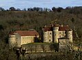
Château de Vaillac.

Vie of the church and the village.

Foulon brook.


See also[]
- Communes of the Lot department
References[]
- ^ Téléchargement du fichier d'ensemble des populations légales en 2017, INSEE
- ^ Arrêté préfectoral 30 October 2015
- ^ Base Mérimée: Château, Ministère français de la Culture. (in French)
| Wikimedia Commons has media related to Vaillac. |
This Lot geographical article is a stub. You can help Wikipedia by . |
Categories:
- Former communes of Lot (department)
- Lot (department) geography stubs