Valdivia River
| Valdivia River (Río Valdivia) | |
|---|---|
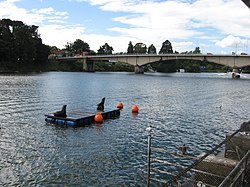
 View of the upper course of Valdivia River. Pedro de Valdivia Bridge is seen in the background. | |
| Location | |
| Country | Chile |
| Physical characteristics | |
| Source | |
| • location | Calle-Calle River, Caucau River |
| Mouth | |
• location | Corral Bay, Pacific Ocean |
• elevation | 0 m (0 ft) |
| Length | 15 km (9.3 mi)[1] |
| Basin size | 10,275 km2 (3,967 sq mi)[1] |
| Basin features | |
| Basin population | 168,489[1] |
The Valdivia River or Río Valdivia, as it is known locally, is a major river in southern Chile. It is the continuation of the Calle-Calle River, from the point where it meets the Cau-Cau River in the city of Valdivia. The Valdivia river ends in Corral Bay, on the Pacific coast. Other tributaries are the Cruces River, the Tornagaleones River and the Futa River. Pedro de Valdivia Bridge crosses the river in downtown Valdivia.
References[]
- ^ Jump up to: a b c "Cuenca del río Valdivia" (PDF). Archived from the original (PDF) on 2007-09-27. Retrieved 2007-10-28.
External links[]
Coordinates: 39°52′44″S 73°23′05″W / 39.878852°S 73.384824°W
Categories:
- Rivers of Chile
- Rivers of Los Ríos Region
- Rowing venues
- Los Ríos Region geography stubs
- Chile river stubs
