Valkkoog
hideThis article has multiple issues. Please help or discuss these issues on the talk page. (Learn how and when to remove these template messages)
|
Valkkoog | |
|---|---|
Village | |
 | |
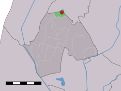 The village (dark red) and the statistical district (light green) of Valkkoog in the former municipality of Harenkarspel. | |
| Coordinates: 52°47′N 4°46′E / 52.783°N 4.767°ECoordinates: 52°47′N 4°46′E / 52.783°N 4.767°E | |
| Country | Netherlands |
| Province | North Holland |
| Municipality | Schagen |
| Population | |
| • Total | 160 |
| Time zone | UTC+1 (CET) |
| • Summer (DST) | UTC+2 (CEST) |


Valkkoog, reformed church
Valkkoog (West Frisian: Falkekoeghe) is a village in the Dutch province of North Holland. It is a part of the municipality of Schagen, and lies about 12 km north of Heerhugowaard.
The statistical area "Valkkoog", which also can include the surrounding countryside, has a population of around 130.[1]
References[]
- ^ Statistics Netherlands (CBS), Statline: Kerncijfers wijken en buurten 2003-2005. As of 1 January 2005.
| Authority control |
|
|---|
This North Holland location article is a stub. You can help Wikipedia by . |
Categories:
- Places of local interest needing cleanup
- Schagen
- Populated places in North Holland
- North Holland geography stubs