Valle Department
Valle Department
Departamento de Valle | |
|---|---|
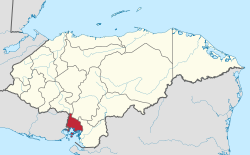 Location of Valle in Honduras | |
| Coordinates: 13°32′N 87°29′W / 13.533°N 87.483°WCoordinates: 13°32′N 87°29′W / 13.533°N 87.483°W | |
| Country | |
| Municipalities | 9 |
| Villages | 86 |
| Founded | 11 July 1893 |
| Capital city | Nacaome |
| Government | |
| • Type | Departmental |
| • Gobernador | Lenín Cruz Padilla (2018-2022) (PNH) |
| Area | |
| • Total | 1,618 km2 (625 sq mi) |
| Population (2015) | |
| • Total | 178,561 |
| • Density | 110/km2 (290/sq mi) |
| Time zone | UTC-6 (CDT) |
| Postal code | 52101 |
| ISO 3166 code | HN-VA |
| HDI (2017) | 0.586[1] medium · 8th |
| Statistics derived from Consult INE online database: Population and Housing Census 2013[2] | |

Valle is one of the 18 departments into which Honduras is divided.
The departmental capital is Nacaome. The department faces the Gulf of Fonseca and contains mangrove swamps; inland, it is very hot and dry.
The department covers a total surface area of 1,665 km² and, in 2015, had an estimated population of 178,561 people.
Valle Department was organized in 1893.
Municipalities[]
References[]
- ^ "Sub-national HDI - Area Database - Global Data Lab". hdi.globaldatalab.org. Retrieved 2018-09-13.
- ^ "Consulta Base de datos INE en línea: Censo de Población y Vivienda 2013" [Consult INE online database: Population and Housing Census 2013]. Instituto Nacional de Estadística (INE) (in Spanish). El Instituto Nacional de Estadística (INE). 1 August 2018. Retrieved 2018-09-13.
| hide | ||
|---|---|---|
| ||
| Authority control |
|
|---|
This Honduras location article is a stub. You can help Wikipedia by . |
Categories:
- Valle Department
- Departments of Honduras
- States and territories established in 1893
- Honduras geography stubs