Van Ness Avenue
This article needs additional citations for verification. (July 2018) |
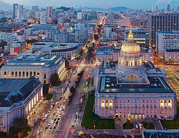 Van Ness Avenue and San Francisco City Hall at dusk | |||
| Former name(s) | Marlette Street | ||
|---|---|---|---|
| Part of |
| ||
| Namesake | James Van Ness | ||
| Maintained by | San Francisco DPW, Caltrans | ||
| Length | 4.2 mi[1] (6.8 km) | ||
| Nearest metro station |
| ||
| South end | Cesar Chavez (Army) Street | ||
| Major junctions |
| ||
| North end | Aquatic Park Pier | ||
Van Ness Avenue is a north–south thoroughfare in San Francisco, California. Originally named Marlette Street, the street was renamed Van Ness Avenue in honor of the city's seventh mayor, James Van Ness.[2][3][when?]
The main part of Van Ness Avenue runs from Market Street near the Civic Center north to Bay Street at Fort Mason. South Van Ness Avenue is the portion of Van Ness south of Market Street, continuing through the city's South of Market and Mission districts to end at Cesar Chavez Street. This southern segment was formerly a continuation of Howard Street, having been renamed by resolution of the Board of Supervisors on August 22, 1932.[4]
The route is designated US 101 from the Central Freeway at the convergence of South Van Ness, Howard Street, and 13th Street, north to Lombard Street.[5] Of the more striking landmarks along the route are the San Francisco City Hall, the War Memorial Opera House, and Louise M. Davies Symphony Hall.
History[]
Originally a quiet residential neighborhood of mansions, the street was used as a firebreak by the US Army during the 1906 earthquake and fire that destroyed most of San Francisco. Many of the buildings were dynamited along the street by soldiers in an ultimately successful attempt to prevent the firestorm from spreading west to the entire city.
After the earthquake, Van Ness served as the temporary commercial center and main thoroughfare of San Francisco, as it ultimately evolved into a busy commercial district in its own right, attracting many car dealerships that still exist, as most of the city's car and scooter dealerships line the street. It still remains a generally upscale area with large and grand apartment buildings, restaurants, and movie theaters.
Streetcar service started on Van Ness in 1915 for the opening of the Panama–Pacific International Exposition. The rail lines were removed in the 1950s and replaced with a tree-lined median.[6]
First recorded traffic accident (1865)[]
The first recorded traffic accident on Van Ness Avenue was reported in the San Francisco Examiner on November 6, 1865, as follows:
DREADFUL ACCIDENT: Wm. P. Slocomb, a young man about 18 years old, son of R.W. Slocomb, of the Tenth District, met with a terrible accident yesterday. He was riding home on horseback, and when about Bush Street and Van Ness Avenue, met a milk team running away. The team struck the horse young Slocomb was riding, and knocked down horse and rider. His foot caught in the stirrup, and animal ran away, dragging the boy for some distance, and finally breaking his skull.[7]
Today[]
The Academy of Art University owns and operates several buildings on the street for housing and academic purposes.[8] The $309m Van Ness Improvement Project broke ground in 2016, designed to make several improvements to Van Ness Avenue, including modernizing the 1800s-era water main, building an earthquake-resistant underground sewage system, and the construction of the Van Ness Bus Rapid Transit line.[9]
Major intersections[]
The entire route is within the borders of San Francisco.
| Destinations | Notes |
|---|---|
| Cesar Chavez Street | |
| South end of US 101 overlap; interchange | |
| Mission Street | |
| Market Street | |
| Geary Boulevard | |
| North end of US 101 overlap | |
| Bay Street | "Three Corners" |
See also[]
References[]
| Wikimedia Commons has media related to Van Ness Avenue (San Francisco). |
- ^ "Google Maps". Google Maps.
- ^ San Francisco Planning Department (2009). "Area Plan: Van Ness Avenue". City & County of San Francisco. Retrieved 2010-02-01.
- ^ "Early San Francisco Street Names: 1846-1849". San Francisco Museum. Retrieved 2010-02-01.
- ^ "LIFE IN THE MISSION by Frank R. Quinn - FoundSF". www.foundsf.org.
- ^ The location of Van Ness Avenue, Google Map
- ^ Rodriguez, Joe Fitzgerald (January 15, 2016). "Trees, historic trolley poles to be removed for bus project". The San Francisco Examiner. Retrieved 22 May 2016.
- ^ "6 Nov 1865, 3 - The San Francisco Examiner at Newspapers.com". Newspapers.com.
- ^ "Academy of Art University Campus Map" (PDF). academyart.edu. Academy of Art University. Retrieved 18 April 2017.
- ^ "Van Ness Improvement Project". sfmta.com. San Francisco Municipal Transportation Agency. Retrieved 30 December 2020.
Coordinates: 37°48′29″N 122°25′36″W / 37.80802°N 122.42659°W

| Numbered streets |  | |
|---|---|---|
| North–south streets |
| |
| East–west streets | ||
| Diagonal streets | ||
| Alleyways | ||
San Francisco place names etymologies | ||
- Streets in San Francisco
- U.S. Route 101