Vanguard Way
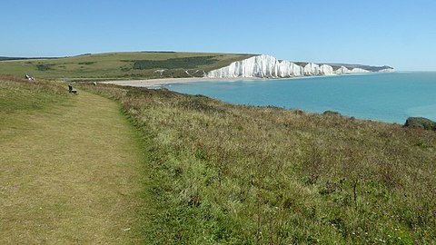
The Vanguard Way is a long-distance walk of 66.2 mi (106.5 km)[1] from East Croydon station in outer London (OS grid reference TQ328658), travelling from the north, to Newhaven, on the south coast of England.[2][3] It passes through the counties of Surrey, Kent and East Sussex, between Croydon and Newhaven, East Sussex.[2] It connects the London suburbs to the south coast, via the North Downs, Ashdown Forest, South Downs National Park and the Cuckmere valley.[2]
The walk was developed in celebration of the 15th anniversary in 1980 of the Vanguards Rambling Club, who named themselves after an occasion when they returned from a walk travelling in the guard's van of a crowded train.[4] The route's formal establishment occurred on 3 May 1981, and the Vanguards Rambling Club have remained as the route's management.[5][3]
The Vanguard Way connects with central London with the Wandle Trail along the River Wandle from Croydon and is sometimes used as a walking route between London and Paris, connecting with the ferry ports on the south coast. The walk also connects with the London Outer Orbital Path, North Downs Way, Greensand Way, London Countryway, Eden Valley Walk, Forest Way, Wealdway, Sussex Border Path and the South Downs Way.
Places on the way[]
- Croydon
- Woldingham
- Crockham Hill
- Forest Row
- Blackboys
- Berwick
- Alfriston
- Seaford
- Newhaven
Gallery[]
References[]
- ^ "Vanguard Way – LDWA Long Distance Paths". Long Distance Walkers Association. Retrieved 5 May 2019.
- ^ a b c "Vanguard Way (including map, GPS files and statistics)". WalkingEnglishman.com. Retrieved 5 May 2019.
- ^ a b "Vanguard Way – Walking Tour in Croydon – Visit South East England". Tourism South East. 2019. Retrieved 5 May 2019.
- ^ Saunders, Colin (2018). "Footline Press". ColinSaunders.org.uk. Retrieved 5 May 2019.
This remarkable and idiosyncratic walking route was set up in 1981 by the Vanguards Rambling Club, which takes its name from their being established in the guard’s van of a ramblers’ excursion train...
- ^ Saunders, Colin (2009). "The Vanguard Way – How It All Began – Action". Users.GreenBee.net. Retrieved 5 May 2019.
External links[]
| Wikimedia Commons has media related to Vanguard Way. |
- Official website
 – includes a free downloadable guide to the route
 - The Vanguard Way – detailed coverage by Long Distance Walkers Association
- Interactive map of the Vanguard Way – from The Walking Englishman
Coordinates: 50°59′00″N 0°08′55″E / 50.983302°N 0.148689°E
- Transport in the London Borough of Croydon
- Footpaths in Surrey
- Footpaths in East Sussex
- Long-distance footpaths in England
- Ashdown Forest
 WikiMiniAtlas


