Vassfaret
| Vassfaret | |
|---|---|
| Geography | |
| Location | Viken and Innlandet, Norway |
| Coordinates | 60°32′04″N 9°29′22″E / 60.5345°N 9.4895°ECoordinates: 60°32′04″N 9°29′22″E / 60.5345°N 9.4895°E |


Vassfaret is a forested mountain valley in southern Norway, bordering Flå, Nes, Ringerike and Sør-Aurdal municipalities and Innlandet and Viken counties. The valley is said to be between the Hallingdal and Hedalen in the traditional district of Valdres.[1]
History[]
Vassfaret is characterized by low alpine coniferous forests, heather and bog. Down in the valley there are a number of lakes in the forest. Up in the mountain it is rocky and weather beaten. The whole valley is not more than about 30 km long, with remnants from the timber floating era and old farms. There has been human activity in Vassfaret as early as the times before the Black Death in 1349. In later ages there were permanent settlements until 1921, when the last inhabitants left. In all there are remnants of 12 farms, as well as remnants of mountain farms. People have worked with logging and timber floating for more than 300 years in this valley. Numerous artifacts are left including dams, walls constructed by stones out in the rivers, and runs to get the logs past troublesome spots. [2]
During World War II, 1940–1945, and especially in the later years, there was intense activity in Vassfaret. This was the operational base a Resistance group code-named "ELG", and because of this there were many parachute drops there. There are still missing airdrops in the area.[3]
By royal decree on June 28, 1985, the Vassfaret and Vidalen landscapes were made a protected area. The intention is to take care of characteristic flora and fauna of eastern Norway, especially as an area for bears. as well as the cultural remains from logging and floating. A special area covering cultural protection covers about 8 km² within the Inner Vassfaret landscape protection area. Within this area there is logging by the old methods, and the logs are transported by horse. Every spring the logs are floated downstream into the Nevlingen River.[4][5]
Protected area[]
- Vassfaret and Vidalen conservation area (Vassfaret/Vidalen landskapsvernområde) covering 200 km²
- Inner Vassfaret conservation area (Indre Vassfaret landskapsvernområde), covering 42 km²
- 9 small nature reserves, a total of 18 km², with a very strict protection regime
Vassfarplassen[]
In the northern end of the Nevlingen River, there are the remains of a farm called Vassfarplassen, where the farmer owned a gun called Vassfarloven, which means "The Law of Vassfaret". In previous times, not all was very social of those living in Vassfaret. A special internal relationship existed, and anyone coming from neighbouring valleys could not expect a friendly welcome. Especially so when it comes to fishing. The saying was that in the middle of Nevlingen there was a shallow area; you could row to that point, but if you get any closer, then you were within range of The Law of Vassfaret. And the owner of that rifle was an excellent marksman.
Authors writing about Vassfaret[]
Gallery[]
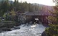
Nevlingdammen research facility on the Nevlingen River

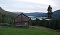
Reconstructed parts of Vassfarplassen
View from Vassfarplassen

Vidalen

Winterlandscape in Vassfaret


References[]
- ^ "Vassfaret". visitnorway.no. Retrieved December 1, 2017.
- ^ "Vassfaret". gonorway.com. Retrieved December 1, 2017.
- ^ Strande, Paul M.: Fallskjermer over vassfaret, Gyldendal. Oslo, 1977. (in Norwegian)
- ^ "Vassfaret". Norske Naturperler. Retrieved December 1, 2017.
- ^ "Vassfaret". Vassfaropplevelser. Retrieved December 1, 2017.
| Wikimedia Commons has media related to Vassfaret. |
Sources[]
- Elsrud, Edvard Berte Skrukkefyllhaugen: Boken om Vassfaret og de som bodde der (Grøndahl. 1979) ISBN 978-82-504-0358-1
- Elsrud, Edvard Bjørnejakt i Vassfaret (Landbruksforlaget. 1991) ISBN 82-529-1900-6
- Rønning, Bjarne Fra Silver Bar til Vassfaret ( Aschehoug. 1978) ISBN 978-82-03-09722-5
- Hohle, Per Vassfaret (Gyldendal. 1982) ISBN 978-82-05-14000-4
External links[]
- Valleys of Innlandet
- Valleys of Viken