Vasyugan
| Vasyugan | |
|---|---|
 | |
| Location | |
| Country | Russia |
| Physical characteristics | |
| Mouth | Ob |
• coordinates | 59°05′35″N 80°42′25″E / 59.0931°N 80.7069°ECoordinates: 59°05′35″N 80°42′25″E / 59.0931°N 80.7069°E |
| Length | 1,082 km (672 mi) |
| Basin size | 61,800 km2 (23,900 sq mi) |
| Basin features | |
| Progression | Ob→ Kara Sea |

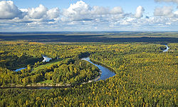
The Vasyugan (Russian: Васюга́н) is a river in the southern West Siberian Plain of Russia. It is a tributary of the Ob on the left side, and its course from its source in the Vasyugan Swamp is entirely within the Kargasok district of Tomsk Oblast.
Statistics[]
The river is 1,082 kilometres (672 mi) long[1] and is navigable upriver for 886 kilometres (551 mi) from the mouth. The Vasyugan drains a basin of 61,800 square kilometres (23,900 sq mi).[1] Average annual runoff: 345 m³ / c, 10.9 km³ / year.
Tributaries:
- Right hand: Yelizarovka, Petryak, Yershovka, Kalganak, Pyonorovka, Nyurolka, Zimnyaya, Chizhapka, Pasil, Silga, Naushka, Kochebilovka, Lozunga.
- Left hand: Bolshoy Petryak, Listvenka, Korovya, Staritsa, Garchak, Kyn, Glukhaya, Chertala, Yagylyakh, Yegolyakh, Olenyovka, Kelvat, Lontynyakh, Katylga, Cheremshanka, Prudovaya, Makhnya, Martynovka, Varingyogan, Yokhomyakh, Chebachya, Kacharma, Malaya Kuletka.
Municipalities (downstream from source): Novy Vasyugan, Aypolovo, Novy Tevriz, Sredny Vasyugan, Staraya Beryozovka, Ust-Chizhapka, Naunak, Bolshaya Griva, Staroyugino, Novoyugino, Bondarka.
Literature[]
- Evseeva NS Geography of Tomsk region. (Natural conditions and resources). - Tomsk: TSU, 2001, 223 pp.
References[]
- ^ Jump up to: a b Река ВАСЮГАН in the State Water Register of Russia (Russian)
| Authority control |
|---|
This Tomsk Oblast location article is a stub. You can help Wikipedia by . |
This article related to a river in Russia is a stub. You can help Wikipedia by . |
- Tributaries of the Ob
- Rivers of Tomsk Oblast
- Siberia geography stubs
- Russia river stubs