Vaupés River
| Vaupés River Uaupés River | |
|---|---|
 | |
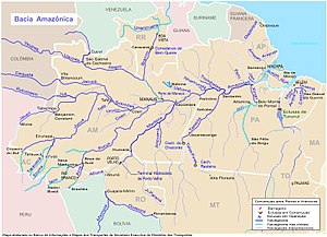 Vaupés (Uaupés) is in the upper left section | |
| Location | |
| Countries | |
| Physical characteristics | |
| Source | |
| • location | Guaviare Department, Colombia |
| • coordinates | 2°9′1″N 72°57′13″W / 2.15028°N 72.95361°W (approximately) |
| • elevation | 360 m (approximately) |
| Mouth | Rio Negro |
| Length | 1,050 km (650 mi)[1] |
| Discharge | |
| • average | 4,040 m3/s (143,000 cu ft/s) |

Vaupés River (Uaupés River) is a tributary of the Rio Negro in South America. It rises in the Guaviare Department of Colombia, flowing east through Guaviare and Vaupés Departments. It forms part of the international border between Colombia and the Amazonas state of Brazil. On the border it merges with the Papurí River and becomes known as the Uaupés. In 1847 an explorer saw a rapid which hurled its waves 12 or 15 metres (40 or 50 ft) in the air, "as if great subaqueous explosions were taking place."[2] The river continues on east through the Alto Rio Negro Indigenous Territory until it flows into the Rio Negro at São Joaquim, Amazonas.[3] Vaupés is a blackwater river.
See also[]
References[]
- ^ Ziesler, R.; Ardizzone, G.D. (1979). "Amazon River System". The Inland waters of Latin America. Food and Agriculture Organization of the United Nations. ISBN 92-5-000780-9. Archived from the original on 8 November 2014.
- ^ Discoveries and Explorations, Charles G.D. Roberts, 1905, p.224
- ^ "Terra Indígena Alto Rio Negro", Terras Indígenas no Brasil (in Portuguese), ISA: Instituto Socioambiental, retrieved 2017-03-04
External links[]
Coordinates: 0°02′03″N 67°16′50″W / 0.0341833°N 67.2806°W
| hide Authority control | |
|---|---|
| General |
|
| National libraries | |
Categories:
- Rivers of Amazonas (Brazilian state)
- Rivers of Colombia
- International rivers of South America
- Brazil–Colombia border
- Geography of Vaupés Department
- Geography of Guaviare Department
- Border rivers
- Tributaries of the Rio Negro (Amazon)
- Amazonas (Brazilian state) river stubs