Veerasolapuram
Veerasolapuram
Veeracholapuram | |
|---|---|
village | |
 National Highway-79 -sudhan | |
 Veerasolapuram | |
| Coordinates: 11°44′51″N 79°01′46″E / 11.747483°N 79.029357°ECoordinates: 11°44′51″N 79°01′46″E / 11.747483°N 79.029357°E | |
| Country | |
| State | Tamil Nadu |
| District | Kallakurichi |
| Taluka | Kallakkurichi |
| Population (2011) | |
| • Total | 1,929 |
| Time zone | UTC+5:30 (IST) |
| PIN | 606 206 |
| Telephone code | 04151 |
| Vehicle registration | TN-15 |


Veerasolapuram is an ancient village located near Kallakurichi in Kallakurichi district, Tamil Nadu, India.[1]
Climate[]
The temperature is moderate; the maximum and minimum temperatures being 38 °C and 21 °C respectively. The town gets its rainfall from the northeast monsoon in winter and the southwest monsoon in summer. The average annual rainfall is 1070 mm.
Agriculture[]
Veerasolapuram is an agricultural village. Major crops cultivated are sugarcane and rice. The river Manimuktha runs through the village providing enough water throughout the year for irrigation.
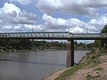
ManiMutha River

Historical Temples[]

Lord Siva Temple
Perumal Temple


References[]
| Wikimedia Commons has media related to Veerasolapuram. |
- ^ 2011 Census Village code for Veeracholapuram = 634599, "Reports of National Panchayat Directory: List of Census Villages mapped for: Veerasolapuram Gram Panchayat, Kallakurichi, Villupuram, Tamil Nadu". Registrar General & Census Commissioner, India.
- ^ http://tnmaps.tn.nic.in/district.php
- ^ http://www.viluppuram.tn.nic.in/ataglancepage.htm
Categories:
- Villages in Kallakurichi district