Velp, Gelderland
Velp | |
|---|---|
 360° Panorama, Main Street, Velp, The Netherlands. | |
| Coordinates: 51°59′41″N 5°58′33″E / 51.99472°N 5.97583°ECoordinates: 51°59′41″N 5°58′33″E / 51.99472°N 5.97583°E | |
| Country | Netherlands |
| Province | Gelderland |
| Municipality | Rheden |
| Population (2007) | circa 17,563 |
| Dialling code | 026 |
| Major roads | A12 |

Velp is a Dutch village located East to Arnhem within the municipality of Rheden, located between Arnhem, Rozendaal, and the town of Rheden. The population is 17,669 (2005). The town of Velp covers an area of approximately 11.01 square kilometres (4.25 sq mi).
Velp was a separate municipality between 1812 and 1818, when it was merged with Rheden. The municipality also covered the village Rozendaal.[1]
Gallery[]
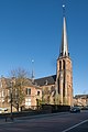
Church: Onze Lieve Vrouw Visitatiekerk

New Church, built 1841

Castle: het Biljoen
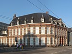
Monumental office building at the Hoofdstraat

View to a street (de Hoofdstraat)
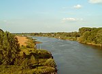
River IJssel near Velp

Veluwe near Velp, tree in the field at the Driesprong


Notable residents[]
- Jan Goossens, former American indoor soccer player.
- Ho-Pin Tung, Chinese-Dutch auto-racing driver
- René Klaassen, former field hockey defender
- Mina Kruseman, 19th-century feminist and author
- Ella van Heemstra, aristocrat and mother of Audrey Hepburn
- Audrey Hepburn, 20th-century actress and humanitarian
References[]
- ^ Ad van der Meer and Onno Boonstra, Repertorium van Nederlandse gemeenten, KNAW, 2011.
External links[]
| Wikimedia Commons has media related to Velp, Gelderland. |
- J. Kuyper, Gemeente Atlas van Nederland, 1865-1870, "Velp". Map of the former municipality, around 1868.
| hide Authority control | |
|---|---|
| General |
|
| National libraries | |
| Other |
|
This Gelderland location article is a stub. You can help Wikipedia by . |
Categories:
- Populated places in Gelderland
- Former municipalities of Gelderland
- Rheden
- Gelderland geography stubs