Vernon Circle
Coordinates: 35°16′55″S 149°07′44″E / 35.282°S 149.129°E

Vernon Circle | |
|---|---|
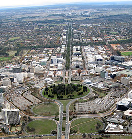 | |
| Aerial view looking north over Vernon Circle | |
 | |
 Vernon Circle | |
| Coordinates | |
| General information | |
| Type | Highway |
| Length | 750 m (0.5 mi) |
| Route number(s) | |
| Former route number |
|
| Major junctions | |
| South end | Civic, Australian Capital Territory |
| |
| North end | Civic, Australian Capital Territory |
| Location(s) | |
| Major suburbs | Civic |
| Highway system | |
Vernon Circle is a road in Canberra, Australia that encircles City Hill.
It was named after Walter Liberty Vernon.[1][2]
References[]
- ^ "Northbourne Avenue, Vernon Circle, Commonwealth Avenue, State Circle, Capital Circle, Canberra Avenue, Hume Place and Monaro Highway (National Route 23) - Acton to Fyshwick". Road Photos & Information: Australian Capital Territory. Paul Rands. Retrieved 21 September 2014.[self-published source]
- ^ "Vernon Circle". ACT Government, Environment and Planning. Retrieved 21 September 2014.
| Controlled-access roads: | ||
|---|---|---|
| Limited-access roads: |
| |
| Major interchanges: | ||
*Partially limited-access ^Partially controlled-access roadway under construction | ||
This Australian road or road transport-related article is a stub. You can help Wikipedia by . |
Categories:
- Streets in Canberra
- Australia road stubs