Vila Real
Vila Real | |
|---|---|
      | |
 Flag  Coat of arms | |
 | |
| Coordinates: 41°17′45″N 07°44′46″W / 41.29583°N 7.74611°WCoordinates: 41°17′45″N 07°44′46″W / 41.29583°N 7.74611°W | |
| Country | |
| Region | Norte |
| Intermunic. comm. | Douro |
| District | Vila Real |
| Established | City: 1925 |
| Government | |
| • President | Rui Santos (PS) |
| Area | |
| • Total | 378.80 km2 (146.26 sq mi) |
| Elevation | 450 m (1,480 ft) |
| Population (2011) | |
| • Total | 51,850 |
| • Density | 140/km2 (350/sq mi) |
| Time zone | UTC±00:00 (WET) |
| • Summer (DST) | UTC+01:00 (WEST) |
| Postal code | 5000 |
| Area code | 259 |

Vila Real (Portuguese pronunciation: [ˈvilɐ ʁiˈal] (![]() listen)) is the capital and largest city of the Vila Real District, northern Portugal. The population in 2011 was 51,850,[1] in an area of 378.80 square kilometres (146.26 sq mi).[2]
listen)) is the capital and largest city of the Vila Real District, northern Portugal. The population in 2011 was 51,850,[1] in an area of 378.80 square kilometres (146.26 sq mi).[2]
Vila Real was ranked seventh in the list of Portugal's most livable cities in the survey of living conditions published by the Portuguese newspaper Expresso in 2007.[3]
History[]
The region shows traces of inhabitation during the paleolithic era, while the settlement of Panóias had a Roman presence. Vila Real itself was founded in 1289 by King Denis of Portugal, hence its name, meaning Royal Town. It housed more members of the royal family during the Middle Ages than any other settlement in Portugal except the capital in Lisbon, and family Coats of Arms remain above old houses, some of which still occupied by those families. Vineyards were introduced to the municipality in 1764, growing red, white and rosé wines for export. Despite its royal presence, Vila Real only gained city status under the Portuguese Republic in 1925.[4]
Coat of arms[]
The coat of arms of Vila Real - a sword embedded in a wreath of zambujeiro (wild olive tree) and the slogan Aleu - is derived from the decorative motif of the tomb of Pedro de Menezes, 1st Count of Vila Real, found in the Igreja da Graça in Santarém. 'Aleu' or 'aleo' is an old Portuguese term for a 'gaming stick' (as used in hockey or shuffleboard). It refers to a famous episode concerning Pedro de Menezes from shortly after the Conquest of Ceuta on September 2, 1415 (commemorated on Ceuta Day). Pedro de Menezes was engaged in an outdoor game in the king's presence when a messenger arrived reporting an imminent Moroccan attack on Portuguese-held Ceuta. Menezes is said to have raised his gaming stick (aleo) and told the king that "with that stick alone" he could defend Ceuta from all the power of Morocco.[5] Similar design can be seen on the coat of arms of Alcoutim, where Pedro's descendants were made Count's of Alcoutim.
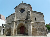
Main sights[]

- Capela da Misericórdia
- Capela de São Brás e o túmulo de Teixeira de Macedo
- Capela do Espírito Santo ou Capela do Bom Jesus do Hospital
- Diogo Cão's house
- Carvalho Araújo's house
- Brocas' house
- Marqueses's house de Vila Real
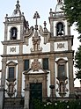
- Cathedral of Vila Real
- St. Peter's church
- Bom Jesus do Calvário church
- Clérigos's church or "Capela Nova"
- Pelourinho de Vila Real
Museums[]
- Archaeology and Numismatic Museum
- Geology Museum at the Universidade de Trás-os-Montes e Alto Douro
- Ethnographic Museum
- Sound and Image Museum, at the Vila Real's Theatre
- Vila Velha Museum
Outside the city centre[]
- Alvão Natural Park
- Mateus Palace
- Quintela's tower
- Mamoas de Justes
- Mão do Homem, in Adoufe
- Necrópole de S. Miguel da Pena
- Santuário de Panóias, in Vale de Nogueiras
Geography[]
Climate[]
Vila Real has a Mediterranean climate (Köppen: Csb/Csa) with warm to hot dry summers and cool wet winters.
Located in a promontory formed by the gorges of the Corgo and Cabril rivers, Vila Real sits at 460 m (1,510 ft) altitude. The Alvão and Marão mountains overlook the town on the northwest and southwest side, respectively, rising up to 1,400 m (4,600 ft).
Due to the geographical location, its climate is a mix between Mediterranean and oceanic, with some continental influences. Winters are long, with negative temperatures and frequent frosts. Snowfall usually occurs once or twice each year.[6]
| hideClimate data for Vila Real, elevation: 481 m or 1,578 ft, 1981-2010 normals and extremes | |||||||||||||
|---|---|---|---|---|---|---|---|---|---|---|---|---|---|
| Month | Jan | Feb | Mar | Apr | May | Jun | Jul | Aug | Sep | Oct | Nov | Dec | Year |
| Record high °C (°F) | 19.0 (66.2) |
22.0 (71.6) |
24.7 (76.5) |
28.4 (83.1) |
34.0 (93.2) |
37.5 (99.5) |
39.8 (103.6) |
39.0 (102.2) |
38.3 (100.9) |
29.5 (85.1) |
22.0 (71.6) |
19.5 (67.1) |
39.8 (103.6) |
| Average high °C (°F) | 9.7 (49.5) |
12.2 (54.0) |
15.8 (60.4) |
17.1 (62.8) |
20.4 (68.7) |
25.5 (77.9) |
28.2 (82.8) |
28.6 (83.5) |
24.4 (75.9) |
18.9 (66.0) |
12.9 (55.2) |
10.1 (50.2) |
18.7 (65.6) |
| Daily mean °C (°F) | 6.3 (43.3) |
7.9 (46.2) |
10.8 (51.4) |
12.0 (53.6) |
14.9 (58.8) |
19.2 (66.6) |
21.3 (70.3) |
21.7 (71.1) |
18.5 (65.3) |
14.4 (57.9) |
9.4 (48.9) |
6.8 (44.2) |
13.6 (56.5) |
| Average low °C (°F) | 2.8 (37.0) |
3.6 (38.5) |
5.7 (42.3) |
6.8 (44.2) |
9.4 (48.9) |
12.8 (55.0) |
14.3 (57.7) |
14.8 (58.6) |
12.6 (54.7) |
10.0 (50.0) |
5.8 (42.4) |
3.4 (38.1) |
8.5 (47.3) |
| Record low °C (°F) | −6.3 (20.7) |
−3.3 (26.1) |
−5.7 (21.7) |
−1.4 (29.5) |
0.0 (32.0) |
4.0 (39.2) |
7.0 (44.6) |
7.8 (46.0) |
4.8 (40.6) |
1.6 (34.9) |
−3.4 (25.9) |
−3.9 (25.0) |
−6.3 (20.7) |
| Average rainfall mm (inches) | 141.9 (5.59) |
79.2 (3.12) |
82.9 (3.26) |
86.2 (3.39) |
70.7 (2.78) |
33.7 (1.33) |
15.1 (0.59) |
26.5 (1.04) |
54.8 (2.16) |
140.5 (5.53) |
129.4 (5.09) |
162.3 (6.39) |
1,023.2 (40.27) |
| Mean monthly sunshine hours | 105.3 | 120.0 | 177.7 | 187.7 | 233.3 | 282.4 | 327.8 | 319.3 | 231.7 | 170.2 | 133.5 | 100.1 | 2,389 |
| Source: Instituto de Meteorologia (sunshine hours from 1971-1990)[7][6] | |||||||||||||
| showClimate data for Vila Real, elevation: 481 m or 1,578 ft, 1971-1991 normals and extremes |
|---|
Civil parishes[]
Vila Real's municipality consists of 20 freguesias or civil parishes, which are not all coexistent with the ecclesiastical parishes or paróquias. The civil parish Vila Real (Nossa Senhora da Conceição, São Pedro e São Dinis) is officially the city of Vila Real.
Administratively, the municipality is divided into 20 civil parishes (freguesias):[8]

- Abaças
- Adoufe e Vilarinho de Samardã
- Andrães
- Arroios
- Borbela e Lamas de Olo
- Campeã
- Constantim e Vale de Nogueiras
- Folhadela
- Guiães
- Lordelo
- Mateus
- Mondrões
- Mouçós e Lamares
- Nogueira e Ermida
- Parada de Cunhos
- Pena, Quintã e Vila Cova
- São Tomé do Castelo e Justes
- Torgueda
- Vila Marim
- Vila Real (Nossa Senhora da Conceição, São Pedro e São Dinis)
Transportation[]
Highways[]
- A24 - Connects Chaves (frontier with Galiza, Spain), to the North, and Viseu, to the South.
- A7 - Indirect connection to Minho (Braga, Guimarães, etc.), from Vila Pouca de Aguiar, via A24.
- A4 - Main Road that connects Porto, to the West, and Bragança, Northeast and the frontier with Castilla y Leon, Spain.
Airfield[]
Vila Real airfield (VRL) - Located 4 km from city centre, near the Industrial Zone, in the Folhadela parish. Has a paved runway with 950×30 m. A scheduled airline service operated by Aero VIP serves some domestic destinations.
Railway[]

The Corgo line was a metre gauge railway that connected the city to Regua, 25 km south, in the Douro valley. It closed for renovation in 2009, but due to spending cuts by the Portuguese Government the closure has become permanent. It followed the Corgo river valley and offered splendid views to the characteristic vineyards clinging on to almost vertical. Until 1990 the Corgo line also continued north to Chaves.
Urban bus[]
The city bus system in Vila Real is run by Corgobus; there are 5 lines and about 1.35 million people in 2008 were transported.
Main distances[]
- Francisco Sá Carneiro Airport (OPO)
 Portugal - 100 km
 - Porto Portugal - 97 km
- Lisboa Portugal - 411 km
- Braga Portugal - 100 km
- Chaves Portugal - 68 km
- Bragança Portugal - 120 km
- Viseu Portugal - 90 km
- Madrid
 Spain - 520 km
 - Faro Portugal - 613 km
Electric power[]
Vila Real was the fourth Portuguese town to have public supply of electricity, but it was the first to produce hydroelectric power, in 1894.[citation needed]
Education, science and technology[]
The city is the headquarters and main campus for the Universidade de Trás-os-Montes e Alto Douro (UTAD), a public university founded in 1986.
Sports[]
Sport Club Vila Real is the city's football club, founded in 1920. It has played in the Portuguese third and fourth tiers, currently competing in the fourth, the .[9]
Twin towns — sister cities[]
Vila Real is twinned with:[10]
Famous citizens[]
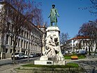
- Diogo Cão (15th century) - navigator
- Gen. José Augusto Alves Roçadas (1865–1926) - colonial governor in Angola
- Carvalho Araújo (1881–1918) - politician and soldier
- Paulo Alves (b. 1969) - football player
- Simão Sabrosa (b. 1979) - football player
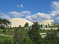
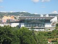
Gallery[]
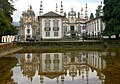
Palácio de Mateus

Panoramic view from the South

Quintela Tower

Agarez Waterfall

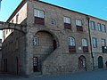
Typical Houses
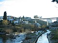
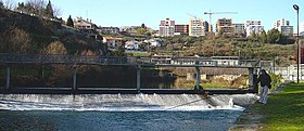
Corgo River and Metallic Bridge in Vila Real

Panóias Sanctuary
Diogo Cão House

Public Library
Theatre
Shopping Centre

Shopping Centre (interior)


References[]
- ^ ITDS, Rui Campos, Pedro Senos. "Statistics Portugal". Ine.pt. Retrieved 2016-07-29.CS1 maint: multiple names: authors list (link)
- ^ "Áreas das freguesias, concelhos, distritos e país". Archived from the original on 2018-11-05. Retrieved 2018-11-05.
- ^ Classificação Expresso das melhores cidades portuguesas para viver em 2007, Expresso
- ^ Insight Guides Portugal (2011 edition).
- ^ "Eu só com este páu, sou capaz de defender Ceuta, de todo o poder dos mouros", as reported in Portugal antigo e moderno, 1878, p. 495.
- ^ Jump up to: a b c "Monthly Averages for Vila Real, Portugal (1971–2000)" (PDF). Instituto de Meteorologia. Retrieved 12 September 2020.
- ^ Gonçalves, Luís Filipe Fernandes. "Caracterização e Exploração do sistema hidromineral sulfúreo das Caldas de Carlão". Porto University. Retrieved 18 January 2021.
- ^ Diário da República. "Law nr. 11-A/2013, pages 552 136-137" (PDF) (in Portuguese). Retrieved 5 August 2014.
- ^ "Futebol Total..: AF Vila Real". Futeboltotal-victor.blogspot.co.uk. Retrieved 2016-07-29.
- ^ "Relações Internacionais". cm-vilareal.pt (in Portuguese). Vila Real. Retrieved 2019-12-12.
External links[]
| Wikisource has the text of the 1911 Encyclopædia Britannica article Villa Real. |
| Wikivoyage has a travel guide for Vila Real. |
- Municipality official website
- University of Trás-os-Montes e Alto Douro
- Vila Real Theatre
- Infantry Regiment no. 13
- Photos from Vila Real
- AeroVIP site (Flights Bragança - Vila Real - Lisboa)
| show Authority control |
|---|
- Cities in Portugal
- Municipalities of Vila Real District
- Vila Real, Portugal