Villeret, Belgium
This article needs additional citations for verification. (October 2016) |
Villeret | |
|---|---|
Hamlet | |
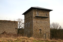 Le donjon de Villeret (the dungeon of Villeret) | |
 Villeret | |
| Coordinates: 50°30′25.39″N 4.°39′11.45″E / 50.5070528°N 4.6531806°ECoordinates: 50°30′25.39″N 4.°39′11.45″E / 50.5070528°N 4.6531806°E | |
| Country | |
| Province | Namur |
| Municipality | Jemeppe-sur-Sambre |
| Elevation | 119 m (390 ft) |
| Time zone | UTC+1 (CET) |
Villeret is a hamlet in the municipality of Jemeppe-sur-Sambre (in the province of Namur), Wallonia Region, Belgium.
Villeret is part of the village of and is located at the confluence of the east flowing Ligny and another stream flowing down from the north (through Bothey).[1] The Ligny then continues eastwards into the Orneau.
Sights[]
- Le [fr] (the dungeon of Villeret) is an ancient tower fortified in the thirteenth century.[2]
- La ferme de Basse-Villeret (the Lower Villeret Farm) dates from the sixteenth century. The current buildings are nineteenth century.
History[]
The hamlet of Villeret was on the extreme-left of the Prussian line during the Battle of Ligny on 16 June 1815. It remained in Prussian possession throughout the battle.[3]
Notes[]
- ^ Siborne 1848, pp. 200–201.
- ^ Donjon de Villeret is located at 50°30′29″N 4°39′03.8″E / 50.50806°N 4.651056°E
- ^ Siborne 1848, pp. 200–201, 210–211.
References[]
- Siborne, William (1848), The Waterloo Campaign, 1815 (4th ed.), Westminster: A. Constable
External links[]
| Wikimedia Commons has media related to Villeret, Belgium. |
- "Villeret Tower", castles.nl, 2016, retrieved 31 October 2016
| Authority control |
|
|---|
This Namur Province location article is a stub. You can help Wikipedia by . |
Categories:
- Populated places in Hainaut (province)
- Battle of Ligny locations
- Namur geography stubs