Vilna Governorate
| Vilna Governorate | |||||||||
|---|---|---|---|---|---|---|---|---|---|
| Governorate of the Russian Empire | |||||||||
| 1795–1915 | |||||||||
 Coat of arms
| |||||||||
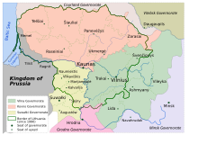 Vilna Governorate (light green), 1843–1915, with modern Lithuania outlined | |||||||||
| Capital | Vilna | ||||||||
| History | |||||||||
| History | |||||||||
| 1795 | |||||||||
| 1915 | |||||||||
| |||||||||
| Today part of | Belarus Lithuania | ||||||||


The Vilna Governorate (1795–1915; also known as Lithuania-Vilnius Governorate from 1801 until 1840; Russian: Виленская губерния, Vilenskaya guberniya, Lithuanian: Vilniaus gubernija, Polish: gubernia wileńska) or Government of Vilnius was a governorate (guberniya) of the Russian Empire created after the Third Partition of the Polish–Lithuanian Commonwealth in 1795. It was part of the Lithuanian General Governorate, which was called the Vilnius General Governorate after 1830, and was attached to the Northwestern Krai. The seat was in Vilnius (Vilna in Russian), where the Governors General resided.
History[]
The first governorates, Vilnius Governorate (consisting of eleven uyezds or districts) and Slonim Governorate, were established after the third partition of the Polish-Lithuanian Commonwealth. Just a year later, on December 12, 1796, by order of Tsar Paul I they were merged into one governorate, called the Lithuanian Governorate, with its capital in Vilnius.[1] By order of Tsar Alexander I on September 9, 1801, the Lithuanian Governorate was split into the Lithuania-Vilnius Governorate and the Lithuania-Grodno Governorate. After 39 years, the word "Lithuania" was dropped from the two names by Nicholas I.[2]
In 1843, another administrative reform took place, creating the Kovno Governorate (Kovno in Russian) out of seven western districts of the Vilnius Governorate, including all of Samogitia. The Vilnius Governorate received three additional districts: Vileyka and Dzisna from the Minsk Governorate and Lida from Grodno Governorate.[3] It was divided to districts of Vilnius, Trakai, Disna, Oshmyany, Lida, Vileyka and Sventiany. This arrangement remained unchanged until World War I. A part of the Vilnius Governorate was then included in the Lithuania District of Ober-Ost, formed by the occupying German Empire.
During the Polish–Soviet War, the area was annexed by Poland. The Council of Ambassadors and the international community (with the exception of Lithuania) recognized Polish sovereignty over the Vilnus region in 1923.[4] In 1923, the Wilno Voivodeship was created, which existed until 1939, when the Soviet Union occupied Lithuania and Poland and returned most, but not all, of the Polish-annexed land to Lithuania.
Demographics[]
In 1834, the Vilnius Governorate had about 789,000 inhabitants; by 1897, the population had grown to about 1,591,000 residents[5] (37 per km2).
| Language | People | %[6][7] |
|---|---|---|
| Belarusian | 891,903 | 56.1% |
| Lithuanian | 279,720 | 17.6% |
| Yiddish | 202,374 | 12.7% |
| Polish | 130,054 | 8.2% |
| Russian | 78,623 | 4.9% |
| German | 3,873 | 0.2% |
| Tatar | 1,969 | 0.1% |
| Ukrainian | 919 | 0.1% |
| Other | 1,119 | 0.1% |
| Total | 1,591,207 | 100% |
Importantly, the census was forged.{{Citation needed}} In 1916 a census by the Germans took place during the German occupation of the region. He showed that Poles constitute 60% of the province's inhabitants. Other nationalities did not exceed 10-20%. In Vilnius, Poles constituted 54% of the city's population, Jews 40%, and Lithuanians did not exceed 1%. In the vicinity of the city, Poles constituted about 75% of the population. After Poland regained independence, this area belonged to Poland - the Polish population grew even more - in 1931, in Vilnius, Poles constituted 66% of the population, in the poviat (powiat wileńsko-trocki, poviat Wilno-Troki, poviat Vilnius-Trakai), i.e. in the vicinity of the city, Poles constituted up to 84% of the population.
Between 1944 and 1946, about 150,000 people, mostly but not all of Polish extraction left the area for Poland (about 10% of this group may have been Lithuanians hoping to escape Soviet rule). Between 1955 and 1959, another 46,000 Polish-speakers left Lithuania (see the Ethnic history of the Vilnius region). Meanwhile, the Jewish population of the area, just as in the rest of Lithuania, was virtually exterminated by the Nazis during World War II. As of 2001, ethnic Lithuanians once again predominated within the city of Vilnius (59%), but the area of the former governorate as a whole remained about 62% Polish, with the percentage of Russians (8.6) and Belarusians (4.4) having dwindled to a tiny minority.
Subdivisions[]
| Uyezds in 1795 | Uyezds in 1843 |
|---|---|
| Ashmiany | |
| Braslaw (since 1835 Novoaleksandrovsk (Zarasai County) | (To Kovno Governorate) |
| (From Minsk Governorate) | Dzisna |
| Kovno County | (To Kovno Governorate) |
| (From Grodno Governorate) | Lida |
| Rossieny County | (To Kovno Governorate) |
| Shavli County | (To Kovno Governorate) |
| Švenčionys | |
| Telshi County | (To Kovno Governorate) |
| Trakai | |
| Ukmergė | (To Kovno Governorate) |
| Upytė (since 1843 Panevėžys) | (To Kovno Governorate) |
| (From Minsk Governorate) | Vileyka |
| Vilna County | |
Ethnic composition[]
Russian authorities periodically performed censuses. However, they reported strikingly different numbers:[8]
| Year | Total | Lithuanians | Poles | Belarusians | Russians | Jews | Other | ||||||
|---|---|---|---|---|---|---|---|---|---|---|---|---|---|
| 1862 | 838,464 | 418,880 | 50% | 154,386 | 18% | 146,431 | 17% | 14,950 | 2% | 76,802 | 9% | 27,035 | 3% |
| 1865 | 891,715 | 210,273 | 24% | 154,386 | 17% | 418,289 | 47% | 27,845 | 3% | 76,802 | 9% | 4,120 | 0% |
| 1883 | 1,192,000 | 417,200 | 35% | 281,312 | 24% | 239,592 | 20% | - | 176,416 | 15% | 77,480 | 7% | |
| 1897 | 1,561,713 | 274,414 | 18% | 126,770 | 8% | 880,940 | 56% | 75,803 | 5% | 197,929 | 13% | 5,857 | 0% |
| 1909 | 1,550,057 | 231,848 | 15% | 188,931 | 12% | 570,351 | 37% | 408,817 | 26% | 146,066 | 9% | 4,094 | 0% |
See also[]
- Ethnic history of the Vilnius region
- History of Vilnius
- Wilno Voivodeship
- Vileyka Voblast
References[]
- ^ Kulakauskas, Antanas (2002). "Administracinės reformos". Gimtoji istorija. Nuo 7 iki 12 klasės (in Lithuanian). Vilnius: Elektroninės leidybos namai. ISBN 9986-9216-9-4. Archived from the original on 2008-03-03. Retrieved 2008-01-01.
- ^ "Литовская губерния". Brockhaus and Efron Encyclopedic Dictionary (in Russian). 1890–1906.
- ^ Simas Sužiedėlis, ed. (1970–1978). "Administration". Encyclopedia Lituanica. I. Boston, Massachusetts: Juozas Kapočius. pp. 17–21. LCC 74-114275.
- ^ Jan Tomasz Gross. Revolution from Abroad: The Soviet Conquest of Poland's Western Ukraine and Western Belorussia. Princeton University Press. 2002. p. 3.
- ^ Vaitiekūnas, Stasys (2006). Lietuvos gyventojai: Per du tūkstantmečius (in Lithuanian). Vilnius: Mokslo ir enciklopedijų leidybos institutas. pp. 79, 92. ISBN 5-420-01585-4.
- ^ "Vilnius governorate - total population".
- ^ Meyers Konversations-Lexikon. 6th edition, Vol. 20, Leipzig and Vienna 1909, pp. 655-656.
- ^ Nikolajew, Christina Juditha (2005). Zum Zusammenhang zwischen nationaler Identitätsbildung und Katholischer Kirche in Litauen (PDF) (in German). Eberhard Karls University of Tübingen. p. 16.[permanent dead link]
| Northwestern Krai | |
|---|---|
| Southwestern Krai |
|

- States and territories established in 1795
- States and territories disestablished in 1915
- Vilna Governorate
- Governorates of the Russian Empire
- History of Vilnius
- Historical regions in Lithuania
- 1795 establishments in the Russian Empire