Viluppuram district
Viluppuram District | |
|---|---|
| Vizhuppuram | |
 | |
 Location of Viluppuram district in Tamil Nadu | |
| Coordinates: 11°57′16.92″N 79°31′39.83″E / 11.9547000°N 79.5277306°ECoordinates: 11°57′16.92″N 79°31′39.83″E / 11.9547000°N 79.5277306°E | |
| Country | |
| State | |
| Municipalities | Viluppuram, Tindivanam |
| Headquarters | Viluppuram |
| Talukas | Gingee, Kandachipuram, , , Tindivanam, Tiruvennainallur, Vanur, , Villupuram |
| Government | |
| • Collector | A. Annadurai, IAS, Radhakrishnan IPS (SP) |
| Area | |
| • Total | 3,725 km2 (1,438 sq mi) |
| Population (2011) | |
| • Total | 2,093,003 |
| • Rank | 11 |
| • Density | 560/km2 (1,500/sq mi) |
| Languages | |
| • Official | Tamil |
| Time zone | UTC+5:30 (IST) |
| PIN | 604xxx, 6056xx, 6062xx |
| Telephone code | 04146, 04147, 04149, 04151, 04153 |
| Vehicle registration | ,TN-16,TN-32[1] |
| Website | viluppuram |

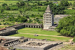
Viluppuram, Villupuram or Vizhuppuram is one of the 38 districts that make up the state of Tamil Nadu, India. It was founded on 30 September 1993, prior to which it was part of the Cuddalore district.[2] Vizhuppuram district lies in the way of the national highway connecting Tiruchirappalli and Chennai, and contains historical landmarks like the 500 year-old Gingee Fort.
History[]
Vizhuppuram district was once a part of the South Arcot district along with the Cuddalore district. Later, the Cuddalore district was bifurcated and Vizhuppuram district came into existence on 30 September 1993. As a result, the Vizhuppuram district's history closely resembles that of Cuddalore's.
The Cholas were among the earliest rulers. Karikala Chola was the most influential. Simhavishnu Pallava overthrew the Cholas, and the region came under the Pallava rule. Vijayalaya Chola restored the rule of Chola, marking the beginning of the Chola Empire.[3]
The entire district became a war zone during the Anglo-French rivalry and it came under the control of the East India Company. It remained under British authority until the independence of India in 1947.[4]
Geography[]
The district shares borders with Bay of Bengal in the east, Puducherry district of the union territory Puducherry in the southeast and the districts Chengalpattu and Tiruvannamalai in the north, Cuddalore in the south and Kallakurichi in the west.
Economy[]
In 2006, the Ministry of Panchayati Raj named Vizhuppuram one of the 250 most backward districts (out of a total of 640) in the country.[5] It is one of the six districts in Tamil Nadu currently receiving funding from the Backward Regions Grant Fund Program (BRGFP).[5]
Taluks[]
Viluppuram district is composed of 9 taluks:[6]
- Gingee
- Kandachipuram
- Tindivanam
- Tiruvennainallur
- Vanur
- Villupuram
Demographics[]
According to 2011 census, the Viluppuram district had a population of 3,458,873 with a sex-ratio of 987 females per 1,000 males, which is well above the national average of 929.[7] A total of 404,106 residents were under the age of six, constituting 208,246 males and 195,860 females. Scheduled Castes and Scheduled Tribes accounted for 29.37% and 2.16% of the population, respectively.
The average literacy of the district was 63.48%, compared to the national average of 72.99%.[7] The district had a total of 800,368 households. There were a total of 1,703,249 workers, including 322,900 farmers, 537,581 farm workers, 23,961 in household industries, 376,360 other workers, 442,447 marginal workers, 46,746 marginal farmers, 294,632 marginal farm workers, 14,276 marginal workers in household industries and 86,793 other marginal workers.[8]
| Year | Pop. | ±% p.a. |
|---|---|---|
| 1901 | 1,237,061 | — |
| 1911 | 1,387,893 | +1.16% |
| 1921 | 1,362,937 | −0.18% |
| 1931 | 1,441,904 | +0.56% |
| 1941 | 1,532,516 | +0.61% |
| 1951 | 1,631,216 | +0.63% |
| 1961 | 1,747,460 | +0.69% |
| 1971 | 2,048,400 | +1.60% |
| 1981 | 2,373,952 | +1.49% |
| 1991 | 2,755,674 | +1.50% |
| 2001 | 2,960,373 | +0.72% |
| 2011 | 3,458,873 | +1.57% |
| source:[9] | ||
See also[]
References[]
- ^ "www.tn.gov.in" (PDF). Archived (PDF) from the original on 12 September 2012. Retrieved 18 December 2011.
- ^ "History | Viluppuram District, Govt of Tamil Nadu | India". Retrieved 21 June 2019.
- ^ "History of India's Chola Empire". ThoughtCo. Retrieved 24 September 2018.
- ^ "History of Viluppuram". Viluppuram Municipality. Archived from the original on 3 November 2015. Retrieved 6 November 2015.
- ^ Jump up to: a b Ministry of Panchayati Raj (8 September 2009). "A Note on the Backward Regions Grant Fund Programme" (PDF). National Institute of Rural Development. Archived from the original (PDF) on 5 April 2012. Retrieved 27 September 2011.
- ^ https://viluppuram.nic.in/about-district/maps/
- ^ Jump up to: a b "Census Info 2011 Final population totals". Office of The Registrar General and Census Commissioner, Ministry of Home Affairs, Government of India. 2013. Archived from the original on 13 November 2013. Retrieved 26 January 2014.
- ^ "Census Info 2011 Final population totals - Viluppuram district". Office of The Registrar General and Census Commissioner, Ministry of Home Affairs, Government of India. 2013. Archived from the original on 24 September 2015. Retrieved 26 January 2014.
- ^ Decadal Variation In Population Since 1901
External links[]
| Wikimedia Commons has media related to Viluppuram district. |
- Official website
- Viluppuram district marked on OpenStreetMap
| show Authority control |
|---|
- Viluppuram district
- 1993 establishments in Tamil Nadu
- Districts of Tamil Nadu