Vir
 Kaštelina castle | |
 | |
| Geography | |
|---|---|
| Location | Adriatic Sea |
| Area | 22.38 km2 (8.64 sq mi) |
| Highest elevation | 112 m (367 ft) |
| Highest point | Bandira |
| Administration | |
| County | Zadar County |
| Largest settlement | Vir |
| Demographics | |
| Population | 3,000[1] (2011) |
Vir (pronounced [v̞îːr]; Italian: Puntadura, Dalmatian: Punta de Ura) is an island on the Croatian coast of the Adriatic Sea with an area of 22 km2.[2] It lies in Dalmatia, north of the city of Zadar. It is connected to the mainland via a road bridge. The main village on the island is the eponymous village of Vir. There are two more villages, Lozice and Torovi.[3] According to the 2011 census, the island had a population of 3,000 inhabitants, making it the 13th most populous island in Croatia.[1]
The highest peak on the island is Bandira (112 m).
History[]
This section needs expansion. You can help by . (February 2014) |
The first known mention of Vir was in Mare Nostrum Dalmaticum (1069), a charter by king Peter Krešimir IV, where the island is referred to as Ueru (Veru), a word believed to have an ancient Mediterranean origin, meaning "pasture".[4]
Tourism[]
Vir is a tourist hotspot. Official statistics in 2018 documented over 80,000 guests from over 70 countries on the island already by the end of July. In 2018, the highest number of foreign tourists was from Slovenia, Germany, Hungary, Slovakia, the Czech Republic, Bosnia and Herzegovina, Poland, Austria, Sweden and Switzerland. With an average of 12.6 overnight stays per tourist, Vir holds the record of the longest time of tourist stays in Croatia.[5]
Overpopulation[]
The island is one of the biggest described endemic places of origin of house-mouse-borne lymphocytic choriomeningitis in the world, with IFA testing having found LCMV antibodies in 36% of the tested population.[6][7]
Gallery[]

Lučica beach
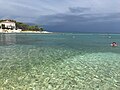
The coast

The Privlaka bridge that connects the island
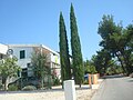
An apartment on the island

A beach on the island

A sunset on Vir


References[]
- ^ Jump up to: a b Ostroški, Ljiljana, ed. (December 2015). Statistički ljetopis Republike Hrvatske 2015 [Statistical Yearbook of the Republic of Croatia 2015] (PDF). Statistical Yearbook of the Republic of Croatia (in Croatian and English). 47. Zagreb: Croatian Bureau of Statistics. p. 47. ISSN 1333-3305. Retrieved 27 December 2015.
- ^ Duplančić Leder, Tea; Ujević, Tin; Čala, Mendi (June 2004). "Coastline lengths and areas of islands in the Croatian part of the Adriatic Sea determined from the topographic maps at the scale of 1 : 25 000" (PDF). Geoadria. Zadar. 9 (1): 5–32. doi:10.15291/geoadria.127. Retrieved 2019-12-17.
- ^ Škrbić, Kažimir (2 May 2017). "Novi asfalt za Lozice i Torove, a javna rasvjeta u svim virskim naseljima" (in Croatian). Antena Zadar. Retrieved 19 August 2018.
- ^ Brkić, Velimir (30 March 2009). "Privatni otok - jučer, danas i sutra". Zadarski list (in Croatian). Retrieved 22 February 2014.
- ^ Škrbić, Kažimir (27 July 2018). "S MILIJUN NOĆENJA OSTVARENIH U SRPNJU JE ZA 14 DANA OBOREN PROŠLOGODIŠNJI REKORD Vir ima najveće povećanje dolazaka i noćenja u Hrvatskoj!" (in Croatian). zadarski.hr. Retrieved 19 August 2018.
- ^ Kalenić, Smilja (2013). Medicinska mikrobiologija [Medical Microbiology] (in Croatian). Zagreb: Medicinska naklada. ISBN 978-953-176-637-1.
- ^ Dobec M, Dzelalija B, Punda-Polic V, Zoric I (2006). "High prevalence of antibodies to lymphocytic choriomeningitis virus in a murine typhus endemic region in Croatia". Journal of Medical Virology. 78 (12): 1643–47. doi:10.1002/jmv.20749. PMID 17063527.
External links[]
| Wikimedia Commons has media related to Island of Vir. |
| show Subdivisions of Zadar County |
|---|

Coordinates: 44°18.20568′N 15°05.13222′E / 44.30342800°N 15.08553700°E

| show Authority control |
|---|
- Islands of Croatia
- Islands of the Adriatic Sea
- Municipalities of Croatia
- Populated places in Zadar County
- Landforms of Zadar County