Vire
Vire, Normandie | |
|---|---|
Part of Vire-Normandie | |
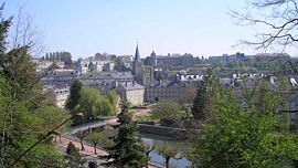 Vire from the Place du Château | |
 Coat of arms | |
show Location of Vire, Normandie | |
 Vire, Normandie | |
| Coordinates: 48°50′N 0°53′W / 48.84°N 0.89°WCoordinates: 48°50′N 0°53′W / 48.84°N 0.89°W | |
| Country | France |
| Region | Normandy |
| Department | Calvados |
| Arrondissement | Vire |
| Canton | Vire |
| Commune | Vire-Normandie |
| Area 1 | 22.50 km2 (8.69 sq mi) |
| Population (2017)[1] | 11,091 |
| • Density | 490/km2 (1,300/sq mi) |
| Time zone | UTC+01:00 (CET) |
| • Summer (DST) | UTC+02:00 (CEST) |
| Postal code | 14500 |
| Elevation | 85–225 m (279–738 ft) (avg. 134 m or 440 ft) |
| 1 French Land Register data, which excludes lakes, ponds, glaciers > 1 km2 (0.386 sq mi or 247 acres) and river estuaries. | |


Vire (French pronunciation: [viʁ] (![]() listen)) is a town and a former commune in the Calvados department in the Normandy region in northwestern France. On 1 January 2016, it was merged into the new commune of Vire-Normandie.[2]
listen)) is a town and a former commune in the Calvados department in the Normandy region in northwestern France. On 1 January 2016, it was merged into the new commune of Vire-Normandie.[2]
Geography[]
The town is located on the river Vire.

History[]
In 1123, Henri I Beauclerc, King of England and Duke of Normandy, had a redoubt constructed on a rocky hill top, which was surrounded by the Vire river. The redoubt was stoned square at the bottom to assure the defense of the Duchy of Normandy against any attacks from Brittany or Maine.[3]
This stone work would be later, At the beginning of the 13th century, Saint Louis ordered that the existing stonework be supplemented with exterior ramparts. However this second precinct was only finished at the beginning of the 14th century.[4]:7
In the old community of Neuville, north of the territory, the castle of Tracy is the seat of an important manor, Arcisse de Caumont.[5]
At the end of the Middle Ages, the village prospered; first with leather, and then with textiles[6] During the Hundred Years' War, Vire was plundered in 1368 by large military companies,[4] and delivered to the English in 1418. The English occupation would end in 1450 and would be brutal to the inhabitants. The execution of Hugues Vaux, owner of the largest farm of the village, after refusing to give up his farm to the English sergeant Fields, caused grief and concern amongst the population. Some inhabitants nevertheless benefited from the English occupation. Eugène Vergny, who provided Fields with information about the movement of the French troops, received the property of Vaux after his execution.[3]
During the reign of Louis XIII of France, because a number of Fortifications of the Middle Ages served in rebellions by the Huguenots in particular, the castle and its precinct were dismantled on orders of Richelieu.[4]:7

During the 19th century, the village did not respond well to the Industrial Revolution and went into an important recession.
On June 6, 1944, during the Second World War, around 8:00 pm, like many Norman cities and villages, Vire suffered heavily from the British bombings, and 95% of the town was destroyed. One of the two target marking flare groups was out of alignment and much of the bombing fell across the town of Vire. The Master Bomber in charge of the operation identified the problem and issued corrections to the incoming aircraft. Much of the bombing from the first wave of aircraft fell across the town of Vire killing many of the inhabitants. It was a distressing night for many families.[7]
The reconstruction after the Second World War began in the 1960s.

Population[]
|
| ||||||||||||||||||||||||||||||||||||||||||||||||||||||||||||||||||||||||||||||||||||||||||||||||||||||||||||||||||
| Source: EHESS/Cassini until 1999,[8] INSEE from 2007[9][10] | |||||||||||||||||||||||||||||||||||||||||||||||||||||||||||||||||||||||||||||||||||||||||||||||||||||||||||||||||||
Administration[]
In 1953, Vire was merged with the former commune of Neuville. In 1972, Vire was merged with the former commune of Saint-Martin-de-Tallevende. Since January 2016, it is a delegated commune within the commune Vire-Normandie.[11] Vire is part of the canton of Vire.[12]
Transport[]
Vire has a large railway station (Gare de Vire) which has frequent services to Paris and Granville. The nearest airport is Caen – Carpiquet Airport in Caen (40 min drive).
Vire is connected to Saint-Lô and Cherbourg-en-Cotentin via RN 174 and to Caen via RD 577 and A84. Vire is also connected to Granville, Villedieu-les-Poêles, Flers, Argentan, Dreux and Paris via RD 924.
Gastronomy[]
- Andouille, a speciality of Vire.
International relations[]
Vire is twinned with:[13]
|
Personalities[]
- Charles-Julien Lioult de Chênedollé
- Henry I of England
- Francis Letellier
- Olivier Basselin
- Thomas Pichon
- Raymond Lefebvre
See also[]
- Communes of the Calvados department
References[]
- ^ Téléchargement du fichier d'ensemble des populations légales en 2017, INSEE
- ^ Arrêté préfectoral 31 December 2015 (in French)
- ^ Jump up to: a b "GASO, la banque du blason - Vire Calvados". Retrieved 8 August 2009.[dead link]
- ^ Jump up to: a b c Buffetaut, Yves (September 2009). "La prise de Vire par les Grandes Compagnies". Itinéraires de Normandie. 15: 60–64. ISSN 1950-9324. Archived from the original on July 13, 2011.
- ^ Arcisse de Caumont, Statistique monumentale du Calvados, editeur= Hardel year= 1857 tome= 3 title: Arrondissements de Vire et de Bayeux passage 92
- ^ "Vire-tourisme : Vire et les alentours consulté le". Archived from the original on September 11, 2008. Retrieved 14 October 2009.
- ^ Coulonces.com - 2009 – David FELL.
- ^ Des villages de Cassini aux communes d'aujourd'hui: Commune data sheet Vire, EHESS. (in French)
- ^ "Populations légales 2012: Commune de Vire (14762)". Retrieved 31 August 2020.
- ^ Téléchargement du fichier d'ensemble des populations légales en 2017, INSEE
- ^ Commune de Vire (14762), commune déléguée, INSEE
- ^ Décret n° 2014-160 du 17 février 2014 portant délimitation des cantons dans le département du Calvados
- ^ Jump up to: a b c d e f g "National Commission for Decentralised cooperation". Délégation pour l’Action Extérieure des Collectivités Territoriales (Ministère des Affaires étrangères) (in French). Archived from the original on 2013-11-27. Retrieved 2013-12-26.
External links[]
| Wikimedia Commons has media related to Vire. |
| Wikisource has the text of the 1911 Encyclopædia Britannica article Vire. |
| show Authority control |
|---|
- Former communes of Calvados (department)