Visalia, California
Visalia, California | |
|---|---|
City | |
| City of Visalia | |
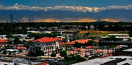    Clockwise: View of Visalia; Bank of Italy Tower; Visalia Transit Center; Fox Theatre | |
 Flag | |
| Nickname(s): Gateway to the Sequoias | |
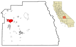 Location within Tulare County in the state of California | |
 Visalia Location in the United States | |
| Coordinates: 36°19′N 119°18′W / 36.317°N 119.300°WCoordinates: 36°19′N 119°18′W / 36.317°N 119.300°W | |
| Country | United States |
| State | California |
| County | Tulare |
| Region | San Joaquin Valley |
| Incorporated | February 27, 1874[1] |
| Government | |
| • Type | Council–manager |
| • City Council | Mayor Steve Nelsen Vice Mayor Phil Cox Brian Poochigan Greg Collins Brett Taylor[2] |
| • City Manager | Randy Groom[3] |
| • Chief of Police | Jason Salazar[4] |
| • Fire Chief | Dan Griswold[5] |
| Area | |
| • Total | 37.94 sq mi (98.25 km2) |
| • Land | 37.91 sq mi (98.20 km2) |
| • Water | 0.02 sq mi (0.05 km2) 0.05% |
| Elevation | 331 ft (101 m) |
| Population (2020) | |
| • Total | 141,384 |
| • Estimate (2019)[8] | 134,605 |
| • Rank | 44th in California 202nd in the United States |
| • Density | 3,550.18/sq mi (1,370.73/km2) |
| Demonym(s) | Visalian |
| Time zone | UTC−8 (PST) |
| • Summer (DST) | UTC−7 (PDT) |
| ZIP code | 93277-93279, 93290-93292 |
| Area code(s) | 559 |
| FIPS code | 06-82954 |
| GNIS feature IDs | 1652807, 2412160 |
| Website | www |


Visalia (/vaɪˈseɪl.jə, vɪ-/ vy-SAYL-yə, vih-)[9][10] is a city in the agricultural San Joaquin Valley of California, about 230 mi (370 km) southeast of San Francisco, 190 mi (310 km) north of Los Angeles, 36 mi (58 km) west of Sequoia National Park, and 43 mi (69 km) south of Fresno. The population was 134,605 as of a 2019 U.S. Census Bureau estimate.
Visalia is the fifth-largest city in the San Joaquin Valley after Fresno, Bakersfield, Stockton, and Modesto, the 44th-most populous in California, and 202nd in the United States.[11]
As the county seat of Tulare County, Visalia serves as the economic and governmental center to one of the most productive agricultural counties in the country.[12]
Yosemite, Sequoia, and Kings Canyon National Parks are located in the nearby Sierra Nevada mountains, the highest mountain range in the contiguous United States.
History[]
The area around Visalia was first settled by the Yokuts and Mono Native American tribes hundreds of years ago.[13] When the first Europeans arrived is unknown, but the first to make a written record of the area was Pedro Fages in 1722.[14]

When California achieved statehood in 1850, Tulare County did not exist. The land that is now Tulare County was part of the vast County of Mariposa.[15] In 1852, some pioneers settled in the area, then called Four Creeks. The area got its name from the many watershed creeks and rivers flowing from the Sierra Nevada Mountains. All the water resulted in a widespread swampy area with a magnificent oak forest. The industrious group of settlers petitioned the state legislature for county status, and on July 10 of that same year, Tulare County became a reality.[16]

One of the first inhabitants of a fort built by the settlers was Nathaniel Vise, who was responsible for surveying the new settlement. In November 1852, he wrote, "The town contains from 60–80 inhabitants, 30 of whom are children of school age. The town is located upon one of the subdivisions of the Kaweah River and is destined to be the county seat of Tulare." In 1853, that prediction became a reality and Visalia has remained the county seat since that time.[17][18] Visalia is named for Nathaniel Vise's ancestral home, Visalia, Kentucky.
Early growth in Visalia can be attributed in part to the gold rush along the Kern River. The gold fever brought many transient miners through Visalia along the way, and when the lure of gold failed to materialize, many returned to Visalia to live their lives and raise families. In 1859, Visalia was added to John Butterfield's Overland Stage route from St. Louis to San Francisco. A plaque commemorating the location can be found at 116 East Main Street. Included in the early citizens were some notorious and nasty individuals who preyed upon the travelers along the Butterfield Stage route. Many saloons and hotels sprouted up around the stage stop downtown and commerce was brisk if a bit risky.[19][20]
The next memorable event was the arrival of the telegraph in 1860. Visalians then could get timely information of the events taking place on the East Coast that would ultimately develop into the Civil War. During the war, many citizens of Visalia could not decide whether Visalia should stand on the side of the North or the South, so they simply had a mini Civil War of their own on Main Street. No one really knows the outcome of the war, but apparently it was concluded to the satisfaction of the participants and life returned to normal. The federal government, however, was not so easily convinced, and reacting to concern about sedition, banned Visalia's pro-South Equal Rights Expositor newspaper and established a military garrison. Camp Babbitt was built in 1862 to stop overt Southern support and maintain law and order in the community. During these Civil War years, Visalia was incorporated, which gave the town new rights.[21]
The second incorporation in 1874 moved Visalia into city status with a common council and an ex-officio mayor and president.[22] In 1893, the train bandits and murderers John Sontag and Chris Evans were apprehended, badly wounded, outside Visalia in what is called the Battle of Stone Corral. Sontag died three weeks later in police custody in Fresno; Evans was sent to Folsom State Prison.[23] In 1904, the Visalia Electric Railroad was incorporated.[24]
In October 1933, Visalia was the site of a fact-finding committee appointed by Governor James Rolph and charged with investigating labor violence in the San Joaquin cotton strike. Labor activist Caroline Decker led hundreds of strikers in a march on the courthouse, and led the questioning of strikers during the investigation. In the mid-1970s, the area was known for the serial burglaries of the then unidentified Visalia Ransacker.[25] More recently, Visalia served as a host city for the Amgen Tour of California in 2009 and 2010.[26]
Cityscape[]

The city is divided into neighborhoods, some of which were incorporated places or communities. Also, several independent cities around Visalia are popularly grouped with the city of Visalia, due to its immediate vicinity. Generally, the city is divided into these areas: Downtown Visalia, North Visalia, the Eastside, Southwest Visalia, the Industrial Area, Mooney, and the Westside.
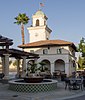
Visalia has a rich architectural history, including many extant buildings dating to the mid- to late 1800s. Throughout the town center are many historic brick structures, including the Bank of Italy (currently Bank of the Sierra) and the Art Deco/Beaux-Arts Visalia Town Center Post Office, both of which are registered with the National Register of Historic Places. In addition to many other historic buildings and Victorian houses, Visalia is also home to a distinctive Fox Theatre, which was restored by a community group known as "Friends of the Fox" and currently serves as a live venue for music and stage performances.[27]
Geography[]

Visalia is irregularly shaped and covers a total area of 36.3 sq mi (94 km2), of which 36.3 square miles (94 km2) are land and 0.05% is covered by water. Visalia is located at 36°19'27" North, 119°18'26" West (36.324100, −119.307347).[28]
The highest point in the Visalia–Porterville area is Mount Whitney.[29] Located at the far reaches of the Sierra Nevada roughly 58 miles (93 km) east of the city, it reaches a height of 14,505 ft (4,421 m). The hilliest parts of the Visalia area are the Venice Hills and the entire Sierra Nevada foothills east of the city. Four main streams run through the city. The major stream is the St. John's River, which begins at the diversion dam in the Kaweah River and is largely seasonal. The others are Mill Creek, Cameron Creek, and Packwood Creek. Many smaller creeks also flow through the city. The Friant-Kern Canal runs just east of the city along the western edge of the Sierra Nevada foothills.
Geology[]
Visalia is subject to earthquakes due to its proximity to the Pacific Ring of Fire. The geologic instability produces numerous fault lines both above and below ground, which altogether cause around 10,000 earthquakes every year.[30] One of the major fault lines is the San Andreas Fault. No major earthquakes have hit the Visalia area.[31] Most quakes are of low intensity and are not felt.[30] The San Joaquin Valley and metropolitan areas are also at risk from blind thrust earthquakes.[32] Parts of the city are also vulnerable to floods.
Climate[]

Visalia has a cold semi-arid climate (BSk, under the Köppen climate classification), and receives just enough annual precipitation to stay out of Köppen's BWk (cold desert climate) classification. Visalia enjoys plenty of sunshine throughout the year, with an average of only 26 days with measurable precipitation annually.[33]
The period of April through October is warm to hot and dry, with typical high temperatures of 74–94 °F (23–34 °C) and lows of 48–65 °F (9–18 °C). However, temperatures frequently exceed 100 °F (38 °C) and occasionally reach 105 °F (41 °C).
The period of November through March is mild and somewhat rainy, with high temperatures of 54–67 °F (12–19 °C) and lows of 36–45 °F (2–7 °C), but temperatures could occasionally drop to high 20s (−3 °C) or be as high as 70 °F (21 °C) for a few days during winter.[34]
Visalia averages 10.93 inches (277.6 mm)[35] of precipitation annually, which mainly occurs during the winter and spring (November through April)[35] with generally light rain showers, but sometimes as heavy rainfall and thunderstorms. Years of average rainfall are rare; the usual pattern is bimodal, with a short string of dry years (perhaps 7–8 in [180–200 mm]) followed by one or two wet years that make up the average. While the Sierra Nevada mountains farther east in Tulare County receive snow every winter, snowfall is extremely rare in Visalia. The greatest snowfall recorded in the city was just below 3 inches (7.62 cm) on January 25, 1999.[36]
| hideClimate data for Visalia, California (1981–2010) | |||||||||||||
|---|---|---|---|---|---|---|---|---|---|---|---|---|---|
| Month | Jan | Feb | Mar | Apr | May | Jun | Jul | Aug | Sep | Oct | Nov | Dec | Year |
| Average high °F (°C) | 54.6 (12.6) |
61.3 (16.3) |
67.3 (19.6) |
73.4 (23.0) |
81.6 (27.6) |
89.1 (31.7) |
94.1 (34.5) |
92.8 (33.8) |
87.7 (30.9) |
78.2 (25.7) |
64.1 (17.8) |
54.5 (12.5) |
75.0 (23.9) |
| Average low °F (°C) | 38.7 (3.7) |
42.1 (5.6) |
46.1 (7.8) |
49.2 (9.6) |
55.7 (13.2) |
61.6 (16.4) |
66.7 (19.3) |
65.0 (18.3) |
60.3 (15.7) |
52.5 (11.4) |
43.5 (6.4) |
37.8 (3.2) |
51.6 (10.9) |
| Average precipitation inches (mm) | 1.91 (49) |
1.85 (47) |
1.99 (51) |
0.94 (24) |
0.35 (8.9) |
0.14 (3.6) |
0.01 (0.25) |
0.01 (0.25) |
0.15 (3.8) |
0.61 (15) |
1.23 (31) |
1.74 (44) |
10.93 (278) |
| Average precipitation days (≥ 0.01 in) | 7.3 | 7.1 | 6.5 | 3.8 | 1.9 | 0.4 | 0.1 | 0.1 | 0.6 | 2.0 | 4.3 | 6.2 | 40.3 |
| Source 1: Temperatures and precipitation totals: Western Regional Climate Center[35] | |||||||||||||
| Source 2: Average precipitation days:[citation needed] | |||||||||||||
Importance of the valley oak[]
Visalia's Valley Oak Ordinance, adopted in 1971,[37] regulates pruning and removing valley oak (Quercus lobata) trees.[38] The area was once a dense oak woodland and the city is trying to maintain a healthy urban forest partly through preserving Mooney Grove Park, one of the largest valley oak groves in California. Also, just outside the city limits is the Kaweah Oaks Preserve, which is a 322-acre (1.3 km2) nature preserve. It protects one of the last remaining valley oak riparian forests in the San Joaquin Valley.
Visalia was the home of the minor league baseball team the Visalia Oaks for almost 30 years. The team's namesake was in recognition of the city's arboreal identity and had the mascot of Oakie, and later Chatter, both gray squirrels.
Environmental issues[]
Owing to geography and heavy reliance on automobiles, Visalia suffers from air pollution in the form of smog and other particulates. The Visalia area and the rest of the San Joaquin Valley are susceptible to atmospheric inversion, which holds in the exhausts from road vehicles, airplanes, locomotives, manufacturing, and other sources. Unlike other cities that rely on rain to clear smog, Visalia gets only 11.03 in (280.16 mm) of rain each year; pollution accumulates over many consecutive days. Issues of air quality in Visalia and other major cities led to the passage of early national environmental legislation, including the Clean Air Act. More recently, the state of California has led the nation in working to limit pollution by mandating low emission vehicles. Particulate pollution can also be high during the winter due to frequent low-level inversions and during longer periods of dry weather. The same low-level inversions that cause high pollution levels in the winter also cause the frequent dense fog, locally known as Tule fog.
As a result, pollution levels have dropped in recent decades. The number of stage 1 smog alerts has declined from over 100 per year in the 1970s to almost zero in the new millennium. Despite improvement, the 2006 annual report of the American Lung Association ranked the city as the 11th-most polluted in the country with short-term particle pollution and year-round particle pollution.[39] In 2007, the annual report of the American Lung Association ranked the city as the fourth-most polluted in the country with short-term particle pollution and year-round particle pollution.[40] In 2008, the city was ranked the third-most polluted and again fourth for highest year-round particulate pollution.[41]
Economy[]
The economy of Visalia is driven by agriculture (especially grapes, olives, cotton, citrus, and nursery products), livestock, and distribution and manufacturing facilities (electronics and paper products are significant manufacturing sectors).[42] Light manufacturing and industrial/commercial distribution represent the fastest growing portion of Visalia's employer base.[43]
According to the Visalia Economic Development Corporation,[44] the top-10 employers in the city are, in descending order, Tulare County, Kaweah Delta Medical Center, College of the Sequoias, Family Healthcare Network, the City of Visalia, VF, International Paper, Jostens, Cigna, and Visalia Medical Clinic.
Culture[]
In popular culture[]
- Visalia was featured in several episodes of season two of the TV series 24, though many characters mispronounced its name. When the show was supposedly showing downtown Visalia, residents noticed there were Los Angeles palm trees in the scene.
- Ken Park, a controversial 2002 film directed by Larry Clark and Edward Lachman, was filmed on location in Visalia. Never released in the United States, the film is much better known in Europe and abroad.
- Kevin Costner attended Mt. Whitney High School for one semester in Visalia. His movie Bull Durham mentions the town's professional baseball team, the Visalia Oaks (now the Visalia Rawhide), which has been in Visalia for more than 60 years (book-ending a brief stint of the team as the Central Valley Rockies).
- As a minor league team for the Oakland A's, the Visalia Oaks were mentioned twice during the 2011 movie Moneyball.
- The town is also mentioned in the book They Say, in which Ida B. Wells comments on the town being a hot and dusty small village.
- In the film Big Trouble in Little China, Jack Burton's trucking company hails from Visalia. It can be seen on the passenger-side door early in the film.
- Visalia appears in the video game Grand Theft Auto: San Andreas where it is parodied as Montgomery.
Media[]
The major daily newspaper in the area is the owned by Gannett. A number of smaller regional newspapers, alternative weeklies, and magazines are published, including the Valley Voice. Many cities adjacent to Visalia also have their own daily newspapers whose coverage and availability overlaps into certain Visalia neighborhoods.
Sports[]
Visalia is home to the Visalia Rawhide (a "high-A" class team of the Arizona Diamondbacks) of Minor League Baseball. The Rawhide compete in the California League at Recreation Park.[45]
It is also home to the Visalia Vapor Trailers, the longest-active official National Hot Rod Association (NHRA) car club.[46]

Religion[]
About 233,293 Christians are in the metropolitan area (85,000 in the city proper).[47][48] Churches of the Catholic, Methodist, Presbyterian. Lutheran, Baptist, Church of Christ, Assemblies of God, Church of Jesus Christ of Latter-day Saints, Pentecostal, Seventh-day Adventist Church, Eastern Orthodox Church, Oriental Orthodox Church, Mennonite, and other denominations can be found throughout the city. Some of the larger Protestant Christian congregations include Radiant Church, Visalia First Assembly, Neighborhood Church, Gateway Church, Grace Community Church, Christ Lutheran Church, Visalia Nazarene Church, and Visalia Community Covenant Church.
Visalia has a multiethnic population practicing a variety of faiths, including Judaism, Islam, Buddhism, Hinduism, Zoroastrianism, Sikhism, Baháʼí, Sufism. Immigrants from Southeast Asia have formed the Lao Buddhist Temple of Visalia, one of two Buddhist temples in the Visalia Area.
Education[]
Colleges and universities[]

College of the Sequoias, a community college, is the only public college located in Visalia.
Universities with branch campuses located within the city limits:
- Fresno State
- Chapman University
- Fresno Pacific University
- Brandman University
Private colleges in Visalia include:
- San Joaquin Valley College
- University of Phoenix
Visalia is the only major city in the Central Valley with a population over 100,000 that does not have a local four-year university.[49][failed verification]
Visalia is also the largest primary statistical area in the United States without an NCAA member school.[citation needed]
Schools and libraries[]
Visalia Unified School District serves the entire city of Visalia, as well as several surrounding communities, with a student population of about 30,000.[50] The Tulare County Public Library operates its largest branch, the Visalia Branch, in Downtown Visalia. There are other smaller libraries in Visalia, such as the Visalia Learning Center.
Transportation[]
Freeways and highways[]
California State Route 99, known as the Pearl Harbor Survivors Memorial Freeway, is the major north–south highway that heads north to Fresno and south to Bakersfield. California State Route 198, the Sequoia Freeway, runs east to Sequoia National Park and west to San Lucas. California State Route 63, Mooney Boulevard, heads north towards Orosi and Kings Canyon National Park, and south to Tulare. California State Route 216, Lovers Lane, heads east to Woodlake.
Public transportation[]
The Visalia Transit (formerly Visalia City Coach) operates public transportation to, from and within the communities of Visalia, Goshen, Farmersville and Exeter.[51] The Visalia Transit also provides Dial-A-Ride curb-to-curb para-transit service on a shared-ride, demand-response basis to locations within the city limits of Visalia, Goshen and Farmersville.[52]
The Tulare County Area Transit (TCaT) provides the public transit services between Visalia and smaller communities throughout the greater Visalia area. Service includes Fixed Route and Demand Responsive services that are offered Monday through Saturday.[53]
Orange Belt Stages has a bus stop in Visalia for commuting Amtrak rail passengers with Visalia as their final destination. The nearest Amtrak stations that offer commercial rail transportation services are located in Hanford and Fresno. The Sequoia Shuttle provides an alternative form of transportation from Visalia and Three Rivers to Sequoia National Park.[54]
The Loop is an easy, safe and free way for all school-aged kids to get to community centers and recreation centers throughout Visalia where activities for youth are happening.[55]
In late 2015, city officials unveiled the V-Line, a bus line that connects Visalia and Fresno. Its stops, in order, are the Visalia Transit Center, Visalia Municipal Airport, Yosemite International Airport, Fresno State University, and Fresno Courthouse. The bus fare is $10 each way. There are offers ranging from discounted to free for students, seniors, and disabled riders. This bus line has several amenities such as free WiFi and charging ports.[56]

Air transportation[]
Visalia has one airport, the Visalia Municipal Airport (IATA: VIS, ICAO: KVIS, FAA LID: VIS).
Other nearby commercial airports include:
- (IATA: FAT, ICAO: KFAT, FAA LID: FAT) Fresno Yosemite International Airport, owned by the city of Fresno; serves the San Joaquin Valley.
- (IATA: TLR, ICAO: KTLR, FAA LID: TLR) Mefford Field Airport, owned by the city of Tulare
- (IATA: PTV, ICAO: KPTV, FAA LID: PTV) Porterville Municipal Airport, owned by the city of Porterville; serves the Southeastern Sierra Nevada and the South Valley of the Porterville area
- (IATA: BFL, ICAO: KBFL, FAA LID: BFL) Meadows Field Airport, also known as Kern County Airport #1, serves the South Valley
Demographics[]
| Historical population | |||
|---|---|---|---|
| Census | Pop. | %± | |
| 1860 | 548 | — | |
| 1870 | 913 | 66.6% | |
| 1880 | 1,412 | 54.7% | |
| 1890 | 2,885 | 104.3% | |
| 1900 | 3,085 | 6.9% | |
| 1910 | 4,550 | 47.5% | |
| 1920 | 5,753 | 26.4% | |
| 1930 | 7,263 | 26.2% | |
| 1940 | 8,904 | 22.6% | |
| 1950 | 11,749 | 32.0% | |
| 1960 | 15,791 | 34.4% | |
| 1970 | 27,130 | 71.8% | |
| 1980 | 49,729 | 83.3% | |
| 1990 | 75,636 | 52.1% | |
| 2000 | 91,565 | 21.1% | |
| 2010 | 124,442 | 35.9% | |
| 2019 (est.) | 134,605 | [8] | 8.2% |
| U.S. Decennial Census[57] | |||
The 2010 United States Census[58] reported that Visalia had a population of 124,442. The population density was 3,431.4 people per square mile (1,324.9/km2). The racial makeup of Visalia was 80,203 (64.5%) White, 2,627 (2.1%) African American, 1,730 (1.4%) Native American, 6,768 (5.4%) Asian, 164 (0.1%) Pacific Islander, 27,249 (21.9%) from other races, and 5,701 (4.6%) from two or more races. There were 57,262 people (46.0%) people of Hispanic or Latino origin, of any race.
The Census reported that 123,116 people (98.9% of the population) lived in households, 606 (0.5%) lived in non-institutionalized group quarters, and 720 (0.6%) were institutionalized.
There were 41,349 households, out of which 18,102 (43.8%) had children under the age of 18 living in them, 21,219 (51.3%) were opposite-sex married couples living together, 6,508 (15.7%) had a female householder with no husband present, 2,909 (7.0%) had a male householder with no wife present. There were 3,282 (7.9%) unmarried opposite-sex partnerships. 8,383 households (20.3%) were made up of individuals, and 3,330 (8.1%) had someone living alone who was 65 years of age or older. The average household size was 2.98. There were 30,636 families (74.1% of all households); the average family size was 3.42.
The population was spread out, with 37,406 people (30.1%) under the age of 18, 12,461 people (10.0%) aged 18 to 24, 33,922 people (27.3%) aged 25 to 44, 27,779 people (22.3%) aged 45 to 64, and 12,874 people (10.3%) who were 65 years of age or older. The median age was 31.6 years. For every 100 females, there were 95.2 males. For every 100 females age 18 and over, there were 92.1 males.
There were 44,205 housing units at an average density of 1,218.9 per square mile (470.6/km2), of which 25,380 (61.4%) were owner-occupied, and 15,969 (38.6%) were occupied by renters. The homeowner vacancy rate was 2.6%; the rental vacancy rate was 6.7%. 73,980 people (59.4% of the population) lived in owner-occupied housing units and 49,136 people (39.5%) lived in rental housing units.
2006–2008[]
According to the 2006–2008 American Community Survey, the racial composition of Visalia was as follows:
- White: 84.0% (Non-Hispanic Whites: 50.0%)
- Black or African American: 2.2%
- Native American: 1.8%
- Asian: 5.0%
- Native Hawaiian and Other Pacific Islander: 0.1%
- Some other race: 7.6%
- Two or more races: 2.9%
- Hispanic or Latino (of any race): 40.6%
African Americans make up 2.2% of Visalia's population. According to the survey, there were 2,574 African Americans residing in Visalia.
Native Americans make up 0.7% of Visalia's population. According to the survey, there were 827 Native Americans residing in Visalia.
Asian Americans make up 5.0% of Visalia's population. According to the survey, there were 5,762 Asian Americans residing in Visalia. The seven largest Asian American groups were the following:
- Other Asian (Cambodian, Laotian, Thai, Hmong, Lahu, Mien, etc.): 2.7% (3,092)
- Vietnamese: 0.7% (804)
- Filipino: 0.5% (597)
- Chinese: 0.4% (500)
- Indian: 0.4% (437)
- Japanese: 0.2% (237)
- Korean: 0.1% (97)
Pacific Islander Americans make up 0.1% of Visalia's population. According to the survey, there were 138 Pacific Islander Americans residing in Visalia.
Multiracial Americans make up 2.9% of Visalia's population. According to the survey, there were 3,350 multiracial Americans residing in Visalia. The four main multiracial groups were the following:
- White & Black: 0.4% (468)
- White & Native American: 0.9% (1,007)
- White & Asian: 0.5% (534)
- Black & Native American: 0.1% (68)
Hispanics and Latinos make up 40.6% of Visalia's population. According to the survey, there were 47,251 Hispanics and Latinos residing in Visalia. The four main Hispanic/Latino groups were the following:
- Mexican: 38.2% (44,397)
- Puerto Rican: 0.2% (177)
- Cuban: 0.1% (91)
- Other Hispanic or Latino (Guatemalan, Salvadoran, Honduran, etc.): 2.2% (2,586)
White Americans make up 84.0% of Visalia's population. According to the survey, there were 97,735 White Americans residing in Visalia. Much of the European American population is of German, Irish, English, Italian, Russian, Polish, and French descent.
Source:[59]
According to the 2006–2008 American Community Survey, the top ten European ancestries were the following:
- German: 8.2% (9,486)
- English: 6.4% (7,445)
- Irish: 5.8% (6,726)
- Portuguese: 2.5% (2,983)
- Italian: 2.4% (2,792)
- French: 2.0% (2,278)
- Dutch: 1.6% (1,877)
- Scottish: 1.0% (1,178)
- Scotch-Irish: 0.8% (953)
- Polish: 0.7% (820)
Source:[60]
2000[]
The 2000 census[61] recorded 91,565 people, 30,883 households, and 22,901 families residing in the city, with a population density of 3,203.8 people per square mile. There were 32,658 housing units. As of the 2000 US Census, the racial distribution in Visalia was 54.9% White American, 2.3% African American, 6.0% Asian American, 2.4% Native American, 0.3% Pacific Islander, 20.3% from other races, and 4.2% from two or more races. 35.6% of the population was Hispanic or Latino (of any race).[62]
The census indicated that 70.9% spoke English, 12.1% Spanish, 1.0% Lahu, 0.8% Mien, 0.7% Hmong, 0.6% Laotian and 0.5% Tagalog as their first language.[63]
According to the census, 41.1% of households had children under 18, 54.9% were married couples, 14.9% had a female householder with no husband present, and 25.8% were non-families. 20.7% of households were made up of individuals, and 8.4% had someone living alone who was 65 years of age or older. The average household size was 2.91 and the average family size 3.37.[61]
The age distribution was: 31.3% under 18, 9.6% from 18 to 24, 28.5% from 25 to 44, 19.7% from 45 to 64, and 10.9% who were 65 or older. The median age was 32. For every 100 females, there were 99.4 males. For every 100 females aged 18 and over, there were 88.9 males.[61]
The median income for a household was $53,975, and for a family was $61,823. Males had a median income of $46,423, females $34,265. The per capita income was $23,751. 14.8% of the population and 13.2% of families were below the poverty line. 21.4% of those under the age of 18 and 9.4% of those aged 65 or older were below the poverty line.[64]
Government[]
Local government[]

Like much of the San Joaquin Valley, more resident voters are registered in the Republican Party than the Democratic Party.
Of the 51,718 registered voters in Visalia; approximately 31.9% are Democrats and 49.1% are Republicans. The remaining 19.0% are Independents or are registered with one of the many smaller political parties, like the Green Party or the Libertarian Party.[65]
Visalia is a charter city with a city charter approved by the electorate that acts as a "constitution" for the city.[66] Until the November 2012 elections, Visalia voters at large, elected the five-member City Council that serves as the city's legislative and governing body. The city council members serve four-year terms, and they select one member to serve as mayor and one to serve as vice mayor. The City Council hires a powerful city manager that serves as executive officer, administers city operations, and carries out city policies. Every odd-numbered year either two or three members are elected by the people to serve a four-year term. Each March, the City Council meets and chooses one of its members as mayor and one as vice-mayor. The current mayor of Visalia is Bob Link and vice mayor is Steve Nelsen.
The City of Visalia had been threatened with a lawsuit from a network of civil-rights attorneys claiming the city violated the California Voting Rights Act, passed into law in 2002. On March 5, 2012, the Visalia City Council voted to put on the November 2012 ballot an initiative that changed the way that Visalia voters get to elect their city council.[67] The measure passed and since the November 2016 elections, Visalia holds district elections in which the candidates must live in one of the five areas (or "districts") forming the city, and only residents of that area cast their votes.[68]
List of mayors[]
This is a list of Visalia mayors by year.
- 2003-2005 Bob Link[69]
- 2009-2011 Bob Link[69]
- 2011-2013 Amy Shuklian[70]
- December 2016 – 2018 E. Warren Gubler[69][71]
State and federal representation[]
In the California State Legislature, Visalia is in the 16th Senate District, represented by Republican Shannon Grove, and in the 26th Assembly District, represented by Republican Devon Mathis.[72]
In the United States House of Representatives, Visalia is in California's 22nd congressional district, represented by Republican Devin Nunes.[73]
Infrastructure[]
Post Office[]

The United States Postal Service operates the Town Center Post Office at 111 West Acequia Avenue,[74] the Visalia Post Office at 2345 West Beech Avenue,[75] and the Millennium Post Office at 100 North Akers Street.[76][77] The Town Center Post Office received listing in the National Register of Historic Places on January 11, 1985.[78]
Notable people[]
Sister cities[]
 Putignano, Italy
 Miki, Japan
See also[]
- Central California
- List of cities and towns in California
References[]
- ^ "California Cities by Incorporation Date". California Association of Local Agency Formation Commissions. Archived from the original (Word) on November 3, 2014. Retrieved August 25, 2014.
- ^ "City Council". City of Visalia. Retrieved March 26, 2017.
- ^ "City Manager". City of Visalia. Retrieved January 4, 2018.
- ^ "Chief's Bio". City of Visalia. Retrieved May 1, 2015.
- ^ "Fire Chief Bio". City of Visalia. Retrieved April 26, 2016.
- ^ "2019 U.S. Gazetteer Files". United States Census Bureau. Retrieved July 1, 2020.
- ^ "Visalia". Geographic Names Information System. United States Geological Survey. Retrieved October 10, 2014.
- ^ Jump up to: a b "Population and Housing Unit Estimates". Retrieved May 21, 2020.
- ^ "Visalia". The American Heritage Dictionary of the English Language (5th ed.). Boston: Houghton Mifflin Harcourt.
- ^ "Visalia". Dictionary.com Unabridged. Random House.
- ^ "Table 1: Annual Estimates of the Population for Incorporated Places Over 100,000, Ranked by July 1, 2005 Population: April 1, 2000 to July 1, 2005". 2008 Population Estimates. United States Census Bureau, Population Division. June 20, 2006. Archived from the original (CSV) on February 9, 2010. Retrieved January 26, 2007.
- ^ "Agriculture - Tulare County Economic Development Office". Tularecounty.ca.gov. Archived from the original on May 18, 2013. Retrieved October 24, 2012.
- ^ The Tulare County Chamber of Commerce. A Few Facts about Tulare County California: History of Tulare County. Visalia, California. 1959. 11.
- ^ "Downtown Visalia Statistics". Downtownvisalia.com. Retrieved October 24, 2012.
- ^ "Tulare County, California Genealogical Records Information". Mycaliforniagenealogy.com. Archived from the original on October 9, 2009. Retrieved October 24, 2012.
- ^ "CERES: State Historical Landmarks for Tulare County - NO.410 CHARTER OAK OR ELECTION TREE". Ceres.ca.gov. Archived from the original on January 4, 2013. Retrieved October 24, 2012.
- ^ "Historic California Posts: Fort Visalia". Militarymuseum.org. Retrieved October 24, 2012.
- ^ California Genealogy & History Archives Archived December 18, 2014, at the Wayback Machine
- ^ California Genealogy & History Archives Archived December 18, 2014, at the Wayback Machine
- ^ "Butterfield Overland Mail Stage Route" (PDF). Retrieved October 24, 2012.
- ^ "Pioneer life: The telegraph arrives, and war continues". Visaliatimesdelta.com. Archived from the original on September 30, 2011. Retrieved October 24, 2012.
- ^ "Visalia, Tulare County". Carnegie-libraries.org. Retrieved October 24, 2012.
- ^ Duke, Thomas Samuel (1910). "SONTAG AND EVANS, NOTORIOUS TRAIN ROBBERS, MURDERERS AND JAIL BREAKERS. (From Police Records and George Sontag's Statement to the Author.)". Celebrated Criminal Cases of America. San Francisco: James H. Barry Company. pp. 276–286. OCLC 3811019. Retrieved November 29, 2012.
By Thomas Samuel Duke, Captain of Police, San Francisco; Published with Approval of the Honorable Board of Police Commissioners of San Francisco, 1910. (Public Domain Free Download)
- ^ "Visalia Electric". Donsdarkroom.com. Archived from the original on June 6, 2013. Retrieved October 24, 2012.
- ^ Rupe, Megan (March 16, 2018). "National network shining light on more than 40-year Visalia cold case". YOURCENTRALVALLEY. Retrieved April 23, 2018.
- ^ "AMGEN Tour of California". AMGEN Tour of California. Retrieved October 24, 2012.
- ^ "Fox Restoration" (PDF). Archived from the original (PDF) on June 17, 2012. Retrieved September 9, 2012.
- ^ "US Gazetteer files: 2010, 2000, and 1990". United States Census Bureau. February 12, 2011. Retrieved April 23, 2011.
- ^ "Mount Whitney - Britannica Online Encyclopedia". Original.britannica.com. Retrieved November 21, 2009.
- ^ Jump up to: a b "Earthquake Facts". Earthquake.usgs.gov. Archived from the original on February 26, 2009. Retrieved October 24, 2012.
- ^ "Visalia". Consrv.ca.gov. March 23, 2007. Archived from the original on May 18, 2013. Retrieved October 24, 2012.
- ^ "Earthquake and Volcano Deformation and Stress Triggering Research Group home page". Quake.usgs.gov. Archived from the original on November 3, 2008. Retrieved October 6, 2008.
- ^ "Weatherbase: Historical Weather for Visalia, California, United States of America". Weatherbase.com. Retrieved January 21, 2009.
- ^ "National and Local Weather Radar, Daily Forecast, Hurricane and information from The Weather Channel and weather.com". The Weather Channel.
- ^ Jump up to: a b c "VISALIA, CALIFORNIA - Climate Summary - NCDC 1981-2010 Monthly Normals". Western Regional Climate Center. Retrieved May 31, 2019.
- ^ Durfee, Kevin. "Two Rare Snow Events in the San Joaquin Valley". Archived from the original on March 20, 2012. Retrieved November 21, 2009.
- ^ "Urban Forestry FAQ's". City of Visalia. Retrieved May 31, 2019.
- ^ "Valley Oak Tree Ordinance". City of Visalia. Retrieved May 31, 2019.
- ^ People at Risk In 25 U.S. Cities Most Polluted by Short-Term Particle Pollution. Archived January 22, 2009, at the Wayback Machine American Lung Association. Retrieved on January 5, 2007.
- ^ People at Risk In 25 U.S. Cities Most Polluted by Year-Round Particle Pollution. Archived January 22, 2009, at the Wayback Machine American Lung Association. Retrieved on January 5, 2007.
- ^ "City Mayors: The most polluted US cities". www.citymayors.com.
- ^ "Employment and Industries in the Visalia, California Area". Citytowninfo.com. Retrieved October 24, 2012.
- ^ "Visalia Economic Development Corporation". Visaliaedc.com. Archived from the original on May 30, 2013. Retrieved October 24, 2012.
- ^ "Visalia Economic Development Corporation Top Employers". Archived from the original on May 30, 2013.
- ^ "Visalia Rawhide: Home". Web.minorleaguebaseball.com. August 28, 2012. Archived from the original on January 14, 2012. Retrieved October 24, 2012.
- ^ Burgess, Phil, National Dragster editor. "The Drag-on Lady: Racer, pioneer, mom", written April 30, 2008, at NHRA.com (retrieved September 25, 2018)
- ^ "Visalia, California (CA) Detailed Profile". City-data.com. Retrieved October 24, 2012.
- ^ "Tulare County, California (CA) Detailed Profile". City-data.com. Retrieved October 24, 2012.
- ^ "Visalia, California". Retrieved February 8, 2013.
- ^ "US Census, District information". Census.gov. November 29, 2011. Archived from the original on December 25, 2008. Retrieved October 24, 2012.
- ^ "Visalia Transit, Green Line, Sequoia Shuttle, Visalia Towne Trolley". www.ci.visalia.ca.us.
- ^ "Dial-A-Ride". Ci.visalia.ca.us. Retrieved October 24, 2012.
- ^ "Tulare County Area Transit – Transportation for Tulare, Visalia, Dinuba, Porterville, and Delano". Retrieved January 22, 2020.
- ^ "Home". Sequoia Shuttle. Retrieved January 22, 2020.
- ^ "The Loop". Ci.visalia.ca.us. Retrieved October 24, 2012.
- ^ "V-Line". Visalia Times Delta. November 17, 2015.
- ^ "Census of Population and Housing". Census.gov. Retrieved June 4, 2015.
- ^ "2010 Census Interactive Population Search: CA - Visalia city". U.S. Census Bureau. Archived from the original on July 15, 2014. Retrieved July 12, 2014.
- ^ "ACS Demographic and Housing Estimates: 2006-2008: Visalia city, California". 2006-2008 American Community Survey. United States Census Bureau. Archived from the original on July 19, 2011. Retrieved November 7, 2010.
- ^ "Selected Social Characteristics in the United States: 2006-2008: Visalia city, California". 2006-2008 American Community Survey. United States Census Bureau. Archived from the original on July 19, 2011. Retrieved November 6, 2010.
- ^ Jump up to: a b c "U.S. Census website". United States Census Bureau. Retrieved January 31, 2008.
- ^ "Census 2000 Demographic Profile Highlights for Visalia, California". United States Census Bureau. 2000. Archived from the original on February 10, 2020. Retrieved November 6, 2008.
- ^ Modern Language Association Data Center Results of Visalia, California Modern Language Association
- ^ "Selected Social Characteristics in the United States: 2006-2008: Visalia city, California". 2006-2008 American Community Survey. United States Census Bureau. Archived from the original on February 10, 2020. Retrieved November 6, 2010.
- ^ "politicalsub.xls" (PDF). Archived from the original (PDF) on October 17, 2012. Retrieved October 24, 2012.
- ^ "City of Visalia - City Council". Ci.visalia.ca.us. Retrieved October 24, 2012.
- ^ [1][dead link]
- ^ "City of Visalia - District Elections 2016".
- ^ Jump up to: a b c Hernandez, Luis (December 16, 2016). "Gubler is Visalia's mayor". visaliatimesdelta.com. Retrieved July 16, 2020.
- ^ ourvalleyvoice Com https://www.ourvalleyvoice.com/2016/12/17/visalia-council-says-goodbye-shuklian-elects-new-mayor/. Retrieved July 16, 2020. Missing or empty
|title=(help) - ^ Doe, Catherine (2016). "Visalia Council Says Goodbye to Shuklian, Elects New Mayor". ourvalleyvoice.com. Retrieved July 16, 2020.
- ^ "Statewide Database". UC Regents. Archived from the original on February 1, 2015. Retrieved November 30, 2014.
- ^ "California's 22nd Congressional District - Representatives & District Map". Civic Impulse, LLC. Retrieved October 6, 2014.
- ^ "Post Office Location - VISALIA." United States Postal Service. Retrieved on October 29, 2009.
- ^ "Post Office Location - VISALIA." United States Postal Service. Retrieved on October 29, 2009.
- ^ "Post Office Location - VISALIA." United States Postal Service. Retrieved on October 29, 2009.
- ^ "Official Zoning Map." City of Visalia. Retrieved on October 29, 2009.
- ^ "National Register Information System". National Register of Historic Places. National Park Service. July 9, 2010.
Further reading[]
External links[]
 Definitions from Wiktionary
 Media from Wikimedia Commons
 News from Wikinews
 Quotations from Wikiquote
 Texts from Wikisource
 Textbooks from Wikibooks
 Resources from Wikiversity
- Official website

- Experience Visalia
- Visalia Chamber of Commerce
- Visalia Convention & Visitors Bureau
- Visalia Magazine
 Visalia travel guide from Wikivoyage
| show Articles Related to Visalia |
|---|


| show Authority control |
|---|
- Visalia, California
- 1874 establishments in California
- Butterfield Overland Mail in California
- Cities in Tulare County, California
- County seats in California
- Incorporated cities and towns in California
- Populated places established in 1874
- San Joaquin Valley
- Stagecoach stops in the United States