Vlčí hora
This article does not cite any sources. (March 2019) |
| Vlčí hora | |
|---|---|
 Vlčí hora von Norden, Blick von Panský | |
| Highest point | |
| Elevation | 580.6 m n.m. (1,905 ft) |
| Coordinates | 50°56′23″N 14°27′55″E / 50.93972°N 14.46528°ECoordinates: 50°56′23″N 14°27′55″E / 50.93972°N 14.46528°E |
| Geography | |
 Vlčí hora | |
| Parent range | Bohemian Switzerland |
| Geology | |
| Mountain type | cone mountain |
| Type of rock | granite with basalt intrusion |

The Vlčí hora (German: Wolfsberg, 581 m) is one of the most prominent peaks in the lowlands of the Šluknov Hook (Šluknovsko) in the Czech Republic.
Location and area[]
The Vlčí hora is located in the Šluknov Hook, six kilometres west of Rumburk immediately on the edge of the forest and rock landscape of the Bohemian Switzerland. At its foot are the municipalities of Staré Křečany (Alt Ehrenberg) with the village of (Zeidler), and Krásná Lípa (Schönlinde) with its villages of (Schnauhübel), (Wolfsberg) and (Gärten). The summit is crowned by an old mountain hut with an observation tower. At the eastern foot of the mountain is the Veronica Well (Veronikabrunnen or Verunčina studánka). Immediately north of the mountain is the source region of the River Mandau.
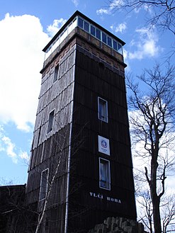
Observation tower
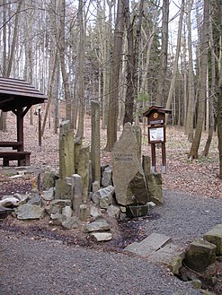
Veronica Well


| Authority control: National libraries |
|---|
- Mountains and hills of Bohemian Switzerland
- Towers in the Czech Republic
- Děčín District