Voula
Voula
Βούλα | |
|---|---|
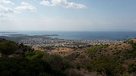 View of Voula | |
 Voula Location within the regional unit  | |
| Coordinates: 37°51′N 23°45′E / 37.850°N 23.750°ECoordinates: 37°51′N 23°45′E / 37.850°N 23.750°E | |
| Country | Greece |
| Administrative region | Attica |
| Regional unit | East Attica |
| Municipality | Vari-Voula-Vouliagmeni |
| • Municipal unit | 8.787 km2 (3.393 sq mi) |
| Elevation | 5 m (16 ft) |
| Population (2011)[1] | |
| • Municipal unit | 28,364 |
| • Municipal unit density | 3,200/km2 (8,400/sq mi) |
| Time zone | UTC+2 (EET) |
| • Summer (DST) | UTC+3 (EEST) |
| Postal code | 166 73 |
| Area code(s) | 210 |
| Vehicle registration | Z |
| Website | www.dimosvoulas.gr |

Voula (Greek: Βούλα) is town and former municipality in East Attica, Greece. Since the 2011 local government reform it is part of the municipality Vari-Voula-Vouliagmeni, of which it is the seat and a municipal unit.[2] The municipal unit has an area of 8.787 km2.[3] Grigoris Konstantellos is the incumbent mayor, elected for a second term at May 26, 2019, for the unified municipality of Vari-Voula-Vouliagmeni.
Geography[]
Voula is a southern suburb of Athens, 16 km south of the city centre. It is located on the Saronic Gulf coast, at the southwestern foot of the Hymettus mountain. Adjacent coast towns are Glyfada to the northwest and Vouliagmeni to the south. The Greek National Road 91 (Athens - Sounio) passes through Voula. One of the largest hospitals in the Athens conurbation, "Asklipieio", lies in the northern part of Voula. It is served by the southern terminus of the Athens Tram lines 3 and 5, Asklipieio Voulas.
Climate[]
Voula has a hot semi-arid climate (Köppen climate classification: BSh), bordering on a hot-summer Mediterranean climate (Köppen climate classification: Csa). Voula experiences hot, dry summers and mild, wetter winters.
| Climate data for Voula | |||||||||||||
|---|---|---|---|---|---|---|---|---|---|---|---|---|---|
| Month | Jan | Feb | Mar | Apr | May | Jun | Jul | Aug | Sep | Oct | Nov | Dec | Year |
| Average high °C (°F) | 13.12 (55.62) |
13.54 (56.37) |
15.53 (59.95) |
19.21 (66.58) |
24.05 (75.29) |
28.78 (83.80) |
31.64 (88.95) |
31.49 (88.68) |
27.95 (82.31) |
22.96 (73.33) |
18.09 (64.56) |
14.96 (58.93) |
21.78 (71.20) |
| Daily mean °C (°F) | 10.62 (51.12) |
10.69 (51.24) |
12.44 (54.39) |
16.05 (60.89) |
20.53 (68.95) |
25.03 (77.05) |
27.83 (82.09) |
27.57 (81.63) |
24.44 (75.99) |
19.70 (67.46) |
15.62 (60.12) |
12.60 (54.68) |
18.59 (65.47) |
| Average low °C (°F) | 8.01 (46.42) |
8.00 (46.40) |
9.04 (48.27) |
12.04 (53.67) |
16.19 (61.14) |
20.55 (68.99) |
23.23 (73.81) |
23.21 (73.78) |
20.32 (68.58) |
16.23 (61.21) |
12.73 (54.91) |
8.68 (47.62) |
14.85 (58.73) |
| Average precipitation mm (inches) | 43.10 (1.70) |
42.29 (1.66) |
52.14 (2.05) |
28.45 (1.12) |
13.08 (0.51) |
5.04 (0.20) |
6.10 (0.24) |
7.47 (0.29) |
7.94 (0.31) |
41.13 (1.62) |
57.62 (2.27) |
60.88 (2.40) |
365.24 (14.37) |
| Mean monthly sunshine hours | 126.60 | 139.94 | 175.04 | 217.10 | 273.56 | 335.36 | 357.11 | 333.66 | 264.72 | 199.50 | 127.82 | 108.55 | 2,658.96 |
| Source: Hellenic National Meteorological Service[4] | |||||||||||||
Historical population[]
| Year | Population |
|---|---|
| 1981 | 10,539 |
| 1991 | 17,998 |
| 2001 | 25,532 |
| 2011 | 28,364 |
Sports[]
Voula hosts the football club Aris Voulas, founded in 1952,[5] the basketball club Proteas Voulas, founded in 1980 and the women's volleyball team Thetis founded in 2000.[6]
See also[]
- List of municipalities of Attica
References[]
- ^ a b "Απογραφή Πληθυσμού - Κατοικιών 2011. ΜΟΝΙΜΟΣ Πληθυσμός" (in Greek). Hellenic Statistical Authority.
- ^ "ΦΕΚ B 1292/2010, Kallikratis reform municipalities" (in Greek). Government Gazette.
- ^ "Population & housing census 2001 (incl. area and average elevation)" (PDF) (in Greek). National Statistical Service of Greece.
- ^ "Voula Climatic Data". Hellenic National Meteorological Service. Retrieved 15 March 2021.
- ^ "Ταυτότητα | ΓΣ Άρης Βούλας".
- ^ https://www.thetisvoulas.gr/
External links[]
Places adjacent to Voula | ||||||||||||||||
|---|---|---|---|---|---|---|---|---|---|---|---|---|---|---|---|---|
| ||||||||||||||||
- Vari-Voula-Vouliagmeni
- Populated places in East Attica