Waipaoa River
| Waipaoa River | |
|---|---|
 | |
| Location | |
| Country | New Zealand |
| Physical characteristics | |
| Source | Raukumara Range |
| Basin size | 2,150 km2 (830 sq mi) |
| Discharge | |
| • location | Poverty Bay |
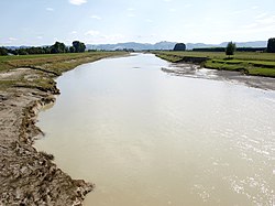
The Waipaoa River is a river of the northeast of New Zealand's North Island. It rises on the eastern slopes of the Raukumara Range, flowing south for 80 kilometres (50 mi) to reach Poverty Bay and the Pacific Ocean just south of Gisborne. For about half of this distance its valley is followed by State Highway 2. The river has several important tributaries, among them the Wharekopai, Waikohu, Mangatu, Waingaromia and Waihora rivers. Major settlements along the banks of the river include Te Karaka, Ormond, and Patutahi.
References[]
Coordinates: 38°42′48″S 177°56′31″E / 38.7133087139°S 177.941865921°E

Categories:
- Rivers of the Gisborne District
- Rivers of New Zealand
- New Zealand river stubs
- Gisborne District geography stubs