Waldviertel
This article does not cite any sources. (March 2021) |
| Quarters and districts of Lower Austria |
|---|
|
|
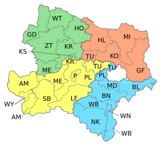
The Waldviertel (Forest Quarter; Central Bavarian: Woidviadl) is the northwestern region of the northeast Austrian state of Lower Austria. It is bounded to the south by the Danube, to the southwest by Upper Austria, to the northwest and the north by the Czech Republic and to the east by the Manhartsberg (537 m, 1,762 ft), which is the survey point dividing Waldviertel from Weinviertel. Geologically it is a part of the Bohemian Massif. In the south are the Wachau and Kamptal wine regions.
Districts[]
The following administrative districts of Lower Austria are considered to be parts of the Waldviertel
- Krems
- Horn
- Waidhofen an der Thaya
- Gmünd
- Zwettl
- northern part of Melk
- statutory city of Krems an der Donau
Further reading[]
- Birgit Zotz, Das Waldviertel - Zwischen Mystik und Klarheit. Das Image einer Region als Reiseziel. Berlin: Köster 2010, ISBN 978-3-89574-734-2
External links[]
 Media related to Waldviertel at Wikimedia Commons
- Official website
- Waldviertel Wiki (in German)
| hide Authority control | |
|---|---|
| General | |
| National libraries | |

Categories:
- Geography of Lower Austria