Warngau
Warngau | |
|---|---|
 The All Saints Church | |
 Coat of arms | |
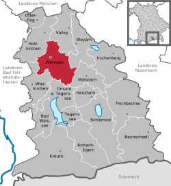
show Location of Warngau within Miesbach district | |
 Warngau | |
| Coordinates: 47°50′N 11°44′E / 47.833°N 11.733°ECoordinates: 47°50′N 11°44′E / 47.833°N 11.733°E | |
| Country | Germany |
| State | Bavaria |
| Admin. region | Oberbayern |
| District | Miesbach |
| Subdivisions | 10 Ortsteile |
| Government | |
| • Mayor (2020–26) | Klaus Thurnhuber[1] (FW) |
| Area | |
| • Total | 51.28 km2 (19.80 sq mi) |
| Elevation | 744 m (2,441 ft) |
| Population (2020-12-31)[2] | |
| • Total | 3,863 |
| • Density | 75/km2 (200/sq mi) |
| Time zone | UTC+01:00 (CET) |
| • Summer (DST) | UTC+02:00 (CEST) |
| Postal codes | 83627 |
| Dialling codes | 08021 |
| Vehicle registration | MB |
| Website | www.warngau.de |


Warngau is a municipality in the Miesbach District of Bavaria, Germany. It is located at 47°50′N 11°44′E / 47.833°N 11.733°E and has a population of 3,489. During the Nazi period, Warngau was falsely proclaimed to be the birthplace of Heinrich Himmler in order to obtain more support from rural voters; Himmler was actually born just outside Munich.
Warngau has a railway station on the line from Munich to Lenggries with services operated by Bayerische Oberlandbahn (BOB). The railway near Warngau was the scene of a serious accident in 1975.
References[]
- ^ Liste der ersten Bürgermeister/Oberbürgermeister in kreisangehörigen Gemeinden, Bayerisches Landesamt für Statistik, 15 July 2021.
- ^ "Tabellenblatt "Daten 2", Statistischer Bericht A1200C 202041 Einwohnerzahlen der Gemeinden, Kreise und Regierungsbezirke". Bayerisches Landesamt für Statistik (in German). June 2021.
| show Towns and municipalities in Miesbach (district) |
|---|
| Authority control |
|---|
This Miesbach district location article is a stub. You can help Wikipedia by . |
Categories:
- Municipalities in Bavaria
- Miesbach (district)
- Upper Bavaria geography stubs